New Editions of Navigational Charts for Auckland Harbour Released
New editions of two navigational charts for Auckland Harbour have recently been released, providing enhanced safety as Auckland mariners take to the water in significant numbers over the summer sailing season. The new charts are the result of a collaboration by Land Information New Zealand (LINZ) and Ports of Auckland in which LINZ updated the charts with data collected by Ports of Auckland.
National Hydrographer Adam Greenland says LINZ, as the New Zealand Hydrographic Authority, is responsible for producing nautical information for safety of navigation including hydrographic surveying and charts.
“We’re pleased that Ports of Auckland has supplied us with high-quality data to update our official charts for the benefit of all New Zealanders,” says Mr Greenland.
Multibeam Sonar
“Mariners using the new editions of the Auckland Harbour East and West charts will see this represented by an increase in the number of depth soundings on the electronic navigational charts and our paper charts,” Greenland says.
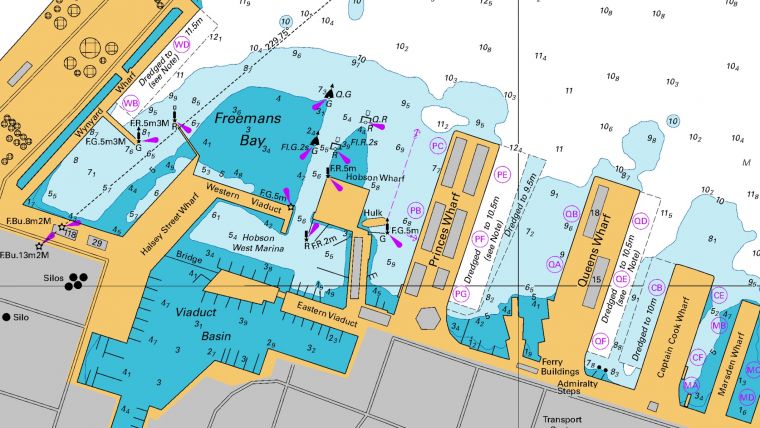
Ports of Auckland’s GM Marine, Engineering and General Wharf Operations, Allan D’Souza, says recent changes to the built environment are now reflected in the charts. Thanks to multibeam sonar equipment on their surveying vessel Acheron, the information displayed on the charts is more accurate and provides more certainty to the mariner. “The most significant changes are the areas of the Viaduct Basin, Commercial Harbour, ferry terminals and Calliope Wharves.”
“I encourage all mariners who use these areas to replace their charts as the harbour enters the peak period for summer sailing,” D’Souza adds.
The Auckland Harbour East chart includes the Viaduct Basin, Commercial Harbour and Calliope Wharves, and the Auckland Harbour West chart includes Kauri Point and Chelsea Wharves. Other improvements include new Aids to Navigation and amendments to existing Aids to Navigation and general updating of official names, coastline changes, magnetic variation, tidal information and minor wharves.
The Auckland Harbour East chart was last updated in September 2018 and the Auckland Harbour West chart in June 2012.
Electronic navigational charts are available at no cost through LINZ’s NZ ENC Service.


