Satellite Assists Northern Sea Route
Satellite-based radar imagery has been used during ice channelling of supertanker SCF Baltica, which is making the first experimental voyage on the Northern Sea Route (NSR). The success of this historical voyage along the NSR is of great importance for the future of commercial cargo traffic between Russia, Europe and China. Time saved when following the NSR route is 45% less than routes using the Suez Canal.
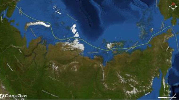
Within August 14-27 SKF Baltica tanker with gas condensate onboard passed from Murmansk to the far eastern point of the Russian continental part cape Dezhnev and followed further through the Bering Strait into the Pacific Ocean. The ship is to get to the destination port of Ninbo (China) on September 6-7. First persons from OAO Sovkomflot (tanker owner) and FSU Atomflot companies - Sergei Frank and Vyacheslav Ruksha respectively - managed the ice channeling operations.
No large-size tankers of ocean class have ever been escorted through the NSR. At different stages of the NSR route, passing in particular through Vilkitsky, Sannikov and Longa Straits, the tanker was escorted by nuclear-powered ice-breakers Taimyr, Rossiya and 50 let Pobedy (50 years of Victory). The convoy came across the patch ice in Kara Sea, crossed the link of the Taimyr ice massif, passed through the open pack ice in the Laptev Sea and packed ice in East-Siberian Sea. Radar images of RADARSAT-1 were used to assess ice situation along the ship route and to select the optimal itinerary.
Receiving centres of the ScanEx's network were used for operational acquisition, processing and transmission of the satellite imagery data: automated ground receiving stations UniScan in Moscow, Megion and Magadan. After processing the product was transferred in real-time via the Internet network through "Atomflot-Kosmosnimki" geo-service. The geo-service was created based on the GeoMixer technology in behalf of Atomflot that placed a request to ScanEx to collect and process satellite radar data in 2010 about the ice situation on the NSR route and the Non-Arctic freezing seas of Russia.
During the summer navigation period FSU Atomflot on numerous occasions used satellite radar data for escorting ships along the NSR route. The work experience shows that the application of space images allows increasing only the safety but the economic efficiency of maritime ice operations under the conditions of Arctica.


