Shipwreck Monitoring in the North Sea
Surveyors Discover World War One Submarine
In order to guarantee nautical depths, the Rijkswaterstaat survey department runs an annual seabed monitoring programme. In July 2019, research vessel MS Arca left its home port of Scheveningen, the Netherlands, to conduct a shipwreck survey that included a World War One submarine.
As an executive agency of the Dutch Ministry of Infrastructure and Water Management, Rijkswaterstaat facilitates smooth and safe maritime traffic in the Dutch North Sea. One of its activities is an annual seabed monitoring programme. Apart from a few deeper spots, the Dutch part of the North Sea is in general 35 metres deep, while the coastal zone is characterized by shallow areas (<20m). The entire area is home to international shipping lanes with heavy nautical traffic. Shipwrecks often protrude from the seabed, posing risks to safe maritime navigation. Hydrographic surveys are therefore conducted to ensure the nautical depth is guaranteed in this relatively shallow sea.
Such surveys have to be repeated periodically, because shipwrecks are far from static. The combination of tidal movement and resulting currents often creates an accumulation of sediment on one side of a wreck, while erosion occurs on the other side. Over time, these banks and gullies cause the wreck to become buried – sometimes to the extent that little is left of what used to be a hazardous obstacle. In that case, the marking buoys around the wreck can be removed. In view of the fact that there are around 850 marked objects in the Dutch North Sea alone, this can save considerable time and resources. In areas with high (≥6m) sediment waves, the opposite can happen; the sediment waves can shift over the years, transforming what was originally just a small protrusion into a fully exposed wreck.
Combined Survey
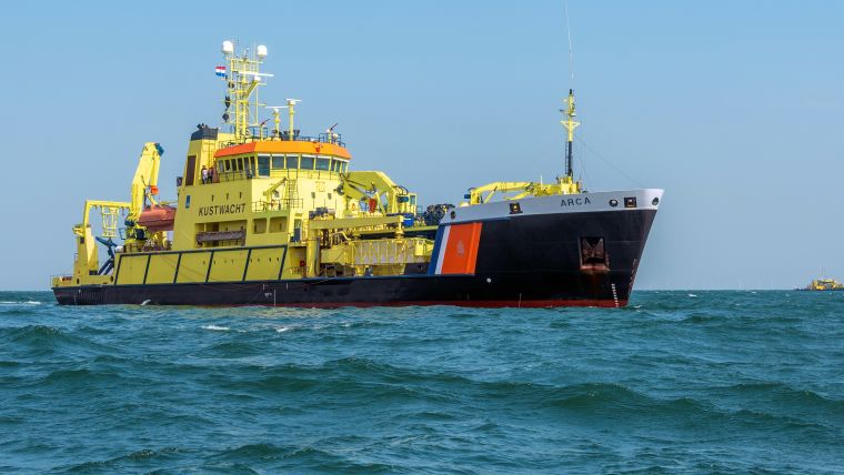
Rijkswaterstaat’s MS Arca has a multi-purpose role. Built as a pollution control vessel, it is equipped with sweeping arms for combatting oil spills. But when not deployed for cleaning environmental spills, it is put to use as a survey vessel. For surveying purposes, it is fitted with a dual-head Kongsberg EM2040c multibeam, a Klein 5000 sidescan sonar and a Saab Seaeye Panther XT. Its motion sensors are the Xblue Phins and Octans IV, and position is provided by two Trimble GPS receivers. All in all, at 84 metres long, it forms a stable platform for offshore operations such as shipwreck monitoring.
Wrecks are monitored by means of a combined survey with multibeam and sidescan sonar. For wrecks that are protruding from the surrounding seabed, several side lines are carefully surveyed. It is not uncommon to survey a wreck in water depths of 12 metres or less, in which case there is always the chance that the sonar itself – if it passes straight over it too deeply – could end up joining the wreck on the sea bottom.
Rijkswaterstaat applies an additional method called water column imaging (WCI) – which is commonly used in commercial fishing activities (i.e. to find fish) – for midwater detection of small or thin objects such as masts, pipes or structures that protrude from the wreck and form the actual shallowest point. Such objects are not normally visible in regular multibeam data or are filtered out as spikes. Since the WCI method is still in the developmental phase, a mechanical check (railing) is conducted. However, promising results have already been obtained in practice.
After the combined survey has been conducted, the data is processed and stored on board. In perfect conditions (i.e. sea state, current and underwater visibility), wreck surveys like these can take up to a day. Once all the data has been secured, the MS Arca can move on to the next wreck on the list.
ROV Inspection
On request, an ROV inspection can be conducted using the work-class remotely operated vehicle (ROV) that can be deployed for a wide range of subsea operations, including inspections. Kongsberg’s hull-mounted HiPAP 502 provides positioning to the ROV, in short base line (SBL) configuration. Underwater visibility in the North Sea is often poor (≤0.5m), especially in early summer when the algae bloom is at its peak. To navigate in poor visibility, the ROV has an acoustic camera. Images and videos are recorded by the camera in black and white. Additionally, an HD camera can be mounted if needed.
ROV shipwreck surveys are not entirely without risk. Due to the low visibility, it is often necessary to hover close to the wreck for clear images, which increases the risk of entanglement of the ROV’s umbilical. Wrecks with a military background may also still contain various types of unexploded ordnance (UXO), in which case it is essential not to physically disturb the wreck.
World War One Submarine
One of the more remarkable shipwrecks surveyed by MS Arca was the remains of a World War One submarine. The submarine is one of the roughly 25,000 objects that are located in the Dutch North Sea. The majority of these objects qualify as low-priority objects (i.e. manmade objects and natural objects such as boulders). Others are listed as shipwrecks, including those with historical value, such as the submarine. Most military wrecks have been given war grave status, meaning items may not be removed from them without explicit permission from the wreck’s home state. Extra efforts are made to monitor the condition of such wrecks.
This particular submarine was hit by a mine just off the Dutch coast while underway to its patrol area in 1917. None of the 34 crew members survived the event. The high-detail multibeam and sidescan sonar measurements indicated that the submarine was still surprisingly intact, with little risk of entanglement, and no UXO was visible. This created the opportunity to move closer to the wreck and perform a complementary ROV inspection. It revealed that the submarine rests in a vertical position, with the impressive bridge rising several metres above the seabed. However, its shallowest point is still well below the area’s guaranteed depth.
Conclusion
Shipwreck surveying can take up several weeks of the annual schedule, but the effort is well rewarded with diverse and interesting results such as the World War One submarine. More importantly, regular surveying guarantees minimum nautical depths to ensure safe passage for maritime traffic in the North Sea.

Value staying current with hydrography?
Stay on the map with our expertly curated newsletters.
We provide educational insights, industry updates, and inspiring stories from the world of hydrography to help you learn, grow, and navigate your field with confidence. Don't miss out - subscribe today and ensure you're always informed, educated, and inspired by the latest in hydrographic technology and research.
Choose your newsletter(s)


