Survey Vessel Delivery and Capacity Building
Italian Hydrographic Institute Supports Lebanon Hydrographic Service Development
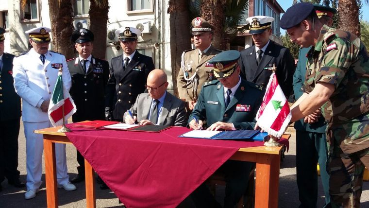
On 20 October 2016 in Beirut, Lebanon, the Italian Ambassador, HE Massimo Marotti, presided over the donation ceremony of a boat for hydrographic surveys donated by the Italian Navy to the Lebanese Navy (Lebanese Armed Forces), represented for the occasion by the Head of Logistics Department, General Kiriejian. The boat delivery is part of a broader project, worth approximately two million euros, which sees the establishment of a Hydrographic Service within the Lebanese Navy.
The event was held in the presence of the Lebanese Navy Commander Gen. Majed Alwan, the Defense attaché of the Italian Embassy in Lebanon, Gen. Pier Luigi Monteduro, a delegation from the Italian Navy Hydrographic Institute in Genoa and Lebanese military and civilian authorities (see Figure 1).
Navi-Gator Survey Vessel
Handing over the hydrographic launch (built in Italy by shipyard Reggiani Aluminium Boats) to the Lebanese Navy was the most significant part of an agreement between the Italian and Lebanese MoDs, aimed at supporting SHMAL and enhancing its hydrographic, oceanographic surveys, geodata management capabilities and, eventually, charting skills.
Italian Navy Lieutenant Enrico Zanone and Warrant Officer Giuseppe Ghirardini (sent to Beirut by the IIM Director Captain Luigi Sinapi) carried out an accurate calibration of the Navy-Gator 27 operational systems and taught SHMAL officers and petty officers how to use them. Technicians from Norbit (manufacturers of the multi-beam echosounder) and from Lighthouse (the company that provided the hydrographic payload) assisted them (Figure 2) .
Finally, the international team carried out a hydrographic survey of the port of Beirut, processed and evaluated the soundings and tidal data (see Figure 3: LT Zanone training a Lebanese operator and Figure 4 Navy Gator testing the multibeam echo sounder in the port of Beirut).
Hydrographic Courses
Before the presentation of this survey vessel, in 2015 one Lebanese officer and one Lebanese petty officer attended the hydrographic courses at IIM. In Figure 5, the IIMI Director presents the coat of arms to the first Lebanese Naval Officer who obtained the Category A certificate. Further training in survey and cartography will be carried out at the IIM and in Beirut. In the near future, Italy will donate SHMAL a total-station, CARIS software and relevant training on their use. If this positive trend continues, the assistance given by the Italian Navy will make SHMAL able to reach the status of a self-sufficient national hydro-oceanographic institution and to provide the Lebanese Government, mariners and scientists with the data required to navigate and to study the marine environment.
Considerations
- The coordinated action of the Italian Navy Hydrographic Institute and of the Lebanese Hydrographic Service is in line with regulation 9 of the SOLAS Chapter V which, in its first paragraph, says: Contracting Governments undertake to arrange for the collection and compilation of hydrographic data and the publication, dissemination and keeping up to date of all nautical information necessary for safe navigation.
- It is also in line with work programme 3 of the IHO (Inter Regional Coordination and Support) on capacity building. Supporting SHMAL is important. In IHO publication C55 (Status of Hydrographic Surveying and Nautical Charting Worldwide) Lebanon is reported as follows: …. The only systematic surveys are in the immediate approaches to the main ports. None are modern…. 85% of the coastal areas (from 0 to 200m depth) was never systematically surveyed.
- The technical characteristics of the survey launch and relevant equipment are more than adequate to meet the IHO Standards for Hydrographic Surveys (IHO publication S-44).
Enhancing the hydrographic capabilities of Lebanon may lead this important Nation of the Eastern Mediterranean to join the IHO as new Member State.
Characteristics of the survey launch Navy-Gator 27
|
Engine |
Nr. 2 Mercury F 115 EXLPT (outboard-gasoline) |
||
|
Max speed |
35 Kts |
||
|
Dimensions |
Length |
8.10 m |
|
|
Width |
2.80 m |
||
|
Height |
3.10 m |
||
|
Electricity supply |
Diesel generator (220 V AC) |
Battery (12 V DC) |
|
|
Max displacement |
3.330 ton |
||
|
Boat trailer |
Length |
9.16 m |
|
|
Width |
2.3 m |
||
|
Height |
1.40 m |
||
|
Weight |
710 Kg |
||
|
Boat cradle |
Length |
3.05 m |
|
|
Width |
2.10 m |
||
|
Height |
0.70 m |
||
|
Weight |
150 Kg |
||
Hydrographic equipment:
|
GPS and Inertial navigation system |
Single-beam echosounder |
Multi-beam echosounder |
Acquisition Software |
Sound Velocity Profiler |
|
Advanced Navigation Spatial Fog Dual |
Valeport Midas Surveyor (33 -210 kHz) |
NORBIT WBMS dual head (200 – 400 kHz) |
QPS QINSy |
Valeport Mini SVP |

Value staying current with hydrography?
Stay on the map with our expertly curated newsletters.
We provide educational insights, industry updates, and inspiring stories from the world of hydrography to help you learn, grow, and navigate your field with confidence. Don't miss out - subscribe today and ensure you're always informed, educated, and inspired by the latest in hydrographic technology and research.
Choose your newsletter(s)


