The New Role of Hydrography in the 21st Century
Evolving from Charts to Geospatial Data
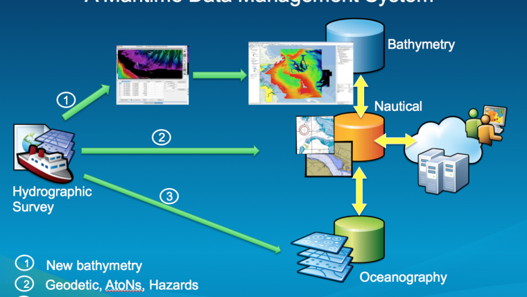
Traditionally, hydrographic data was used mainly for nautical charts. Hydrographic surveys are costly, and data should be used beyond navigation. Some have developed centralised hydrographic databases, but their only purpose is to produce charts. Hydrographic data should be used for other purposes too. Hydrographic data is the foundation for building a maritime data management system, in the framework of a Marine Spatial Data Infrastructure for broader use. Visionary organisations are already evolving their traditional roles and jumping onto the ‘Big Data’ ship and connecting to the World through web services. The use of Hydrographic data is evolving for good.
When someone mentions ‘hydrography’ most people think of nautical charts because its origins are found in safety of navigation. New technologies enable hydrographers to extract more information from collected data than just the sounding and what was ‘noise’ is today valuable data (backscatter). And even other collected parameters, such as sound velocity, temperatures and tides, were only used to correct soundings.
Hydrographers can process more data and bring faster and more accurate results with the new technologies and powerful algorithms; today the sources, magnitudes and variability of acoustic backscatter can be identified and interpreted, and models can be developed to obtain useful information, from seabed sediment classification to water column data.
Extending Hydrographic Data Beyond Charting
Hydrographic data can be collected once and used many times. Technological advances in processing this data give a better understanding of our environment, which in turn opens new opportunities and directly supports the so-called blue economy. This is a key piece of information, which is frequently missed by policy makers because very few people know or understand what hydrography is and because it was defined by one result for centuries: the chart. This chart, essential for mariners, only becomes relevant for the rest of the world when something bad happens. But if hydrographic data is used in a broader context such as in oceanography, pollution control, offshore energy and any other maritime area it becomes essential for geospatial analysis, i.e. for GIS use. All the data collected during hydrographic surveys, such as sound velocity profiles, ADCP casts, sediment classification, tides, currents, turbidity, and shorelines are very valuable beyond ’sounding corrections’ and beyond charts. When used in GIS the ’collecting once and using many times’ becomes real.
Hydrographic data is a critical asset for any activity at sea and in coastal areas, with bathymetry being perhaps the most relevant contribution by hydrography to the marine community; hydrographic data feeds nautical charts and every single maritime project. It becomes a primary data source for a Marine GIS. In the end, hydrographic data contributes to the development of ocean and coastal economic activities, and geographic information systems provide the means to extract the required value.
Hydrographic Data and Spatial Data Infrastructures (SDI)
An SDI provides a framework for organising geographic data, metadata, tools and users with rules, relationships and standards. A Marine SDI is not meant to be separated from other SDIs but is complementary in the coastal zone and oceans. Hydrographic data is the basis of Marine SDIs. Esri supports many SDIs, such as INSPIRE in the EU; a software portal called ArcGIS for INSPIRE supports compliance, data sharing and discovery of harmonised geospatial data across Europe.
All SDIs have similar goals: contributions and data sharing; and have a common denominator: Cloud Computing and Big Data.
Cloud Computing
There are different types of cloud computing service models: ’Software as a Service’ (SaaS), where the end-user applications are delivered as a service rather than installing software on-premises; ‘Platform as a Service’ (PaaS), where an application platform or middleware is delivered as a service on which developers can build and deploy custom applications; and ‘Infrastructure as a Service’ (IaaS), where computing, storage or other IT infrastructure is delivered as a service rather than as a dedicated capability. ArcGIS Online is a good example of all three.
There are public, private or combined (hybrid) clouds with different benefits from each approach.
Big Data
Working with Big Data is challenging because of the volume of the data, the velocity of the data and the variety of the data. The amount of data being collected nowadays is massive. With the grow of social media, multimedia data will continue to grow exponentially in the foreseeable future. In Hydrography, with the use of Multibeam Lidar and Satellite systems for bathymetric data collection in combination with new and more powerful data collection and post-processing software, Big (Hydrographic) Data is a reality, and the challenge comes when the user tries to analyse those huge datasets that can jeopardise productivity. Big Data, when used to its full extent, generates value by way of savings in production and diversifying data use. Users can analyse big data using ArcGIS tools and spatially query billions of records in a matter of minutes instead of hours, simply by taking the software to the data rather than the data to the software, unlocking significant value by making information transparent and usable at a higher rate, connecting and combining hydrographic data with other types of datasets and reaching many more users.
Consumers vs. Enterprise Mapping
We can identify two types of users in the geospatial community. Firstly, people that only access this data for awareness, decision making and planning purposes, called ‘consumers’ of geospatial data. These users are generally positioned at managerial and executive levels in their organisations and are not experts in GIS. Secondly, there is a group of people that collect and analyse data and create products and services, i.e. basically the map and chart makers and GIS professionals. The latter group is always in direct contact with the needs of the ‘consumers’ (their customers) and provides products and tools to attend those needs. Both groups make use of Cloud Computing and Big Data at different levels.
The Challenge: Data Dissemination
But how can hydrography be exploited more efficiently beyond charting? First of all, we need to organise hydrographic data in a logical way, i.e. in a database or several databases, which can be access in different ways by users, for production (like nautical charts) to consumption for analysis, planning and decision making. This is where a national hydrographic office and other hydrographic data producers become key players in an SDI context, building from and contributing to the Marine SDI part (together with other marine entities). Through an SDI, geo-spatial data can be organised, managed and shared among agencies and will finally provide people with useful and authoritative data and products for their day-to-day lives. But making this data available to people can be challenging. With technology such as ArcGIS Server, from which people can deliver hydrographic data as a service, having complete control and centralised management over how and where this data is delivered, deploying it behind an organisation’s firewall or a private instance in a public cloud; or ArcGIS Online from which charts, maps and information can be accessed practically from anywhere, anytime and consumed with free apps from smartphones and tablets. These are cutting edge technologies that can make these processes very efficient. And it does not have to be limited to a one-way dissemination; feedback from users is also a very important part of the cycle. Some people may identify this feedback as the so-called ‘crowdsourcing’, which would warrant a separate discussion.
Land and Sea are Part of the Same Ecosystem
The marine environment is not independent of land. Coastal or littoral areas are transition zones between land and sea, where many people live and where very important economic activities take place. So, why separate land from sea? There is continuity after the zero depth beyond the shoreline, and these adjacent areas cannot be ignored and should be part of the hydrographic data coverage. Tides and currents not only affect navigation, they also have an impact on the littoral areas; a Digital Elevation Model (DEM) is not truncated at the zero depth, in simple terms it is the prolongation of the seabed above water; and the slope and morphology combined with other parameters determine how this ecosystem works and how it can be developed. Hydrographic data is vital for that determination.
Hydrographic Standards
Perhaps one big difference when compared to other marine sciences, is that Hydrography has several standards that form the basis for its collection, analysis and production. The new IHO S-100 Universal Hydrographic Data Model, based on the ISO 19000 series and TC211 for international geo-standards, enables Hydrographers to think GIS; not only to produce charts, but to develop new Geographic Markup Language (GML) schemas to utilise hydrographic data in different ways, from the traditional safety of navigation such as the S-101 next generation of ENCs to the new bathymetry raster standard S-102, or Ice Coverage and any other GML product specification based on S-100. Other industries, such as the Oil & Gas, have developed a geospatial model called the Seabed Survey Data Model, based on the Esri Geodatabase model that may someday become an S-100 based GML. All these are steps towards geospatial data production from hydrographic data, not only charts.
Some Conclusions
Hydrographic data can be considered the foundation of Marine SDIs, and its use goes beyond the safety of navigation, helping Hydrographers and Nautical Cartographers evolve into GIS professionals.
Cloud computing (public, private or hybrid), Big Data and GIS software are part of any SDI and key to using hydrographic data for and beyond chart production.
A modern hydrographic office would evolve into a Geo-spatial Agency, producing data in the four dimensions, and covering the needs from marine spatial planning to the safety of navigation, collecting data once, using it many times and contributing to the development of the blue economy in their countries. That can be considered the new role of Hydrography in the 21st Century.
Rafael Ponce is a Cat. A Hydrographer and gained an MSc. from the University of Southern Mississippi. He was deputy director of Hydrography and Cartography and CO of a Hydrographic ship at the Mexican Hydrographic Office. He retired from the Mexican Navy after 24 years of service and has been Global International Maritime Business Development manager at Esri since 2007.

Value staying current with hydrography?
Stay on the map with our expertly curated newsletters.
We provide educational insights, industry updates, and inspiring stories from the world of hydrography to help you learn, grow, and navigate your field with confidence. Don't miss out - subscribe today and ensure you're always informed, educated, and inspired by the latest in hydrographic technology and research.
Choose your newsletter(s)


