Trends in Hydrography
Taking Lessons from Today's Technical Developments
It’s often a cliché to say that everything offshore has changed since the introduction of GPS, but there have certainly been many changes since back then in the 1980s. The other obvious transformational technology has been computers and computer processing that, like the rest of the world, has totally and radically changed our lives. It didn’t happen immediately of course – no, that would never do in the ultra conservative environment of hydrography and offshore surveying. However, it’s clear when comparing mid-20th century surveying with today that they have totally and fundamentally impacted our projects. Nowadays, such technologies are often taken for granted, but whilst it's totally clear they have been adopted and are omnipresent in our working lives, what lessons can we take when considering today’s technical developments, revolutions and the ever-evolving trends? Gordon Johnston examines the situation.
Time Lag to Adoption
One lesson is that whilst computers and computer processing have developed and continue to do so there is a time-lag between the next development and its full use and adoption. This is in part due to the cost of development and production as well as the availability to the market but also the perceived benefits (or lack of) between existing computing capabilities and technologies.
GPS
A second aspect, when considering GPS, is that the relatively high cost of establishing a radio positioning system (often tens of thousands of dollars) for the very few hydrographic and survey users was massively reduced, when GPS was proven to perform reliably, to a few hundred dollars. The effect of creating something with mass appeal enabled a very high engineering and development cost to be reduced for the user. Again a time-lag occurred as initial coverage, availability and performance issues were dealt with.
Mass Appeal and Availability
A third outcome is that the mass appeal and availability of emerging technologies, especially computers and GPS, have generated a great number of new and innovative uses and applications. An example could be the development of digital cameras replacing film-based cameras and of course smartphones that offer a location and include a camera. It’s perhaps unlikely that many of our hydrographic and offshore surveying developing technologies will see such dramatic change and innovation, but their adoption may be more effective and transformational with integration into and together with other technologies.
So it’s all good and we should be very pleased right? Well, a further lesson to appreciate is that many technologies bring with them some form of unintended consequences. Not all are significant but some are. Few would have thought of the impact modern day DP vessel systems would have on reducing the need for the survey system installations or the security implications of, for example, pirates’ use of AIS (the Automatic Identification System).
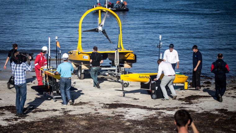
Autonomous and Unmanned Systems
The current technological trends of autonomy and unmanned systems with AUVs and ASVs clearly offer potential advantages for certain projects.As they develop and our appreciation and use increases we may find that there are some consequences we had not fully expected. They can be super efficient resulting in a relatively high unit cost for an area of survey or a period of time. The potential to increase productivity and perhaps reduce certain types of offshore personnel seems likely but they have limited sensor payloads and the technology of autonomous operations, replacement fuel systems and the data drops at each end of mission turnaround may balance these benefits with challenges for certain operations. At least until it becomes clear how best to overcome and reduce these. System integration with a more open architecture and better adaptable capacity regarding data transfer and processing could unlock even greater opportunities as could fuel cell and power storage developments from other markets.
Data Volume Growth
Data, the final frontier for many, which has been with us in some form forever, continues to grow in volume and complexity and consequently offers an opportunity and a challenge. Yes MBES, Lidar, remote sensing platforms and scanning systems create and generate large volumes of data. In fact, the vast volume of data they are generating has caused the traditional silos of the data owners to become too large and cumbersome when filled and data is to be made more and more available for other potential users. In reality, consuming these datasets is constrained due to access being limited, varied formats, limited metadata to explain what is present and simply knowledge of the data’s existence and availability. I anticipate that development efforts will be made to enable these large data volumes to be made more accessible, more easily consumed and to actually provide some additional value and benefits for the wider user community.
Satellite Derived Bathymetry
New technologies for the collection and near-real time processing of large data volumes will continue to evolve and push the data analysts and interpreters into responding with new and more powerful tools. Satellite Derived Bathymetry (SDB) is one developing areas that may have a huge impact on the traditional survey data collection and processing as remote sensing earth observation datasets gain more use due to better resolution, appropriate sensors and their up to date and frequent coverage. More use of SDB is due to the increasing number of users who wish to access data at an appropriate and cost-effective rate.
Backscatter Data
An important recent trend has seen surveys collect not just seafloor depth and associated backscatter data but now more and more operations are able to adjust their data collection to include the water column data. This has a potentially large new consumer base of users interested in the water and oceanographic components.
Data Sharing
Of course, the generation of large datasets is all well and good, but if we are not able to share and distribute the data for the broader community to use then some of the benefits will be lost. Responsible agencies and institutions will endeavour to share their data and the EU has encouraged this through such programmes as the INSPIRE initiative. However, wouldn’t it be great if we had contractual terms that removed the privacy and exclusive use of the data after a reasonable period of time so that we could develop a more recognised supply of information.
So the continual trend of new and ever more data-rich systems will have an impact on some of the traditional projects that we would normally undertake. However, let’s not pretend that SDB or a swarm of AUVs will be totally effective and efficient in mapping our seas and oceans at a useful resolution and accuracy (A totally new topic for later!).
Rather, we still need to develop a seriously efficient, cost-effective mapping technology to cover our seafloors and water column. Currently, AUVs are too slow, of limited power and thus range and duration, but also they collect but don’t easily distribute their large volumes of data.
Resolution
Current global seafloor maps have inaccuracies in their depths of over 1km and much more often of hundreds of metres. Better coverage can be obtained, but SDB is of a relatively poor resolution relying too much on sparse depth measurements to be accurate. AUVs that do offer the ultimate in data resolution are limited by their range and duration. What is really needed is a truly accurate high-resolution surface-based, or near surface-based, system that can operate very efficiently and transfer its collected data as it surveys. You might ask why and to what purpose? Well there are several initiatives to increase our knowledge and understanding of the oceans. A well established one is that of GEBCO (the General Bathymetric Chart of the Oceans) being directed under the auspices of the International Hydrographic Organization and the Intergovernmental Oceanographic Commission of UNSECO. It has recently announced its aim of mapping the worlds oceans by 2030. A significant challenge that would benefit from improvements in acoustic, autonomous vehicle and data processing technologies. Another interesting programme is the Atlantic Ocean Research Initiative that includes, through its Coordination and Support Action, efforts to map areas of the unexplored north Atlantic as part of the Canada/USA/Europe Galway Statement. What these initiatives represent is a clear will, both politically and economically, to further map and understand our seas and oceans. However, for the benefits to be truly realised I believe technological advancements will be required, e.g. in terms of data resolution (it should be in the order of sub 10 metres on the seafloor or at the 0.075 to 0.1 degree beamwidth).
Developing Survey Professionals
A further trend I want to mention is that of demographics. When I started offshore there were surveyors and engineers. Some navy personnel were recorders but that seemed a luxury only available on permanently fitted vessels. Then we got specialist engineers for the acoustics, ROVs, followed later by data processors and report coordinators. The range of equipment appeared to increase too. It was an exciting environment with varied and interesting projects that often involved doing new things. The industry is still exciting, but can we still attract Millennials into our profession and do they have the necessary skill base or is their education leaving our industry behind as they gain alternative new and exciting career opportunities? The development of new technologies can continue to be an attraction to young professionals so it’s important that we support and sustain appropriate training and educational institutions. This could help in determining what skill sets and competencies are of the greatest benefit and those that are perhaps no longer as useful.
Attracting Talent
Whatever technology we develop, adapt and adopt we must strive to inspire, encourage and attract the future talent to ensure that hydrographic surveying remains a truly exciting and rewarding activity. This is a trend that will continue and may become even more vital in our specialist sector to secure a future with skilled people enjoying a continuously evolving career.
Whilst the exciting technology will evolve and hydrography and offshore surveying adapts, we will, as a profession, increasingly make a significant impact on the world. It would be nice if the rest of the world became aware of just how great it is going to be.
More Information
- atlanticresource.org/aora/site-area/about-us/about-us
- atlanticresource.org/aora/sites/default/files/GalleryFiles/Default/GalwayStatement.pdf

Value staying current with hydrography?
Stay on the map with our expertly curated newsletters.
We provide educational insights, industry updates, and inspiring stories from the world of hydrography to help you learn, grow, and navigate your field with confidence. Don't miss out - subscribe today and ensure you're always informed, educated, and inspired by the latest in hydrographic technology and research.
Choose your newsletter(s)


