Vertical Datums in the Hudson River
Interpolation Method to Generate the Separation Surface
A fixed low water reference plane, Hudson River Datum (HRD), was adopted as chart datum for certain portions of the Hudson River to approximate mean low water when river levels are lowest. Due to river discharge, water levels in the river are influenced more by flow than by tides; therefore, tidal datums computed from river water levels might not be representative of low tide levels. Hydrographic surveyors can apply a GEOID model to reference the HRD using Ellipsoidally Referenced Survey (ERS) techniques. Projects not utilizing ERS require a Mean Lower Low Water (MLLW) – HRD separation surface to reduce the bathymetry data to the HRD. This article describes an interpolation method to generate the separation surface using a tool called Tidal Constituent and Residual Interpolation (TCARI).
The Current Definition of HRD
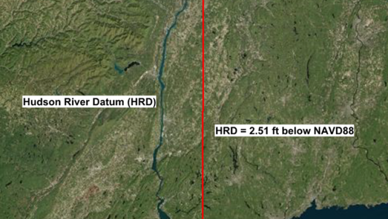
The HRD was adopted by the US Army Corps of Engineers (USACE), New York District in 1926 and was related to the mean sea level at the NOAA tide station at Sandy Hook, NJ (8531680) (Schureman, 1934). The definition of HRD has been modified several times and has since been updated to reference the North American Vertical Datum of 1988 (NAVD88) (USACE, 2015). NAVD88 provides a link between HRD and tidal datums at tide stations (Figure 1).
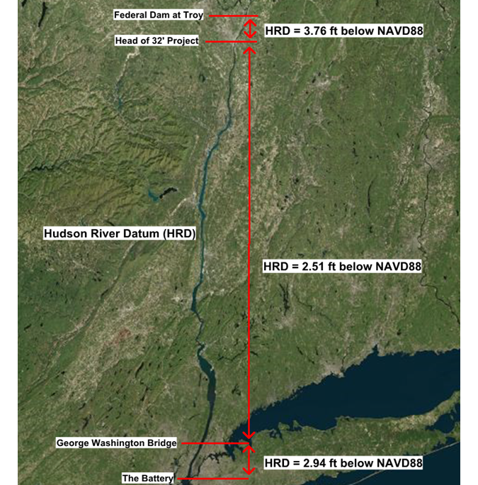
Currently, the USACE relies on the NAVD88-MLLW to relate MLLW to HRD. Where it exists, this separation is obtained using National Oceanic and Atmospheric Administration’s (NOAA) Vertical Datum Transformation tool (VDatum), which transforms geospatial data among a variety of tidal, orthometric and ellipsoidal vertical datums (Myers, 2005). The VDATUM model extends from the entrance to New York Harbour north to East Kingston, NY. For projects north of VDATUM coverage, discrete offsets relate NAVD88 to HRD and are associated with geographic locations along the river (Figure 1). The USACE relies on a HRD separation value of 2.55ft (0.78m) below NAVD88 north to the south of Albany downtown (USACE, 2016). The USACE uses a separation for HRD of 3.80ft (1.16m) below NAVD88 from south of Albany downtown to Federal Lock in Troy and 13.59ft (4.14m) below NAVD88 from Federal Dam in Troy to Waterford (USACE, 2016).
Generating Mean Lower Low Water to HRD Separation Model
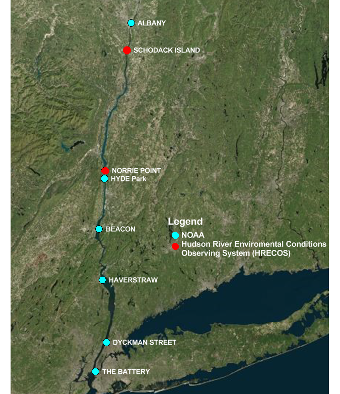
Tidal and geodetic datums from six NOAA water level stations and two Hudson River Environmental Conditions Observing System (HRECOS) stations were used to create a separation surface (Figure 2). Data from the HRECOS water level stations were used to supplement the geospatial coverage of datums from the NOAA water level stations. All NOAA stations have published tidal datums on the 1983 – 2001 NTDE and NAVD88 relationships with the exception of the water level station at Beacon, NY (8518934). Table 1 shows the tidal, geodetic and HRD values that were used to generate the separation surface.
Table 1: Tidal, geodetic and Hudson River Datum values referenced to MSL at stations along the Hudson River. The HRD values are calculated based on the offsets on the USACE dredging chart published in 1986 (Figure 2).
|
Station ID |
Station Name |
Length of Data Series |
NAVD88 (m) |
HRD (m) |
MLLW (m) |
NAVD88 –MLLW (m) |
MLLW – HRD (m) |
|
8518750 |
The Battery, NY |
19 years |
0.063 |
-0.702 |
-0.783 |
0.846 |
-0.081 |
|
8518902 |
Dyckman Street, NY |
3 months |
0.029 |
-0.736 |
-0.702 |
0.731 |
0.034 |
|
8518924 |
Haverstraw Bay, NY |
3 months |
-0.050 |
-0.815 |
-0.550 |
0.500 |
0.265 |
|
8518934 |
Beacon, NY |
3 months |
-0.066 |
-0.831 |
-0.553 |
0.487 |
0.278 |
|
8518951 |
Hyde Park, NY |
3 months |
-0.071 |
-0.836 |
-0.614 |
0.543 |
0.222 |
|
HRECOS |
Norrie Point, NY |
3 months |
-0.042 |
-0.807 |
-0.584 |
0.542 |
0.223 |
|
HRECOS |
Schodack Island, NY |
3 months |
-0.364 |
-1.129 |
-0.846 |
0.482 |
0.283 |
|
8518995 |
Albany, NY |
5 years |
-0.319 |
-1.465 |
-0.869 |
0.550 |
0.596 |
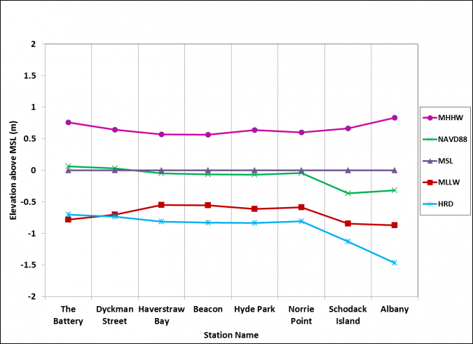
Tidal, geodetic and HRD values are referenced to MSL and shown in Figure 3. All tidal and geodetic datums are above HRD from The Battery, NY (8518750) up to Albany, NY (8518995). Tidal datum values above HRD are consistent with the original purpose of a conservative low water datum. Near the mouth of the river, where the influence of river discharge is minimal, HRD is very close to MLLW. Further north, HRD begins to diverge from MLLW due to increased influences from river discharge.
The separation surface was generated using the Tidal Constituent and Residual Interpolation (TCARI) tool, constrained by the observed datum values at the locations of the eight water level stations mentioned in Table 1. The interpolation scheme uses a 2D Laplace interpolation over a Delaunay triangulation grid constrained by boundary conditions (Hess et al., 2004).
Results
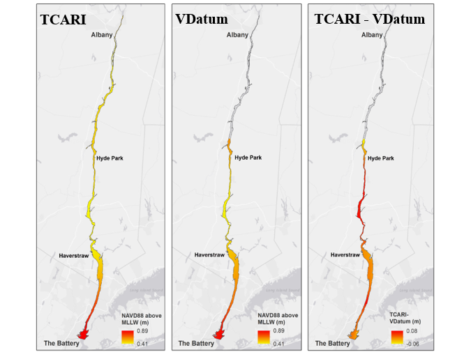
A NAVD88-MLLW datum separation surface was created based on the tidal, geodetic and HRD values shown in Table 1. To quality control the result, the interpolated separation surface is compared to the separation values from VDATUM in the areas covered by VDATUM - Figure 4 shows this comparison. The differences in the separation surface values between the TCARI and VDatum solutions range from -0.06m to 0.08m.
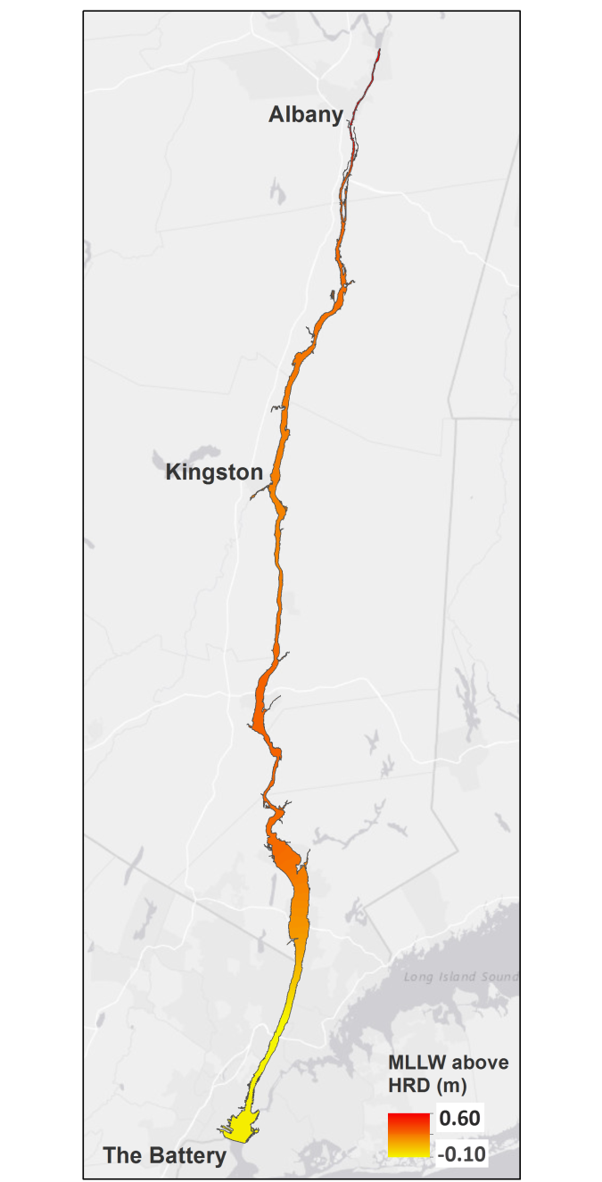
Using the NAVD88-MLLW surface and the NAVD88/HRD relationships shown in Figure 1, the same approach was used to create an MLLW-HRD separation surface. This new surface allows water level data collected at The Battery, NY (8518750) to be biased to HRD throughout the Hudson River (Figure 5).
Discussion and Conclusion
The difference in MLLW-HRD separation between VDatum and TCARI interpolation ranges from -0.06m to 0.08m (Figure 4). The published uncertainty for this VDATUM model is 0.19m (95% CI). With the maximum difference of 0.08m on top of the 0.19m VDatum uncertainty, the separation surface is still within the 0.45m IHO tide error tolerance and can be applied to hydrographic surveys. However, it should be noted that when applied to data, this difference would be realized as a bias, and not a random error.
Improvements to both the TCARI and VDatum generated separation surfaces can be achieved by collecting and incorporating additional tidal datum information along the Hudson River, specifically, between Hyde Park, NY and Albany, NY. The Hudson River VDatum model was created in 2010. Since that time, four short-term stations have been installed between The Battery, NY (8518750) and the northern end of the VDatum coverage: Dyckman Street, NY (8518902), Haverstraw Bay, NY (8518924), Beacon, NY (8518934) and Hyde Park, NY (8518951). Tidal datums from these stations will be incorporated in the updated VDatum model to improve the accuracy of datum transformation.
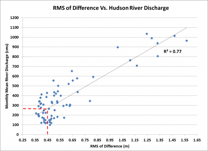
Water levels in the northern Hudson River near Albany, NY (8518995) are significantly affected by high river discharge. A comparison between water level data using The Battery as the control station and observed data at Albany indicates that the 2*Root Mean Square of the difference is less than 0.45m during periods of river discharge less than 280 cubic metres per second (cms). In order to use The Battery, NY (8518750) as tide control for hydrographic surveys in the northern Hudson River, it is strongly recommended that hydrographic surveys only be conducted when the river discharge is less than 280cms (Figure 6).
If an Ellipsoidally Referenced Survey (ERS) is conducted in the Hudson River, then a Geoid model can provide the NAD83 ellipsoid to NAVD88 separation values for the area north of East Kingston, NY where a VDatum model is not available. The offset of 2.55ft (0.78m) below NAVD88 can be applied to the geoid separation in order to relate data to HRD.
References
Hess, K., R. Schmalz, C. Zervas, and W. Collier, 2004, Tidal Constituents and Residual Interpolation (TCARI): A New Method for the Tidal Correction of Bathymetric Data. NOAA Technical Report NOS Cs 4, Silver Spring, MD, 112 pp.
Huang, L., L. Licate, D. Wolcott, K. Kriner, M. Michalski and A. Cariso, 2016. Vertical Datums in the Hudson River. Proceedings of 2016 Canadian Hydro Conference, Halifax, Canada, 16pp.
IHO, 2005, Manual on Hydrography Publication C-13. International Hydrographic Bureau 4, Quai Antoine 1er B.P. 445 - MC 98011 MONACO Cedex Principauté de Monaco, 32pp.
Myers, E.P., 2005, Review of Progress on VDatum, a Vertical Datum Transformation Tool. Marine Technology Society/IEEE Oceans Conference, Washington, D.C.
NOAA, 2001, Tidal Datums and their Applications, NOAA Special Publication, NOS CO-OPS 1, National Ocean Service, NOAA, 111 pp
NOAA, 2003, Computational Techniques for Tidal Datums Handbook, NOAA Special Publication NOS CO-OPS 2, National Ocean Service, NOAA, 90 pp.
Schureman, P., 1934, Tides and Currents in Hudson River. U.S. Coast and Geodetic Survey special publication No. 180, Washington, D.C., 106pp.
USACE, 2015, Hudson River, New York City to Waterford Controlling Depth Report. USACE, New York District, New York, NY, 65pp.
USACE, 2016, Scope of Work Federal Navigation Channel – Kingston to Waterford Reaches Project Condition Hydrographic Survey Hudson River, New York, 6pp.
USGS, 1949, Large Rivers of the United State. Department of Interior, Washington D.C., 10pp.

Value staying current with hydrography?
Stay on the map with our expertly curated newsletters.
We provide educational insights, industry updates, and inspiring stories from the world of hydrography to help you learn, grow, and navigate your field with confidence. Don't miss out - subscribe today and ensure you're always informed, educated, and inspired by the latest in hydrographic technology and research.
Choose your newsletter(s)


