Sentinel-2 satellite-derived bathymetry in optically complex waters
Dublin Bay case study
Coastal areas are highly dynamic environments that are subject to diverse pressures, both anthropogenic (e.g. urban development, fishing, habitat modification) and natural (e.g. storms, erosion, floods). These pressures result in intensive and frequent seafloor alterations that demand efficient monitoring methodologies for repeat updating of the seafloor morphology and bathymetry. Bathymetric information is essential in many coastal aspects, including environmental, management, research and economic.
Optical satellite data provides an efficient alternative to bathymetric derivation in shallow coastal waters (<30m), overcoming financial, temporal and logistical constraints. In 2015, the European Commission, in partnership with the European Space Agency (ESA), launched the first satellite of the Sentinel-2 mission within the Copernicus Programme. This mission currently has two satellites, Sentinel-2A and Sentinel-2B, which register data with a spatial resolution of 10m in some spectral bands. The combination of both satellites provides a revisit time of five days, depending on the latitude. These characteristics offer new potential for coastal applications in general, and satellite-derived bathymetry in particular.
Satellite-derived bathymetry approaches
When using remote sensing data to extract bathymetry, three main techniques can be differentiated: empirical approaches, empirically tuned physics-based approaches, and optimization-tuned physics inversion approaches. Empirical approaches such as machine learning are the newest methods and are not commonly used. The empirically tuned physics-based approaches have the most extended history and are still the most frequently used. In these methods, water column contributions and light attenuation properties are empirically derived from the satellite images by regression with in situ depth data (e.g. nautical charts, echo sounder data or Lidar). However, water turbidity and the seafloor’s influence can limit the performance of these algorithms, which may also be location- or data-limited.
The optimization-tuned physics inversion approaches are more complex, but their use has been consolidated for satellite-derived bathymetry. The application of inversion models does not require in situ depth data, but rather the specification of a range of water optical properties and the seafloor substrates reflectances. These approaches can provide per-pixel uncertainties.
Atmospheric correction
The correction of atmospheric effects is considered a critical step for obtaining accurate satellite-derived bathymetry data. At satellite altitude, up to 90% of the sensor-measured signal can be due to atmospheric and surface reflectance. In this project, several atmospheric correction processors were evaluated to test their influence on satellite-derived bathymetry maps. These processors were OLI ‘lite’ (ACOLITE), the Sentinel-2 data correction (Sen2Cor version 2.4), the image correction for atmospheric effects (iCOR), the Case 2 Regional CoastColour processor (C2RCC), and the Depth Water Correction (DWC). All of these use an image-based approach, which means that all input data is derived from the image itself or provided through pre-calculated lookup tables. Sen2Cor, C2RCC and iCOR are available through the ESA’s Sentinel toolbox in the Sentinel Application Platform (SNAP), and DWC is implemented in the Image Data Analysis (IDA) software developed by Numerical Optics Ltd.
Results showed that the DWC approach produced more accurate and less biased satellite-derived bathymetry maps. This result was not surprising, since the DWC method is specifically designed to correct imagery for applying the bathymetric model.
Empirical tuning models vs model inversion methods
The availability of two Sentinel-2 satellites that can provide a revisit time of three days in Ireland is of enormous importance. This temporal resolution increases the chance of obtaining good images in areas with significant limitations due to weather and water surface conditions. However, even when the Sentinel-2 images were registered in ‘optimal’ conditions, some areas presented certain challenges for satellite-derived bathymetry.
The analysis of the scatterplots (with associated diagnostics) between satellite-derived depth and in situ depth revealed high variability in the results and a clear dependence on the ‘quality’ of the image used. Local and variable turbidity events had an impact on satellite-derived bathymetry, causing an underestimation of depth values. Dark bottom types such as rock and macroalgae also had an effect on satellite-derived bathymetry, potentially causing an overestimation of depth values.
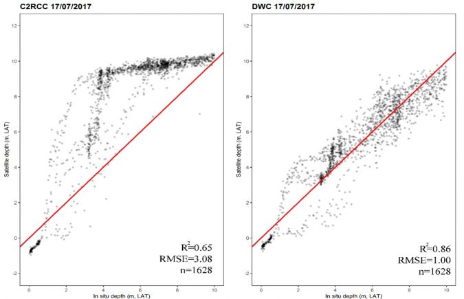
The comparison of empirical tuning models and optimization-tuned physics inversion models showed similar results in Dublin Bay. Model inversion approaches produced an average RMSE and R2 of 1.60 and 0.74 respectively between 0m and 10m depth. The lowest RMSE value was obtained in Dublin Bay on 17/07/2017 (RMSE = 1.00), and was coincident with the image where the highest R2 value (R2 = 0.86) was found. These numbers were quite similar to the ones obtained in previous studies using empirically tuned methods in the same study area. These studies reported values of R2 > 0.80 and average RMSE values of 1.05.
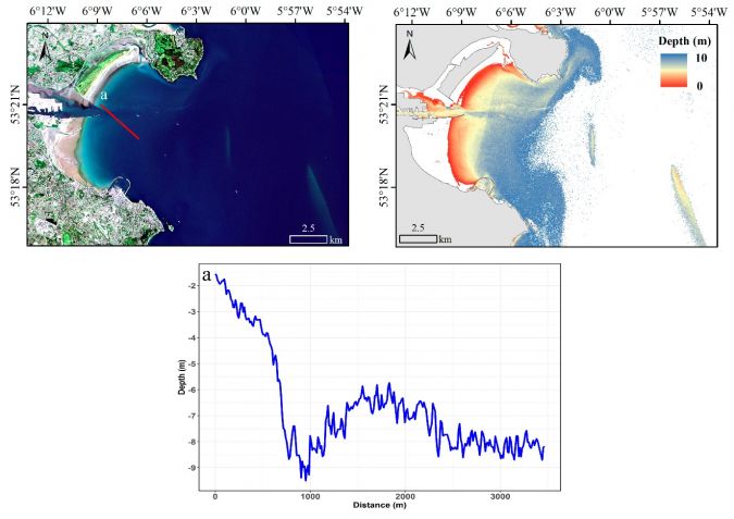
Empirically tuned methods worked well in Dublin Bay because the bay presents a homogenous bottom type and the Sentinel-2 images were selected close to optimal conditions (e.g. low turbidity). However, even if they are more straightforward and easier to use, empirically tuned methods require in situ training data, which is a significant limitation. If such data is lacking, they cannot be used. Empirically tuned methods are also hard to verify since in situ validation data is frequently not really independent of the training data and effectively just repeats the calibration regression fit. The demonstrated accuracy of inversion approaches on the Irish coast could offer a potential solution to cover a different variety of study areas, not only the ones with homogenous bottom types and good water quality conditions. Moreover, inversion approaches can provide information about uncertainty and have the potential to estimate water-inherent optical properties and bottom cover. Nevertheless, under suitable conditions with the best images, depth could be detected in Dublin Bay up to 10m and possibly more, but with decreasing precision.
Conclusions
Sentinel-2 data quality and availability for worldwide coastal regions have increased the attention of coastal managers regarding satellite-derived bathymetry applied research. These results obtained with the optimization-tuned physics inversion approach were comparable to those achieved by empirical tuning methods, despite not relying on any in situ depth data. This conclusion is of particular relevance as optimization-tuned physics inversion approaches might allow future modifications in crucial parts of the processing chain, leading to improved results. Understanding the specific characteristics of each particular site is essential for satellite-derived bathymetry as water turbidity and the influence of the seafloor can limit the performance of satellite-derived bathymetry algorithms.
Acknowledgements
The results and conclusions presented here were obtained within the BaSMaI project. BaSMaI was supported by the Geological Survey Ireland/DCCAE Postdoctoral Fellowship Programme under grant no. 2016-PD-005. The author would like to thank Xavier Monteys (Geological Survey Ireland, Ireland), John D. Hedley (Numerical Optics Ltd., UK), Paul Harris (Rothamsted Research, UK), Conor Cahalane and Tim McCarthy (Maynooth University, Ireland) for their participation and valuable contribution to this project. ESA and Copernicus are thanked for Sentinel-2 imagery. Multibeam data was provided by the INFOMAR Programme. Tide data was obtained through the Irish National Tide Gauge Network.
Further reading
Casal, G., Hedley, J.D., Monteys, X., Harris, P., Cahalane, C., McCarthy, T. (2020). Satellite-derived bathymetry in optically complex waters using a model inversion approach and Sentinel-2 data. Estuarine, Coastal and Shelf Science, 241, 106814.
Casal, G., Harris, P., Monteys, X., Hedley, J., Cahalane, C., McCarthy, T. (2020). Understanding satellite-derived bathymetry using Sentinel 2 imagery and spatial prediction models. GIScience and remote sensing, 57:3, 271-286
Casal, G., Monteys, X., Hedley, J., Harris, P., Cahalane, C., McCarthy, T. (2019). Assessment of empirical algorithms for bathymetry extraction using Sentinel-2 data. International Journal of Remote Sensing, 40 (8): 2855-2879; DOI: 10.1080/01431161.2018.1533660

Value staying current with hydrography?
Stay on the map with our expertly curated newsletters.
We provide educational insights, industry updates, and inspiring stories from the world of hydrography to help you learn, grow, and navigate your field with confidence. Don't miss out - subscribe today and ensure you're always informed, educated, and inspired by the latest in hydrographic technology and research.
Choose your newsletter(s)


