Space-borne Technologies for the O&G Sector
From Operational Environmental Monitoring to Rapid Bathymetry Mapping
This article describes the methods, applications, services and validation of such projects, showcasing the possibilities of these technologies. Satellite-derived mapping and monitoring technologies can provide important support for a range of applications in the oil and gas industry. Satellite-derived mapping and monitoring technologies can provide important support for a range of applications in the oil and gas industry. Prior to tasks such as pipeline routing and other infrastructure engineering activities, these technologies can be efficiently deployed over large, remote and/or in-accessible areas for bathymetry charting, mapping seafloor habitats and monitoring the health of near coastal ecosystems. During dredging activities, satellite-derived products can deliver near real-time, synoptic information on the extent of dredging plumes and the associated sediment loads in the water column. These satellite-based methods can be more rapid and cost-effective than traditional in-situ and airborne measurements and observations and are furthermore entirely non-intrusive.
Prior to tasks such as pipeline routing and other infrastructure engineering activities, these technologies can be efficiently deployed over large, remote and/or in-accessible areas for bathymetry charting, mapping seafloor habitats and monitoring the health of near coastal ecosystems. During dredging activities, satellite-derived products can deliver near real-time, synoptic information on the extent of dredging plumes and the associated sediment loads in the water column. These satellite-based methods can be more rapid and cost-effective than traditional in-situ and airborne measurements and observations and are furthermore entirely non-intrusive. This article describes the methods, applications, services and validation of such projects, showcasing the possibilities of these technologies.
Reducing Mapping Efforts
Aquatic environmental baseline monitoring is often a requirement in the oil and gas (O&G) sector. An important component of this is the continuous mapping of seafloor ecosystems and habitats, a complex activity which can require considerable ongoing effort. Satellite-derived image products can considerably reduce these efforts.
Optical sensors on board remote sensing satellites are able to detect the spectral properties of aquatic targets. Through semi-analytical, radiative transfer inversion algorithms - which include removing the confounding influences of the atmosphere, water column colour and water column depth - these spectral properties can be used to retrieve characteristics of the benthos. From this, the benthic cover can be categorised and mapped, for example as seagrass, coral, sediment, or rubble, or divided into broader assemblage classes or geomorphic zones.
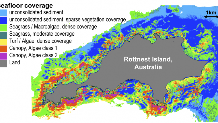
Using 2m horizontal resolution imagery, these technologies have proven capable of deriving contiguous seafloor habitat maps in up to 15m of water depth, water clarity permitting. Validation studies of these seafloor map products for sites in Australia (Ningaloo Reef and Rottnest Island), the Caribbean (Virgin Islands), in Germany and in the Arabian Gulf (Figure 1) show an overall accuracy of 90% or better, when compared with extensive in-situ measurements.
Such accuracies point to the routine applicability of satellite-derived mapping products for aquatic environmental baseline monitoring. An important further advantage to using remote sensing technologies, in this context, is that access to historical archives of satellite imagery enables the retrieval of past environmental conditions, going as far back in time as 20 years or more in the case of data from the Landsat satellite series.
Dredging Plume Monitoring
Dredging in coastal areas or close to vulnerable ecosystems such as coral reefs, seagrass meadows or mangroves is commonly subject to strict environmental regulations. There is consequently a well-defined need in the O&G sector to map and monitor the extent and evolution of dredging plumes, as well as the corresponding suspended matter concentrations in the water column.
Aquatic remote sensing technologies have been applied, combining various satellite sensors, to monitor dredging plumes up to 3 times daily (subject to cloud cover). These water quality maps are in units of absolute concentration values and have a horizontal spatial resolution of between 30-500m, which is often sufficient for open ocean applications. Where necessary, due to plume size and extent, higher spatial resolution commercial data (2–5m) have also been successfully used.
Conventional methods for this type of monitoring often include deploying aircraft with human observers. The satellite-based approach offers numerous advantages over this, including: reduced OH&S risks; removal of potential observer subjectivity (through standardised, inter-comparable map products); rapid delivery of an updated map product (within 2-24 hours of satellite image capture); and considerable cost savings.
Timely delivery is a critical issue for dredge plume monitoring and similar compliance applications, and this can made possible by direct data feed access to the satellite data providers and the fully automated processing systems.
As part of dredging operations in support of shipping channel expansions and pipeline activities for a project off the northwest coast of Australia, Woodside Petroleum commissioned a satellite-based turbidity monitoring system. The need to monitor the dredging plume was critical for this project, as it was located in an area of important marine habitats, including numerous coral reefs. Woodside previously relied on observers in airplanes to perform the monitoring, and found that switching to a satellite-based system enabled cost savings exceeding AUD 1 million for this single project.
Bathymetry Mapping
Bathymetric information is essential for many offshore planning, engineering and even exploration applications in the O&G sector. However, it is often not up to date or even available, particularly at the scales or levels of contiguity typically required.
Echo sounding and Lidar campaigns are time- and cost-intensive and typically require extensive upfront planning. Satellite-derived bathymetry (SDB) maps, in contrast, can be delivered within days of initially identifying the bathymetry information requirement (assuming image data availability). That said, SDB processing and delivery time is nonetheless a function of area size, and can be up to a few weeks for areas larger than one thousand square kilometres (if 2m pixel imagery is being used). The most versatile and accurate methodology for SDB in shallow waters relies on physics-based processing of high-resolution multispectral imagery.
The accuracy of SDB is partly a function of water clarity and depth. From validation exercises covering more than 10,000km2, and ranging from locations as diverse as Australia, Alaska, the Caribbean, the Middle East (Figure 3) and the Baltic Sea, the following accuracies can be considered as generally applicable for SDB: for clear water bodies, maximum depths of 35m can be reached, with an accuracy of within 10% (CE90) for the first 15m of depth; for relatively turbid waters, the maximum depths that can be estimated are approximately 5m, and the accuracy typically decreases, down to within 20% (CE90).
As with seafloor mapping, the advantages of the SDB approach include applicability to remote, extensive, or in-accessible areas, being non-intrusive, providing continuous high-density data in raster map form and being very cost effective. Indeed, based on feedback from numerous bathymetry projects, the costs of an SDB campaign have been calculated to be 5-10 times less than that of comparable traditional methods.
However, it is important to understand the potential uses and limitations of this technology. To begin with, SDB is limited to relatively shallow waters (0 to 35m), but at the same time this shallow zone is also the least practicable and cost-effective zone for ship-based bathymetry initiatives. SDB can therefore play an important complementary role for bathymetry campaigns that include a shallow-water zone. It must be said that SDB is generally not considered as accurate as echo sounding retrieved depths. One alternative approach worth mentioning in this context is the inclusion of a limited number of (significantly more costly) echo sounding, or Lidar transects within an SDB target area. The Lidar data can then be used to fine tune the SDB model. It has been found that this hybrid approach offers a compelling compromise between cost and coverage, where higher than standard SDB accuracies (i.e. consistently better than within 10% accurate in clear waters) may be required.
Conclusions and Outlook
The O&G sector is utilising satellite-based aquatic imaging and analysis technologies for applications as diverse as construction planning, exploration and environmental monitoring. Recent years have seen an increased uptake by the O&G sector of these technologies and the trend looks set to continue. Importantly, satellite-based aquatic products are now reaching a more robust and operational status, as exemplified by projects and applications discussed in this article. Further to this, the specifications and performance of applicable satellite sensors have continuously improved, with new orbiting sensors coming online as soon as 2014, which will underpin the continued uptake of these technologies. The main drivers for this uptake are the considerable savings in labour, time and costs associated with the ability to map extensive or inaccessible areas, rapidly and repeatedly, with standardised units of measure and at relatively high accuracies.
Acknowledgement
The authors would like to thank the chairman of the Oil and Gas Earth Observation Group OGEO Peter Hausknecht for his support. EOMAP’s OEM partner DigitalGlobe is thanked for excellent collaboration in providing satellite imagery.

Value staying current with hydrography?
Stay on the map with our expertly curated newsletters.
We provide educational insights, industry updates, and inspiring stories from the world of hydrography to help you learn, grow, and navigate your field with confidence. Don't miss out - subscribe today and ensure you're always informed, educated, and inspired by the latest in hydrographic technology and research.
Choose your newsletter(s)


