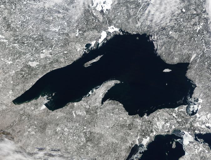
Surveying Lake Superior the uncrewed way
Performing high-quality data collection in a safe and environmentally friendly way
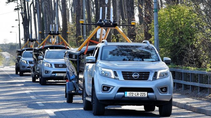
Two uncrewed surface vessels (USVs), remotely controlled via satellite, conducted pioneering survey work on Lake Superior for the Canadian Hydrographic Service (CHS) in partnership with IIC Technologies. The project marks the first time that USV technology has been used to gather bathymetry data in inland waters in Canada.
The Canadian Hydrographic Service (CHS) project was funded through the Government of Canada’s Oceans Protection Plan (OPP) initiative. It was carried out by IIC Technologies and XOCEAN in the world’s largest freshwater National Marine Conservation Area. CHS’s main objective was to evaluate the operational readiness of commercial off-the-shelf USV technology in a real working environment. This included the ability for uncrewed platforms to acquire high-quality data that meets the International Hydrographic Organization (IHO) Standards for Hydrographic Surveys (S-44). The hydrospatial data would later be used to update navigational publications to facilitate safe and efficient navigation and contribute to the blue economy in general.
By testing the technology in this project, the CHS could assess the suitability of USVs as a force multiplier (with a larger survey vessel and/or multiple USVs) to expedite seabed mapping in the Canadian Arctic. The ability to reduce the operational time is important in the Arctic, given the relatively short window of opportunity to survey each year (~July to October).
Challenging environment
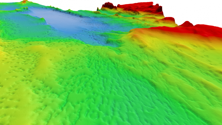
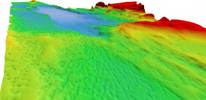
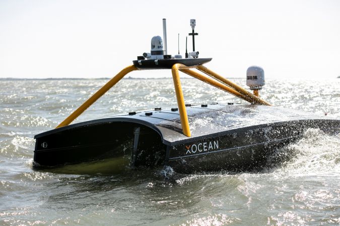
The project area was in the northern part of Lake Superior and the survey was conducted in October and November 2020. The area and timeframe were selected to simulate an Arctic working environment, as the Great Lakes are known for their intense storms and strong winds. An average sea state of 3 on the Beaufort scale, with a maximum sea state of 6, and average wind speed of 25 knots were observed during the survey and transits.
The high winds and low temperatures resulted in freezing spray. It is common for vessels in the region to have ice build-up from these conditions, which can form on just one side and increase the risk of capsizing due to uneven weight distribution. This risk required careful assessment, but the stability of the USVs was not compromised. The low-water USV design and lake water temperature meant that most of the hull was ice free. The convex solar deck, which forms part of the USV’s low carbon hybrid power system, also helped to melt any ice that did form. The freezing spray did result in ice forming on the USV gantry. However, the small surface area prevented large ice formations and did not dramatically change the weight distribution or impact the manoeuvrability of the USVs.
Workflow process
XOCEAN provided and remotely operated the XO-450 USVs from its control centres in the UK and Ireland, while IIC provided the survey party chief, shore-based data processing and logistical support. The USVs are around the size (4.5 metres) and half the weight (750kg) of an average car, and are designed to be remotely monitored and controlled 24/7 via a satellite connection by a team that can be located anywhere in the world. Throughout the mission, the IIC Technologies hydrographers and data processors and XOCEAN USV pilots and surveyors remotely monitored the USVs to ensure safe operation of the vessels and the quality of data acquisition.
The USV automatically followed survey lines during the survey, with the remote pilots monitoring operations. A 50% overlap between adjacent lines was specified by CHS as part of the survey specification and this was entered into the acquisition software (QINSy) AutoSwath settings. The survey lines were not straight but followed the outer edge of the previous swath, maximizing efficiency. The data density, quality and efficiency were all easily controlled. The USV worked for approximately one week before being recovered for data download, refuelling and servicing. After download, the data was backed up and the USV re-launched. While the USV was surveying, IIC processed the data and reported any issues or data gaps to the XOCEAN operators. IIC then performed the final processing and quality control of the data. This workflow proved to be very productive, and by conducting operations 24 hours per day, the crew could take full advantage of weather windows and field personnel could complete the majority of the processing.
Learning opportunities
An important aspect of the project was to record any lessons learned that could be applied to future true Arctic operations. This project presented great learning opportunities for conducting uncrewed hydrographic surveys in northern environments.
The USVs can be conveniently launched using available slipways and boat ramps in the area of operations using a cradle or transport trailer for the USV. It was however noted that, if working in rural and coastal areas, preparations should be made to ensure the launch and recovery equipment can adequately handle poor road conditions (larger/robust trailer tires, etc.).
The freezing spray posed an issue for one of the USVs and resulted in ice blocking the air intake when the gantry froze over. Sections of the USVs closer to the water line proved less prone to freezing, so the air intake was modified by the IIC team on site to place it closer to the water line and prevent future freezing. The air intake, and other considerations for ice, freezing spray and cold should be closely examined for potential weak points, and these factors have already resulted in an improved design of the XOCEAN USV air intake systems for future operations.
Gathering bathymetry data in inland waters
The success of the project demonstrated the highly flexible and collaborative nature of the technology, enabling industry experts to have direct access to real-time data, from any location. The Great Lakes have never been mapped in detail in this area and it is likely that the USVs, which produce negligible amounts of carbon, will continue to be used to collect high-quality, high-density data to support initiatives such as Lakebed 2030, while lowering the environmental impact of marine mapping.
The USV platform has demonstrated itself to be a safe, reliable and carbon-neutral solution for the collection of data for this project in inland waters. The same technology and operational efficiencies can be applied to gather bathymetry data in the Arctic and in Canada’s ocean environment in general. As industry, government departments and academia continue to collaborate to evolve regulations for Maritime Autonomous Surface Ships (MASS) in Canada and other countries, the applications of USV technology will continue to grow for mapping inland waters and the world’s oceans.
A multitude of applications
XOCEAN recently celebrated the milestone of delivering over 100 projects in 14 different countries and passing 30,000 operational hours of USV ocean data collection. There are a wide range of applications for the USV platforms, which can be fitted with a large variety of commercial grade payloads. This includes sensors to collect bathymetry and other ocean data types.
Many stakeholders in the marine environment (government agencies, energy companies, research institutes and others) are interested in improving safety by reducing the need for personnel to be offshore, and in reducing carbon emissions during survey operations. Remotely operated USVs provide this and have been used in projects to inspect assets for offshore wind farms and other renewable energy projects (turbine foundations, export and inter-array cables), oil & gas assets (pipelines and platforms), geophysical surveys for new site developments, data harvesting to download data from subsea systems, fisheries surveys for the evaluation of fish stocks, and metocean data.
How to intervene if something goes wrong
Pilots and online surveyors interact with the USVs through CyberDeck, which is a highly secure cloud-based environment, and XOCEAN’s information security management system is ISO 27001 certified. The control and monitoring of the USV, and online data collection through CyberDeck, is facilitated using several communication channels. These include the primary satellite connection for full uncrewed ‘Over-The-Horizon’ operation, but also 4G cellular and Wi-Fi connections when working closer to shore. As part of safe operations, a back-up mode of communication is needed in the event of a primary communications failure. In addition to the main satellite receiver, the USV is fitted with a back-up transponder for real-time, two-way messaging to ensure communications redundancy.
The trained and certified pilots continuously monitor the USVs using multiple information feeds for situational awareness to make safe and efficient decisions during operations, and to avoid other marine traffic. The information is provided to the pilots through CyberDeck using the satellite (or other) communication link. This includes details of Automatic Identification System (AIS) equipped vessels, four visible light cameras (facing forwards, to port, to starboard and aft), each with a 90° field of view, a thermal camera for use during periods of poor visibility, artificial intelligence (AI) software to analyse the camera feeds and aid in the identification of possible hazards, and Lidar sensors to notify the pilots of any detected objects.
XOCEAN’s operational procedures also employ best industry practices to safely avoid vessel traffic. This includes issuing Notices to Mariners (NtMs) to provide notification to others of the uncrewed operations, and USV pilot standing instructions to maintain safe distances from other vessels and traffic.
Conclusion
XOCEAN has been working with customers in Canada in the second half of 2021 to deliver ocean data for different applications. The projects include an inspection survey for pipeline decommissioning in Nova Scotia, a return to Lake Superior with IIC to collect more high-resolution data for CHS and the mapping of inland waters, and using an XOCEAN USV for the first time in the Arctic for CHS as a force multiplier to perform seabed mapping with IIC and a main survey vessel.
These projects highlight the suitability of uncrewed operations to perform high-quality data collection in a safe and environmentally friendly way in any part of the world, including regions as remote as the Canadian Arctic.

Value staying current with hydrography?
Stay on the map with our expertly curated newsletters.
We provide educational insights, industry updates, and inspiring stories from the world of hydrography to help you learn, grow, and navigate your field with confidence. Don't miss out - subscribe today and ensure you're always informed, educated, and inspired by the latest in hydrographic technology and research.
Choose your newsletter(s)


