Surveying the Wrecks of the Battle of the Atlantic
After years of research, the US National Oceanic and Atmospheric Administration (NOAA) discovered two World War II shipwrecks in 2014 off the coast of North Carolina in the Monitor National Marine Sanctuary. The wrecks form the remains of the KS-520 convoy attack, as part of the Battle of the Atlantic. It was through EIVA NaviSuite software that 2G Robotics modelled these wrecks, once they had been surveyed from a Triton submersible equipped with a Sonardyne acoustically aided inertial navigation system (AAINS) and scanned by 2G Robotics’ laser scanner.
The Battle of the Atlantic was the longest continuous military conflict in World War II, and it lasted throughout the war in an effort to control the sea routes of the Atlantic. The stream of North American war supplies reaching Europe through the Atlantic Ocean was key to sustaining the war effort. The attack on the American KS-520 convoy by the German submarine U-576 on July 15 1942 was part of a naval offensive known as Operation Paukenschlag or ‘Operation Drumbeat’, where individual German U-boats were to hunt down Allied watercraft, instead of attacking in packs. In the initial wave of this operation German U-boats sank over 2,500,000 tonnes worth of Allied watercraft.
Ocean Floor
The convoy, made up of 19 merchant ships, was heading to Florida from Virginia and was escorted by five ships and two aircraft. The German submarine appears to have left its home-bound course, even though it was severely damaged, to try to attack the convoy. Its four fired torpedoes damaged two ships and the cargo vessel Bluefields. The crew of Bluefields managed to abandon the sinking ship. When the U-576 surfaced, it sustained a hit, but sank as the result of depth charges released by the two aircraft escorts. Both the Bluefields and the U-576 sank to the ocean floor, with the submarine taking all of its crew with it.
The U-576 and Bluefields both found their final resting places about 56 kilometres off Cape Hatteras, at a depth of roughly 210-250 metres, lying 250 metres apart from each other.
Wreck Documentation
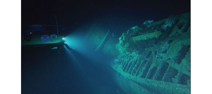
In August and September 2016, the wrecks were documented using a Triton 1000/2 two-person submersible, that was equipped with Sonardyne SPRINT AAINS and 2G Robotics’ underwater laser scanner, the ULS-500 PRO. All sensors produced 3D point cloud data, for the sake of successful cross-comparison of the obtained material. The submersible made a total of 16 passes over the wreck, each lasting 7 minutes at a speeds of 0.5 knots, over the 65- and 85-meter baselines. However, after just 4 passes, with the ULS-500 PRO positioned perpendicular to the seabed on the submersible, a complete 3D model of the U-576 was already composed.
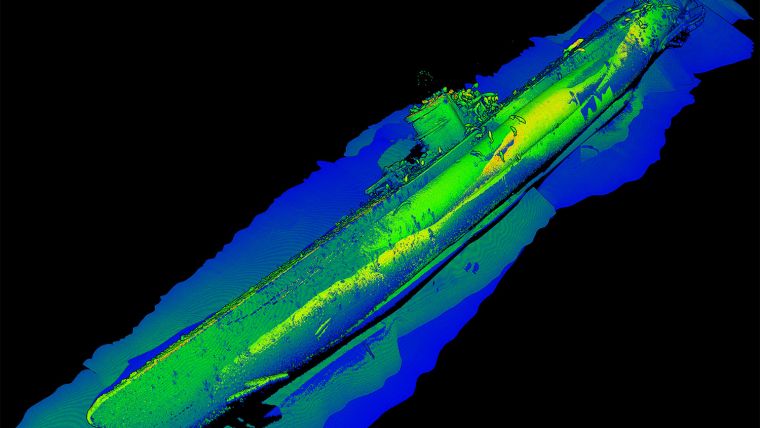
Modelling the Wrecks Down to the Millimetre
The raw laser point cloud data and navigational data from both wrecks were recorded and post-processed through EIVA’s NaviEdit and NaviModel. The raw laser and position data were merged into NaviEdit. The position data was then optimized by georeferencing the point clouds with the help of positioning beacons set up around the wreck sites in a constellation, and after filtering the georeferenced data by intensity, a 3D model display of data was created for visualization and point cloud editing in NaviModel. This method has enabled 2G Robotics to avoid the need to use stitching, thereby achieving greater precision and saving the project valuable time.
“Though we did not use EIVA NaviSuite in a typical fashion it was an easy interface to clean, merge, and visualize all of the data that we had acquired offline,” said Jason Epp, embedded systems developer, 2G Robotics
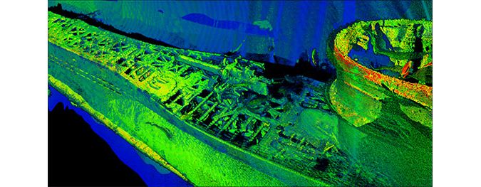
The EIVA NaviSuite products proved crucial in adjusting the positioning of the data, as a result of which the models of the wrecks are accurate down to the millimetre. Hence these 3D models created through NaviModel are able to identify dimensional elements that other methods are not able to detect. Due to the precision of the data, NOAA will be able to observe changes to the site as time progresses, with a hope to gain understanding of any human imprint on the wreck sites, as well as how the sites act as an ecological habitat to marine organisms.
Moreover, by utilizing such 3D models, the condition of the site can be preserved as they can be monitored without any physical contact with the wrecks. It is also possible to use the extensive 3D models for virtual interaction with the wrecks for diverse research, educational and programming purposes.
Find out more on EIVA NaviSuite
Learn more about 2G Robotics Dynamic Laser Scanning

Value staying current with hydrography?
Stay on the map with our expertly curated newsletters.
We provide educational insights, industry updates, and inspiring stories from the world of hydrography to help you learn, grow, and navigate your field with confidence. Don't miss out - subscribe today and ensure you're always informed, educated, and inspired by the latest in hydrographic technology and research.
Choose your newsletter(s)


