“Tharp Helped Keep Me Going”
How a Treasure Map Led Her to the Bottom of the Sea
“It wasn’t always easy being a black woman in my early days as an oceanographer,” says Dawn Wright, chief scientist at a worldwide operating company specialized in mapping and spatial analytics software. But a fictional pirate and a pioneering ocean explorer helped her chart her course.
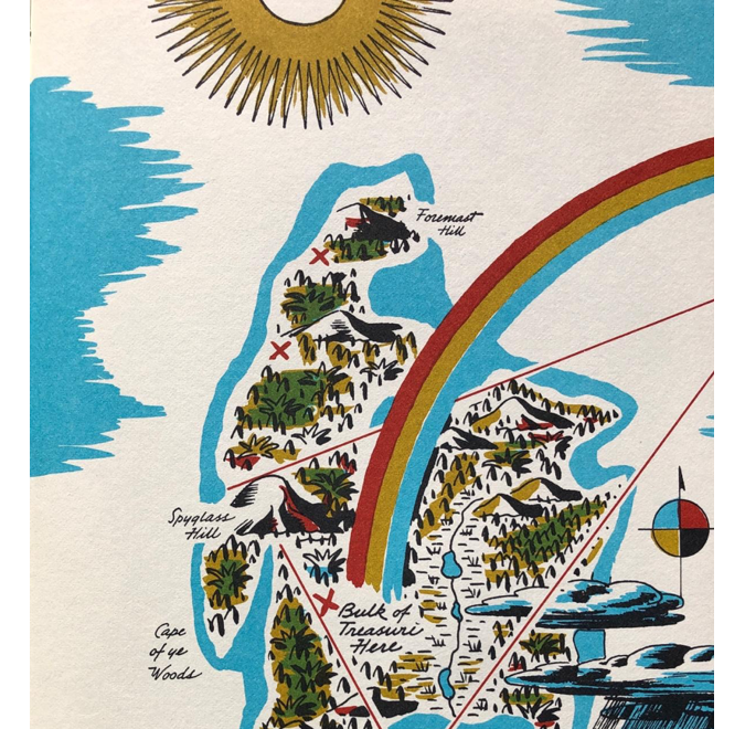
“I grew up in the Hawaiian Islands, so the ocean has always been a sacred place to me. My summers included many hours spent in the waves, and ample time for reading. The book that captured my imagination above all others was Robert Louis Stevenson’s Treasure Island.
“One of the central anchors of the story is Captain Flint’s treasure map. The irony is that, as you read the book, or watch the Disney movie, the details of the map are never revealed. It is just the notion of the map’s existence, and what it could lead to, that drives Long John Silver and others to the point of obsession.”
Mysterious Map
“I fancied myself one of the characters in the story, fascinated by the idea of a pirate’s life, with liberty, equality and fraternity held high. At the beach, I followed imaginary clues and dug for loot in the sands. And I pored over the last page of my leather-bound copy, where a colourful rendition of the mysterious map was included on the inside of the back cover.
“I had no idea at the time as a child what cartography was, but that map fascinated me to no end: the shapes of the landforms, the colours, the arrow pointing north. Not only was I set on a permanent heading towards a love of pirates and pirate lore, I also wanted to know how to better decipher maps, and how to make them myself. I wondered, why did most maps only show the top of the ocean? What is beneath the surface, and how in the world do you make a map of that?
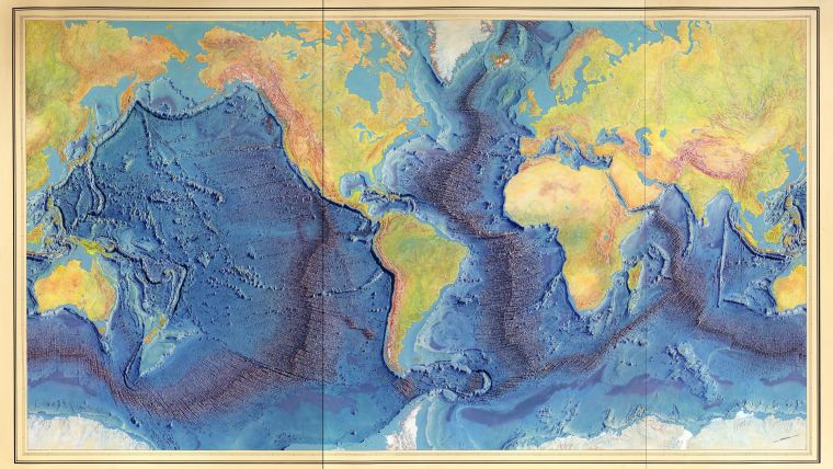
“Those questions ended up launching my career of making real treasure maps of the ocean floor. I studied geology at college, then oceanography at Texas A&M. It was there that I would find another map to my future: the 1977 World Ocean Floor Panorama by Marie Tharp and Bruce Heezen, which adorns the walls of many great institutions of oceanography around the world. It was the first in history to hint at the full scope of what lies beneath the blue.”
Marine Cartography
“I fell more deeply in love with this document once I learned the backstory of one of its creators,” she continues. As a researcher at Columbia University working in the 1950s and 1960s, Marie Tharp began the world’s first systematic, comprehensive attempt to map the entire ocean floor. During the process of translating millions of ocean-sounding records into a single drawing, she discovered a rift valley that informed the theory of plate tectonics. Her contributions were for years left out of historical accounts in favour of her male peers, but now Tharp is hailed as the inventor of ‘marine cartography’. And even though the data upon which her work was based were sparse and far less accurate than what we work from today, the map is still unmatched in its beauty, elegance, and insight.
Like Flint’s treasure map, Tharp’s panorama still invites wondering minds to seek further discoveries in the world it depicts: “It helped inspire me to specialize in the study of the shape of the ocean floor and the geological processes at play. To write my thesis, I travelled along the Tonga Trench in the Western Pacific Ocean, using a sonar ‘sounding’ system to gather yet more detailed swaths of seafloor data.”
Scientific Drilling Vessel
“And it stayed with me as my career took off. Though I hoped to continue mapping unexplored parts of the seafloor after obtaining my Master’s degree, my first post, in 1986, was as a laboratory technician aboard the scientific drilling vessel JOIDES Resolution. This type of vessel does not have sonar mapping equipment; instead, it can lower miles of drill pipe through the entire depth of the ocean to the seafloor, recovering cores that reveal rich paleo-oceanographic history. I sailed on ten of these expeditions, logging nearly six months per year at sea. Though I loved the work, the 12-hour days could be arduous: I was usually one of a handful of women on a ship of 100 people, and always the only black woman. Women were expected to deal with the close quarters and heavy equipment, just as the men were.
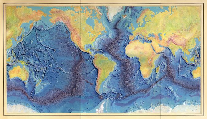
“On the toughest days, Tharp helped keep me going. One of my favourite expeditions was to a famous place boldly depicted in another of her stunning panoramas: the Eastern Indian Ocean. In preparation for the expedition, I had discovered her Indian Ocean panorama, produced in 1967 for National Geographic. Tharp was with me on board, too, in a way: because our ship was outfitted to drill beneath the seafloor, not to map the highs and lows of the seafloor with sonar technology, it was important to have her map on hand to help me understand the features that we were drilling into.
“When we crossed the equator, it triggered a special ceremony – the line-crossing ritual, which was based on US Navy tradition. During these rites, ‘pollywogs’ – those who had never crossed the equator at sea before – have to be deemed worthy of entering the ranks of ‘shellbacks’, or those who had already crossed the equator on prior expeditions, and who are given all sorts of fantastical names. I was over the moon when given the role of one such shellback, Davey Jones, during the festivities on one of those trips. Flint’s map in Treasure Island danced somewhere in the back of my mind.”
Mapping Expeditions
“As my career progressed, I went on to lead my own seafloor mapping expeditions. Now I work for Esri, a private mapping, GIS and geospatial data science company. One of the joys there has been teaming up with kindred spirits who are just as curious about what’s beneath all the blue that most other maps show. Mindful of the high visual standards that Tharp established with her panoramas, we’ve built an entire ocean basemap with carefully chosen colours, saturation and shading, legible labels, and a clear hierarchy of information and coordinates. It’s become a platform upon which other scientists can layer their own discoveries.
“But unlike the maps of Tharp’s time, we can instantly add high-resolution bathymetric data, thanks especially to a global initiative to create a super-detailed map of the entire ocean floor, known as Seabed 2030. Despite all the seminal studies and maps in science, the technology should not cause us to forget the early struggles, triumphs and innovations of the seafloor mapping community – Tharp in particular. And, perhaps, the ocean-braving pirates who first inspired at least one of us.”
This article was originally published on www.citylab.com.
What are the attractive aspects of our profession, why did you choose employment in this industry, what do you see as the most important challenges? These and many other questions often dominate the personal meetings between colleagues. That’s exactly what we would like to highlight. If you want to contribute to this section in Hydro International, please contact Wim van Wegen ([email protected]) or Durk Haarsma ([email protected]).

Value staying current with hydrography?
Stay on the map with our expertly curated newsletters.
We provide educational insights, industry updates, and inspiring stories from the world of hydrography to help you learn, grow, and navigate your field with confidence. Don't miss out - subscribe today and ensure you're always informed, educated, and inspired by the latest in hydrographic technology and research.
Choose your newsletter(s)


