The Growing Range of Uses for Unmanned Systems
Traditional manned survey vessels are often unsuitable, inefficient or incapable of completing a successful survey in challenging locations. In nearshore areas that are difficult to reach for ships and their launches, for example, attempting to conduct hydrographic surveys can pose hazards to both personnel and equipment. Unmanned systems offer a feasible solution in such situations. Unmanned systems can be subdivided into remotely operated underwater vehicles (ROVs), autonomous underwater vehicles (AUVs) and unmanned surface vehicles (USVs). At Hydro International, we have selected a series of articles providing hydrographic surveyors with essential insights into the various application areas for unmanned systems.
USVs Developing into Versatile Tools
Unmanned surface vehicles (USVs) are gaining terrain in hydrographic surveying. They combine the advantages of small survey vessels with those of unmanned survey platforms, giving them a range of applications that is likely to expand even more. They enable hydrographic surveys in a greater number of areas, both inland and offshore. Due to the size of some USVs, they can access waters that are either too shallow for a regular survey vessel or difficult – even dangerous – to access to allow mobilisation of a manned survey vessel. This makes them the survey platform of choice for inshore and coastal areas like confined lakes, rivers, streams and quarry lakes. The surveyor just needs access to a relatively small area of surface water to launch and retrieve the USV. Read on...
Robust Data in Sensitive Environments
There are settings where an unmanned survey represents more than a safe, cost-effective alternative; it may be the only option. Capitol Lake in Olympia, WA, USA, is such a location. In this article, we report on a recent survey that highlights the advantages offered by an unmanned platform operating in a highly public, environmentally sensitive setting. Read on...
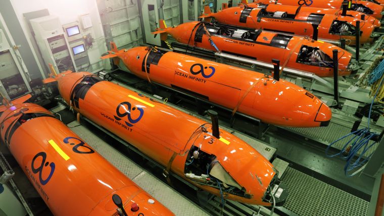
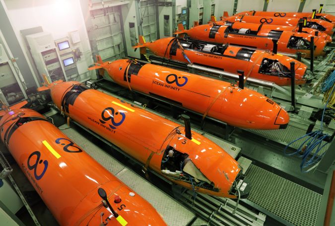
Mapping the Deep Ocean with Multiple AUVs
Ocean Infinity’s seabed mapping campaign commenced in the summer of 2017. The Ocean Infinity team is made up of individuals from multiple disciplines, who have gained vast experience with deep-sea exploration operations in the past. Their combined knowledge and insight led to the idea to undertake deep-sea mapping operations using up to eight autonomous underwater vehicles (AUVs), paired with eight unmanned surface vessels (USVs). This novel concept is explained in more detail in this article. Read on...
Autonomous Vessel Delivers in Challenging Environment
The hydrographic survey industry is changing and moving away from manned operations in an effort to reduce costs and increase safety. During the Shallow Water Survey 2015 conference this new approach and the associated challenges were assessed by Swath Services during the collection of ‘The Common Dataset’ associated with the conference. The aim of participating with an Unmanned Survey Vessel (USV) was to determine if it was actually possible to undertake such a high specification challenge with a USV. The common dataset provides a benchmark against which the performance of the USV can be measured. Read on...
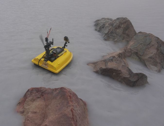
Mapping a Hyper-acid Crater Lake with a USV
The 2,708m-high Poás Volcano is one of the most active volcanoes in Costa Rica, located 35km northwest of the capital San José. This stratovolcano contains a 300m-wide crater lake called the Laguna Caliente (‘hot lagoon’) filled with naturally hot, very acidic concentrated chloride-sulphate brine. Knowing the volume and bathymetry of the lake is crucial in monitoring and predicting the behaviour of this active volcano, but there is no recent bathymetric data available. In this article, the authors explain how they developed a cheap and portable, sonar-equipped unmanned surface vehicle (USV) and used it to survey the lake. Read on...
AUVs in Hydrography
The US Navy and the Naval Oceanographic Office (NAVOCEANO) are committed to realising the vision that Autonomous Underwater Vehicles (AUVs) are available, affordable, and can play a critical role for many applications. Working in partnership with NAVOCEANO and the Office of Naval Research, the Remote Environmental Monitoring UnitS (REMUS) was developed at Woods Hole Oceanographic Institution and has improved positional accuracy due to newly developed technology. NAVOCEANO recently procured a REMUS 600 with a commercial shallow-water multibeam system onboard that meets the stringent accuracy requirements for hydrographic applications. NAVOCEANO hydrographic survey missions can now be augmented by LBS-AUV operations. However, the hydrographer must understand how AUV-relevant parameters affect the data collection scheme. Read on...
Handling Sonar Data from AUV Operations
During the past few years, autonomous underwater vehicles (AUVs) have established a greater presence in the hydrographic survey market and in the collection of oceanographic environmental data. These vehicles can transit nonstop for long periods of time, and can work in areas in which traditional survey vessels are not very effective. Though the cost can be justified over time making AUVs economical for the amount of work done, limitations occur in handling the data from these vehicles. How do we effectively and efficiently go from vehicle to final product? Read on...

Value staying current with hydrography?
Stay on the map with our expertly curated newsletters.
We provide educational insights, industry updates, and inspiring stories from the world of hydrography to help you learn, grow, and navigate your field with confidence. Don't miss out - subscribe today and ensure you're always informed, educated, and inspired by the latest in hydrographic technology and research.
Choose your newsletter(s)


