The Norwegian MAREANO Seafloor Mapping Programme
Although the marine resources in Norwegian offshore waters are quite intensively exploited by primarily the petroleum industry and fisheries, the knowledge about seafloor habitats is scarce. Any destructive consequences from e.g. petroleum-related seafloor installations and fishing gears on the benthic environment may therefore in general be challenging to foresee. Factors that might be negatively influenced may include e.g. benthic species diversity, benthic production and bottom substrate. This, and the need for filling the obvious benthic knowledge gaps offshore, was a main driver behind the establishment of the MAREANO programme – Marine Areal Database for Norwegian Waters.
The process towards a detailed mapping of seafloor habitats in Norwegian offshore waters, headed by the Norwegian Government through the ministries of Environment, Fisheries and Coastal Affairs, Trade and Industry, and Petroleum and Energy, was launched by the establishment of the MAREANO programme in 2005. These four ministries form MAREANO’s steering board. A programme committee, comprising nine State institutions on a directory level, was set up to bring forward MAREANO’s executive activities. A third group – the Executive Team – consisting of one representative from, respectively, the Norwegian Institute of Marine Research, the Geological Survey of Norway and the Norwegian Hydrographic Service, supports the Programme Group. Also a reference group with representatives from scientific institutions, World Wildlife Fund, Fisheries organisations and the bio-prospecting organisation Marbank, was established.
Thus, MAREANO is a multidisciplinary national programme where several Norwegian State institutions participate, clearly showing that the programme is profoundly anchored within the Norwegian State management inclusive of the political authorities. The results form a basic and objective knowledge platform for legislative decision makers, the official management, politicians, NGOs, industry, and fishing organisations.
The MAREANO programme cannot be undertaken without the highly skilled disciplinary participants from the three executive partners. The Norwegian Hydrographic Service carry out multi-beam bathymetry, the Geological Survey of Norway (NGU) produce landscapes and bottom substrate maps, while the Norwegian Institute of Marine Research (IMR) take care of biological field sampling and the subsequent preparation. Chemical studies are done as a joint effort between NGU and IMR. These are all highly specialised institutions, demonstrating the advantages of cross-disciplinary co-operation in projects including multidisciplinary tasks and advanced technical and computing technology.
The tightly integrated co-operation is a critical factor for MAREANO’s ability to produce e.g. detailed biotope and habitat maps. The habitat maps involve data extracted from multi-beam bathymetry and backscatter, geological data, and seafloor species data. These data are statistically analysed and modelled, resulting in full coverage habitat maps in 1:100.000 scales. The official management and decision makers therefore obtain the best possible pre-decisional knowledge support.
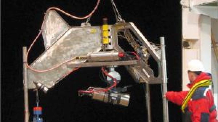
While other scientific marine bottom-dwelling surveys often involve one single sampling gear, the biological part of the MAREANO programme use four different gears, namely grab, sled, beamtrawl and video (the ‘Campod’ rig), each with quite different sampling properties. While video and beamtrawl highlight the animals sticking out of the sediment surface, the grab and sled collect fauna living, respectively, within the sediments and just above the sediment surface. The result is complementary sampling from different vertical benthic layers.
A realistic understanding of the total benthic fauna and biomass is therefore obtained, forming a platform for calculating benthic production that in turn may be coupled to pelagic-living fauna communities. MAREANO’s complementary sampling has shown that the ’invisible’ fauna living beneath the sediment surface, has a higher production (produce more biomass) per square metre than the other benthic faunal levels sampled.
MAREANO has contributed to documenting new species, new habitats/biotopes and new landscapes, and not least the programme has documented the connections between geological and biological processes. For example, deep-sea slices (avalanges) have changed the physical seafloor conditions and topography, and thereby have severely contributed to a faunal change. Additionally, the results from chemical analyses on bottom sediments show that the surveyed MAREANO-areas are not exposed to pollution.
New cold-water coral reef (Lophelia pertusa) areas have been documented, three of which are among the world’s largest cold-water reef complexes. Among these is the 30m high and 10km long Malangsrevet reef, discovered by MAREANO in 2007. The 40km long Röst reef complex, discovered in 2003, has been further mapped by MAREANO and consists of more than 300 single reefs (see Hydro International December 2003 (front cover) and April 2004 (article)). Altogether MAREANO has identified more than 1700 groups of species, and more than 1200 groups identified to species level. Several of these are new to science.
The Røst Reef serves as an excellent case demonstrating the close link between fragile and vulnerable fauna such as corals, and MAREANO’s classification and prediction of benthic habitats. Using the detailed terrain data from multi-beam bathymetry, combining it with backscatter, and using geological parameters such as grain size, the scientists are now able to predict with a reasonable certainty where biologically high diversity areas are found. This is an important input towards the official Norwegian environmental management.
Climate change is an important issue, and MAREANO has contributed to defining representative indicator species that may function as a measuring tool towards future climatic changes. Benthic animals are well-suited for such comparative purposes as they cannot flee from environmental change. The MAREANO results have hitherto found ca. 100 species that may have extended their occurrence towards north, while a handful of species seem to show a more southerly occurrence than known from other earlier investigations.
The background disciplinary report to the revised Barents Sea Plan has concluded that MAREANO-data is highly important to collect information that is needed to revise the management plans in Norwegian waters. Obviously, therefore, huge Norwegian marine areas in the Barents Sea, the Norwegian Sea and the North Sea remain to be surveyed by MAREANO for a couple of decades to come.

Value staying current with hydrography?
Stay on the map with our expertly curated newsletters.
We provide educational insights, industry updates, and inspiring stories from the world of hydrography to help you learn, grow, and navigate your field with confidence. Don't miss out - subscribe today and ensure you're always informed, educated, and inspired by the latest in hydrographic technology and research.
Choose your newsletter(s)


