The Seabed Survey Data Model
An Industry Data Model for Managing Seabed Survey Data
Exploration and Production (E&P) companies spend millions of dollars every year undertaking seabed surveys to acquire data to help in many exploration and production activities such as: determining potential well locations, identifying geophysical hazards (geohazards), the selection of potential pipeline routes and offshore facility locations, and asset maintenance. E&P companies utilise hydrographic survey companies to collect, process and deliver seabed survey data to improve project planning and manage risk. However, to extract the true value from the acquired data there is a need to ensure consistency in how the data is structured and delivered so that it is more efficiently integrated and managed throughout the E&P lifecycle.
In 2006, Shell and Woodside Energy Ltd (WEL) recognised that the true value of the seabed survey data it was acquiring was not being realised. The lack of a defined data model and technical specification for the delivery of survey deliverables were the key reason behind the issues and highlighted the fact that seabed survey data was:
- Difficult, timely and costly to manage internally
- Difficult to integrate with adjoining and/or surrounding survey data
- Problematic when sharing with joint venture partners
- Lacking integration with business workflows.
With this in mind, Shell and WEL embarked on developing a data model that could standardise how survey contractors would deliver future survey data. Like most E&P companies, Shell and WEL utilise GIS technology to manage, map and analyse geo-information via the ESRI technology stack. As a result, the idea was to develop a GIS data model using the ESRI geodatabase. The data model was to model the main geographic entities acquired and interpreted from seabed surveys including seabed features, sediments, shallow geohazards, bathymetry, geotechnical samples and survey project details (extents, zones of equipment use, navigation etc.). The data model was to be commonly referred to as the Seabed Survey Data Model (SSDM).
Improved Workflows
After the development and release of the SSDM, Shell and WEL immediately witnessed improvement in the consistency of seabed survey data deliverables from its survey contractors. While the SSDM required staff from the companies to liaise and work closely with its survey contractors in the initial stages of implementation, the time spent was well worth it. This process also allowed the survey companies to see the real benefit of having a consistent data model for delivering seabed survey data to its clients.
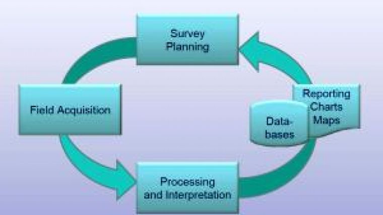
Suddenly, survey deliverables were consistently structured; meaning the QC of the data could focus on the data itself rather than the formatting of the deliverables. It also allowed the SSDM geodatabase to be easily loaded into the corporate spatial database (ESRI ArcSDE geodatabase), leading to a reduction in data being mismanaged and misplaced. This improved survey planning (illustrated in Figure 1, above) also ensured that survey deliverables were stored and accessible to the required groups via corporate GIS layers and web GIS applications sourcing the ArcSDE SSDM schema (example in Figure 2) .
The OGP Initiative
Up until 2009, Shell and WEL had numerous surveys successfully delivered via the SSDM, however, the industry issue still remained. With this in mind, WEL decided to flag the idea of developing a global industry standard for seabed survey deliverables at the 2009 annual International Association of Oil and Gas Producers (OGP) Geomatics Committee meeting. The committee was very supportive of such a concept and in January 2010 the OGP SSDM task force was created. The task force initially contained members from Shell and WEL as well as two other E&P companies and a representative from the Institute of Marine Contractors Association (IMCA).
It was quickly determined that the SSDM developed by Shell and WEL was a very comprehensive data model. This would form a great base from which the SSDM task could develop the global standard that the industry so desperately needed. From January 2010 to April 2011, the task force membership grew exponentially as more E&P companies and IMCA representatives became involved. The fact that survey companies were well represented was important, as the SSDM provides as many advantages for the survey companies as it does for E&P companies. The members representing the survey companies could see that having a standardised data model for all clients would be a more efficient way for them to work. Over sixteen months a vast amount of work was carried out by the task force to develop SSDM V1. This included utilising the Shell and WEL SSDM as a base and using industry feedback from survey companies and software vendors to generate a robust OGP standard. The work undertaken can be summarised in the table below:
On 19 April 2011, the OGP released SSDM V1 at the ESRI Petroleum User Group Conference in Houston. The material that made up the standard included an ESRI geodatabase template, data dictionary, user and contractor guidelines, conceptual data model diagrams, mapping symbology standards, ArcSDE/corporate spatial database implementation guide as well as an over-arching technical guidance note.
Areas of Application
At present, the main areas of the SSDM application are:
1. Platform and drilling hazard site surveys - shallow geophysical and high-resolution 2D/3D seismic (see Figure 3).
2. Sweep and bathymetric surveys - Side-scan sonar and single-beam/multi-beam echo sounder.
3. Pipeline route surveys, pipeline span/surveillance/inspection surveys using side-scan sonar, but excluding ROV based pipeline inspection survey.
Infrastructure and pipeline features were deliberately omitted from the SSDM. While seabed surveys are often conducted in and around subsea installations and infrastructure, there are already a number of existing data models in place covering these data types e.g. APDM, PODS, PPDM etc. As a result, the OGP SSDM task force wanted to avoid re-inventing the wheel by developing another data model for infrastructure and pipelines. Therefore, the OGP SSDM standard encourages E&P companies adopting the SSDM to ‘bolt-on' their preferred corporate data model components for pipelines and infrastructure into the SSDM geodatabase. Typically, these will be pipelines, pipeline events (e.g. free spans), and pipeline stabilisation features, etc. At present, there are a number of companies adopting the SSDM that have integrated their corporate infrastructure model into the SSDM so that it can be used to feed the corporate infrastructure database with inspection data collected in the field.
Technical Details
The OGP SSDM V1 geodatabase provided contains thirty feature classes set up into four feature datasets (survey measurements, seabed features, shallow intermediate geology and environmental samples) and one geodatabase table called T_Survey_JobDetails for storing survey project related information e.g. survey assurance plans, contract numbers, etc. All feature datasets in the geodatabase are set up using the WGS84 geographic coordinate reference system (CRS), however, these can be easily modified into the required CRS for a particular survey project utilising ESRI ArcCatalog. The structure of the SSDM geodatabase can be seen in Figure 4 below.
The Future of the SSDM
The ongoing maintenance of the SSDM will be undertaken by the SSDM task force. It is envisaged that new versions of the data model will be released when there has been enough industry feedback to warrant changes being made to the model. At this relatively early stage, it is believed that this may translate to a new version of the model being released every twelve months or so.
The SSDM task force has a range of activities planned for 2011/2012 to further enhance the SSDM standard which includes the OGP SeabedGML feasibility study, the development of CAD SSDM templates for AutoCAD and Microstation as well as further developing the SSDM symbology and training material. These projects will be worked on while the OGP SSDM V1 has an opportunity to be widely utilised and digested by the industry over the next year.
| Date
| Milestone
|
| January 2010
| Shell and Woodside supplied technical specifications to other parties
|
| May 2010
| Paper produced and posted to the OGP website to summarise the task force progress and feedback on the Shell/Woodside SSDM
|
| July 2010
| OGP Technical Workshop held in Shell Miri office where the OGP SSDM V1 beta material was developed
|
|
|
|
| August 2010
| Material from the technical workshop forwarded to task force members for beta testing
|
| September 2010
| Beta testing feedback being implemented to make OGP SSDM V1 more robust
|
| October 2010
| Seek endorsement from the OGP Geomatics committee to release SSDM V1 to industry. Committee agreed a further round of industry feedback required before the model was to be launched at the ESRI Petroleum User Group Conference in April, 2011.
|
| December 2010
| The SSDM task force posted on the OGP site an invitation for additional industry feedback (including software vendors e.g. ESRI, IVS 3D, CARIS)
|
| January 2011
| Feedback collated and final SSDM changes to the OGP SSDM V1
|
| April 2011
| The OGP Geomatics Committee officially agreed to release the data model as an OGP standard
|

Value staying current with hydrography?
Stay on the map with our expertly curated newsletters.
We provide educational insights, industry updates, and inspiring stories from the world of hydrography to help you learn, grow, and navigate your field with confidence. Don't miss out - subscribe today and ensure you're always informed, educated, and inspired by the latest in hydrographic technology and research.
Choose your newsletter(s)


