Tsunami Local Alarm System
Tsunamis are in no way a new phenomenon, but the December 2004 tsunami drew attention to warning systems and generated new ideas for those capable of providing timely warning, even when a tsunami is generated near the coast. This article describes such a system, currently at a conceptual stage.
The disastrous submarine earthquake of 26th December 2004 to the west of Sumatra caused a tsunami that cost the life of hundreds of thousands. It devastated communities and infrastructure and deprived people of the means of sustaining themselves. Disastrous tsunamis have been known throughout history, such as the one that destroyed Lisbon in 1755 or the immensely fatal one at Messina in 1908, and there have been many more. Tsunamis are among the gravest threats to people and communities along large parts of the world's coasts. Of two things we may be sure: there will be more and we will not be able to predict them.
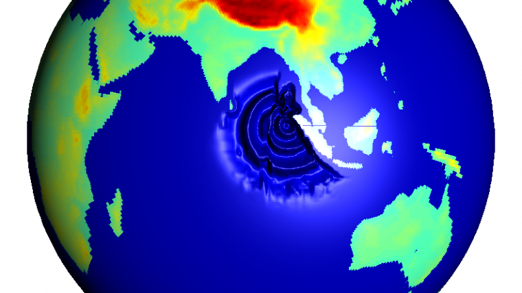
The cause of a tsunami is often an earthquake in the ocean floor. From space a tsunami may be seen as a ring-wave propagating from the epicentre of the quake, looking like the waves created by a stone thrown into water. Upon reaching very shallow coastal waters the tsunami rises. A big tsunami will run up on the shore with immense destructive power, no longer as a wave but rather a wave front or wall of water, followed by yet more, for a minute or more. It exerts huge force on any object still standing, force equivalent to or exceeding that exerted by the air during a severe tropical cyclone.
Earthquakes cannot at present be predicted, and so neither can tsunamis. But much effort is being put into detecting them once they have occurred. The purpose is to warn before the tsunami reaches a coast. Warning systems must be capable of warning in time even if the tsunami is generated near the coast. Here de-scribed is a tsunami warning system of a new kind, one that gives timely warning. The system is relatively simple, cheap and easily deployable, and it works even if telecommunications are destroyed. No au-thorities or other middlemen need to act. We call it Tsunami Local Alarm System or TLAS.
The principle is to place a tsunami detector on the sea bottom off the stretch of coast to be monitored. If a tsunami passes, a buoyant courier is released. This rises quickly to the surface and sends a radio signal that directly activates sirens or other warning signals ashore. By deploying the system a suitable distance offshore, alert times of five minutes or more can be as-sured: a short but crucial alert time.
Birth of a Tsunami
In an earthquake the Earth's crust breaks and pieces move. The rupture can propagate along a path for hundreds of kilometres. It is as if the ocean floor is unzipping at a thousand kilometres an hour. The ocean floor can move in two ways. If the movement is purely horizontal the water is not affected. But if the bottom moves a couple of metres vertically in a few seconds, the whole water column above is forced to follow. A kilometre or more of water column is quickly lifted. The area of the earthquake and of the lifted water can be many hundreds or thousands of square kilometres. Kinetic energy is transferred to the water and the result is formation of a tsunami.
Tracing the Source
The earthquake generates movements that propagate into the interior of the Earth as well as along the surface of the crust. Seismic waves move much faster than the tsunami. By observing the seismic waves one can thus detect, locate and measure the strength of an earthquake before the tsunami has travelled very far! All over the globe seismometers are continuously registering seismic waves and the information is being quickly disseminated to many institutions. Some tens of minutes after an earthquake, its location and magnitude is established.
Unfortunately, calculation of detailed movement of the Earth’s crust requires more time. And, as we know, it is necessary to know the movement of the ocean bottom to decide whether a tsunami has been generated or not. The earthquake on the 26th December 2004 took place close Sumatra and Thailand. The delay between the quake and the arrival of the tsunami was less than the time needed to detect the quake, not to mention to determine its characteristics.
A tsunami warning system depending on seismic determination currently suffers from three weak-
nesses: it introduces delay and cannot quickly determine weather a tsunami has been generated or not. Thus the system must reasonably issue a warning every time it detects a major submarine quake, and will therefore issue a lot of false alarms. The credibility of such a system may therefore deteriorate and it will seriously fail its purpose. Further, a seismic tsunami warning system needs a system for distributing warnings to people along the coast where the tsunami will hit, and not to others. The selection of whom to warn and the distribution of these warnings down hierarchical levels of telecommunication also requires time: time taken from the advance warning time. Finally, tsunamis generated not by earthquake but for instance by submarine landslide will go unnoticed.
Tracing the Tsunami
One way to quickly determine whether a tsunami has been gener-ated or not is to measure the ocean. A tsunami in the deep ocean is a long wave with a wavelength of tens to hundreds of kilometres and wave height of a few decimetres to a metre. Only when the tsunami enters very shallow water does the height increase appreciably. If you are out in deep sea on a ship that is overtaken by a tsunami you will be lifted a metre over some ten minutes and then lowered by the same amount over the next ten. The movement, of course, is not noticeable if you do not have a height reference; which you do not if there are a few kilometres to the bottom, wind waves and swell of a couple of metres.
To detect a passing tsunami you place a scale that continuously weighs the water column on the bottom. The scale must be very sensitive. If depth is one kilometre and the tsunami is one decimetre high, the scale must have an accuracy of 1/10,000. The scale is actually a pressure gauge connected to a buoy on the surface, the buoy communicating with land via satellite. When a tsunami passes, a chain of messages is activated that ultimately communicates warnings to people on threatened coasts. This method is used today, for instance, in the Pacific Ocean.
The advantage, as compared to seismic systems, is that one detects only tsunamis generated, and no false alarms. The drawback is that the chain comprising pressure gauge, buoy, satellite etc. is a complicated and exposed system. The buoy, for example, is a highly sophisticated piece of equipment floating far out in a harsh ocean environment of storms and salt water. Another drawback is that a tsunami detector located far offshore will detect a tsunami generated close to the shore only after it has already reached it: too late. To avoid this, many tsunami buoys may be employed along threatened coasts. Since these buoys are complicated they are also expensive, and so we have not seen this alternative realised.
TLAS
The Tsunami Local Alarm System avoids these drawbacks. It is deployed on the bottom at a depth of several hundred metres. Because it needs no surface unit or bottom-to-surface link, costs are reduced and reliability increased as compared to the other systems mentioned above. It has a pressure gauge and detector unit sensitive only to tsunami waves and not to tides, swell etc. If a tsunami is detected, a strongly buoyant and streamlined courier is released from the bottom unit. The courier quickly surfaces and sends a signal to shore that automatically activates sirens and other means of warn-ing. The equipment needed for this is simple and there is no need for working telecommunications or power systems.
Thus TLAS is independent of systems that often work poorly in threatened areas. These features add robustness and integrity as compared to alternative methods that, as described, rely on working hierarchical levels of global and local telecommunications and the actions of working authorities. The advance warning time depends on how far offshore the TLAS unit is deployed, but at least five minutes should be achievable with realistic offshore topographies. Since TLAS constitutes a cheap and robust system it is possible to deploy it on many sites along a coast threatened by tsunamis.
A civil society that cares for its citizens is a prerequisite for any tsunami warning system to have any purpose whatsoever. The public needs information and training, in advance and on a regular basis, in what to do when the warning comes. We think that this must actually be an integrated part of any tsunami warning system!
The TLAS exists today at conceptual level only.

Value staying current with hydrography?
Stay on the map with our expertly curated newsletters.
We provide educational insights, industry updates, and inspiring stories from the world of hydrography to help you learn, grow, and navigate your field with confidence. Don't miss out - subscribe today and ensure you're always informed, educated, and inspired by the latest in hydrographic technology and research.
Choose your newsletter(s)


