Uncrewed surface vehicles monitoring lava flow
Going where no humans should go
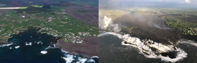
The Kilauea volcano eruption on Hawaii’s Big Island has captivated the world. The images broadcast each day convey the power of the molten lava flowing from the Kilauea volcano to the sea. Its continuous flow is devastating neighbourhoods and communities, has filled pristine Kapoho Bay, and is ultimately changing the shape of the Big Island of Hawaii forever.
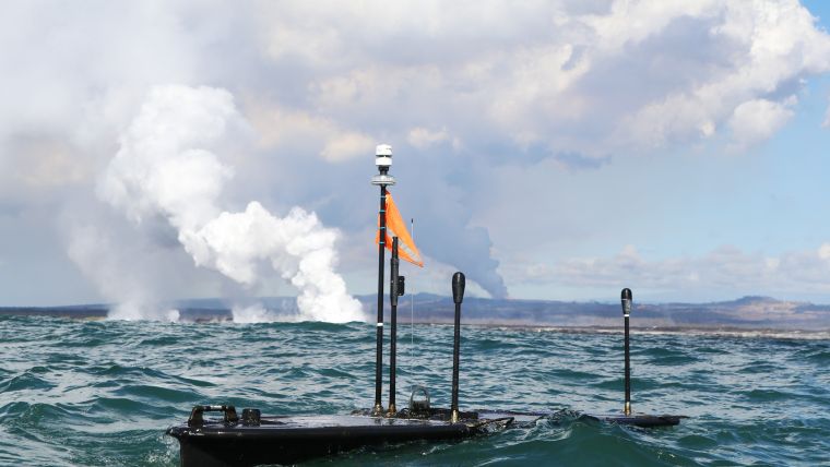
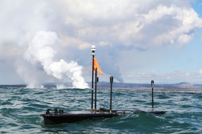
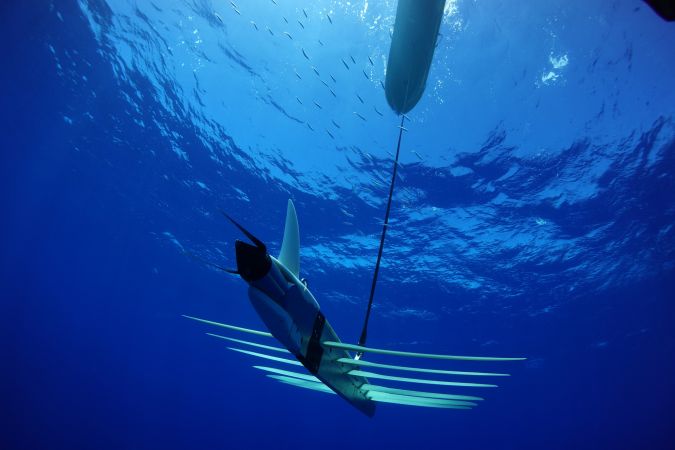
Kilauea’s eruption provides a rare scientific opportunity to study the impact of the lava flow on the ocean and its marine life. However, collecting ocean data during a live volcanic event is extremely difficult and as a result rare. In recent history this has only been done a handful of times and for limited time periods. Why? The danger. On the US Geological Survey’s Hawaiian Volcano Observatory website, they warn of the hazards of being around the lava entry points. Flying debris and sudden explosions from the interaction between the lava and water can occur. This interaction produces ‘laze’, a corrosive seawater plume laden with hydrochloric acid and fine volcanic particles, that can irritate the skin, eyes and lungs. Did we mention scalding water temperatures? Certainly not an environment for humans to operate in. But suitable for an ocean robot such as Liquid Robotics’ Wave Glider, the world’s most experienced uncrewed surface vehicle.
Liquid Robotics’ hometown mission to monitor lava flows
Given this disaster was occurring on a place Liquid Robotics calls home, the Big Island of Hawaii, it didn’t want to just stand by. Liquid Robotics wanted to help. They decided to mobilize their wave gliders to help scientists better understand the dynamics of this rare volcanic event.
Working with Dr Steve Colbert from the University of Hawaii at Hilo, Tina Neal, scientist in charge from US Geological Survey’s Hawaiian Volcano Observatory (USGS-HVO) and Dr Jesse Kroll, Massachusetts Institute of Technology (MIT), configured two wave gliders with sophisticated sensors and cameras (see side insert) and sent them on their mission to measure and monitor the water conditions, air quality, underwater acoustics and plume flows. As noted, it is a rare opportunity to gain real-time data on the impact of a live lava flow on water temperatures, coral reefs, fish populations and other marine life. Measuring laze from the ocean will provide insights into the air quality and patterns caused by the hazardous toxic fumes.
The mission, approved by the US Coast Guard, will continuously collect oceanographic, atmospheric and acoustic data outside the restricted lava area for three to four weeks (ending in late August 2018). Using uncrewed vehicles makes it possible to safely go where no human wants to – near the live lava flow, approximately 100 metres from the entry point. The wave gliders will repeat a precise, zig-zag course collecting data continuously, day and night.
Early insights – scalding water temperatures
As Liquid Robotics were preparing for the mission, they were told that the estimated water temperature 100 metres from the lava entry point would be around 35°C/95°F. When the first wave glider arrived on site, approximately 500 metres from the entry point, the on-board fluorometer recorded an actual temperature of 49°C (120°F). This is dramatically different and shows the importance of live, in situ data. Water temperature measurements taken below the surface around the wave glider’s sub were approximately normal.
Many questions arise from these extreme water temperature recordings. How does the heat affect the local currents, winds and wave heights? Are these conditions extreme enough to affect ocean properties to a small degree for a substantial distance? What is the increased temperature effect on the coral reefs and fish populations? Answers to these and many others will become clearer as the researchers analyse the data.
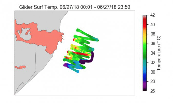
Measuring thermal fronts with wave gliders
Advanced research into the dynamics of ocean fronts and their impact on ocean ecosystems is being done by Monterey Bay Aquarium Research Institute (MBARI). Their ongoing research uses wave gliders to autonomously detect and track upwelling fronts based on the horizontal gradient of near-surface temperature measured by the vehicle. A perfect approach to track and measure the ocean fronts and plumes generated from the Kilauea lava flows.
Working with Liquid Robotics, MBARI researchers quickly applied this method to studying the thermal front between the lava-heated water and the colder surrounding water. They programmed the wave glider tracking on a zig-zag path. Their algorithm calculates the horizontal gradient of temperature in real time. When the gradient exceeds a threshold, the vehicle reports front detection, continues flight for a short time (to cover the frontal zone), and then turns onto the next zig-zag leg. The wave glider zig zags through the front at high spatial resolution to map the front and track its temporal evolution.
MBARI’s work using wave gliders for the ‘auto-pilot’ tracking of ocean fronts during the Kilauea volcano lava event will help scientists better understand the impacts of thermal lava plumes on the ocean’s phytoplankton – the foundation of the ocean’s ecosystem.
Autonomous systems – keeping humans out of harm’s way
The Kilauea volcano lava mission is a prime example of the benefit of using ocean robots to collect important data when the risk to humans is too high. Using wave gliders, researchers can comfortably stay on shore analysing data versus venturing out on research boats that pose high risks. With autonomous systems, the need to actually manually collect the data required for research will soon be an approach of the past. This will reduce the costs and risks to scientific and commercial research.
A treasure trove of data
These are early days for this amazing mission. Scientists will be analysing the data for some time. However, Liquid Robotics are confident that this data will provide rare insights into how the Kilauea volcano lava flow is impacting the Hawaiian Island coastline, ocean and marine life. A treasure trove of data that will provide insights on how we can better protect and care for the Hawaii Island ocean ecosystems, its people and their generations to come.
The two wave gliders were heavily configured with a wide array of sensors to measure the conditions on the surface, underwater and in the air.
Wave glider #1, named Wa’a
- Seabird CTD – sub-mounted, measures conductivity, currents and pressure (depth) from the lower sub
- Seabird CTD – float mounted, measures conductivity, currents and pressure (depth) from the surface
- Turner Instruments C3 Fluorometer – float mounted, measures fluorescence in the water
- GPS Waves – float mounted, GPS sensor for monitoring ocean wave dynamics
- Airmar 200 WX Weather Station, measures wind speed, barometric pressure, air and wind temperatures and relative humidity
- Sulfur Dioxide (SO) Sensor – on the mast, measures air quality for toxic gases
- Hydrophone Payload – sub mounted to capture underwater acoustics
- Leopard Camera – float mast mounted
- GoPro Camera
Wave glider #2
- Turner Instruments C3 Fluorometer, measures fluorescence, chlorophyll, turbidity
- MOSE Datawell Wave sensor, measures wave height and direction
- Seabird CTD – sub-mounted at 4m, measures conductivity, currents and pressure (depth)
- GPS Waves – float mounted, measures wave heights and dynamics
- Teledyne Acoustic Doppler Current Profiler (ADCP), measures current speeds
- Airmar 200WX weather station – float mounted, measures wind speed, barometric pressure, air and wind temperatures and relative humidity

Value staying current with hydrography?
Stay on the map with our expertly curated newsletters.
We provide educational insights, industry updates, and inspiring stories from the world of hydrography to help you learn, grow, and navigate your field with confidence. Don't miss out - subscribe today and ensure you're always informed, educated, and inspired by the latest in hydrographic technology and research.
Choose your newsletter(s)


