USGS and Scientists Test Drone-based Stream Gauging at 2019 Aquatic Airshow
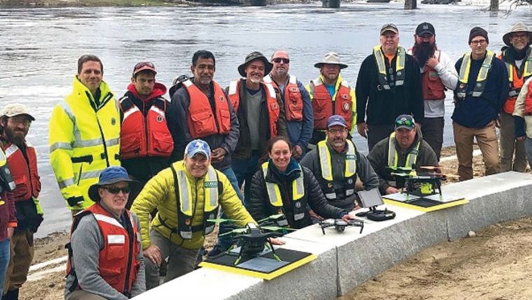
The US Geological Survey (USGS) and independent scientists gathered recently in Auburn, Maine, to evaluate the use of sensor-mounted unmanned aircraft systems (UAS), or drones, to gauge stream stage, velocity, bathymetry, and discharge. The technology is being evaluated and modelled to determine whether it will support the fast, accurate and safe measurement of rivers, especially when they are flooded or contain floating trees, ice or other debris.
Two Dozen Experts
Close to two dozen hydrologic, geospatial and scientific experts gathered in what has been dubbed the '2019 Aquatic Airshow' to assess this technology. They were led by John Fulton of the USGS Colorado Water Science Center, Jack Eggleston of the USGS Water Mission Area Hydrologic Remote Sensing Branch, and Joe Adams and Sandy Brosnahan of the USGS National UAS Project Office. The USGS Water Mission Area works with partners to monitor, assess, research and report on a wide range of water resources and conditions, including streamflow, groundwater, water quality, water use, and water availability.
Non-contact Sensors
The testing involved equipping drones with non-contact sensors, including ground-penetrating radar for measuring river depths, Doppler velocity radar, and cameras with velocimetric analysis for measuring water surface velocities and calculating mean-channel velocities; and high-resolution cameras for photogrammetric mapping of surface topography and vegetation structure. Team members from the USGS Water Science Centers in Colorado, New England, and Virginia collected ground-truth river monitoring data with acoustic Doppler current profilers deployed from a boat and multiple other surveying techniques to verify the accuracy of the drone-based stream data.
Pix4D Triangular Adjustment
Woolpert Chief Scientist Qassim Abdullah was one of two scientists from the private sector asked to participate in the Airshow. Abdullah has more than 40 years of experience in analytical photogrammetry, digital remote sensing, and civil and surveying engineering. For the event, Abdullah devised a process in which the data collected by the drones underwent Pix4D triangular adjustment to produce 3D models of the water surface and river edges to assist the modelling of river velocity using the drone-based doppler velocity radar and large-scale particle image velocimetry.
Public-private Partnership
USGS scientists are in the process of evaluating the data and modelling produced by this testing to conclude whether this technology will prove beneficial. Abdullah said the Airshow was an example of how a public-private partnership can work together to activate and elevate necessary, groundbreaking technologies to address worldwide issues.

Value staying current with hydrography?
Stay on the map with our expertly curated newsletters.
We provide educational insights, industry updates, and inspiring stories from the world of hydrography to help you learn, grow, and navigate your field with confidence. Don't miss out - subscribe today and ensure you're always informed, educated, and inspired by the latest in hydrographic technology and research.
Choose your newsletter(s)


