Women power NOAA hydrography
Navigating the field and reaching leadership positions
The role of women in hydrography is increasing worldwide. In 2022, NOAA participated in the international Empowering Women in Hydrography (EWH) programme initiated by Canada and the International Hydrographic Organization, by sponsoring three early career hydrographers for underway experience aboard NOAA hydrographic ships.
Selected from respondents to a global call for nominations, the three participants spent time aboard NOAA ships during the 2022 field season. Sub-Lieutenant Mercy Modupe Ogungbamila from the Nigerian Navy joined NOAA Ship Rainier from 5 to 15 July for ship and launch surveys in Guam and the Mariana Islands: “I was happy to participate in three survey teams which comprised seasoned survey technicians, scientists and NOAA Corps officers. This afforded the knowledge of various approaches to the survey as each team was tasked with different areas of Apra Harbor,” said Sub-Lt Ogungbamila. Chiaki Okada from the Hydrographic and Oceanographic Department, Japan Coast Guard, joined NOAA Ship Thomas Jefferson for ship and launch surveys from 25 July to 6 August in Lake Erie, one of North America’s Great Lakes. Chiaki came to the ship with deep-water mapping experience from the Japan Coast Guard, following her ocean mapping graduate fellowship experience at the Nippon Foundation/GEBCO Training Program at the Center for Coastal and Ocean Mapping/Joint Hydrographic Center (CCOM/JHC), University of New Hampshire (UNH). Firosa Tomohamat from Suriname’s Maritime Authority joined NOAA Ship Thomas Jefferson for launch and ship hydrography from 8 to 26 August, also in Lake Erie. In her log from the experience, Firosa noted: “…there were a lot of women with different roles aboard. It was a big inspiration and motivation for me….”
Like Firosa Tomohamat, NOAA is enthused by the success of the first year, and therefore plans to host women hydrographers similarly during the 2023 and 2024 field seasons.
Key hydrographic roles
NOAA is well-positioned to continue its leading role in the EWH programme, because women power NOAA hydrography as leaders in key hydrographic roles throughout the agency. A common factor for many of these outstanding women is their technical expertise in hydrography and ocean mapping developed at the NOAA-sponsored CCOM/JHC at the University of New Hampshire. The Graduate Programme in Ocean Mapping at UNH is recognized as a Category A education programme in hydrography by the FIG/IHO/ICA International Board on Standards of Competence for Hydrographic Surveyors and Nautical Cartographers.
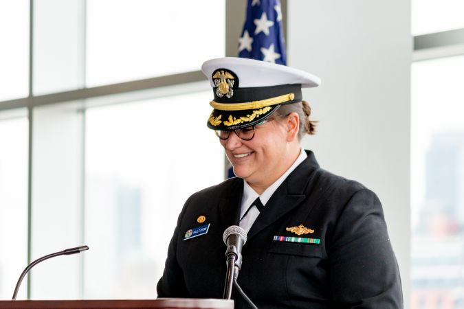
Commander Briana Hillstrom is an extensively experienced NOAA hydrographer who completed the Category A Master’s degree programme at UNH in 2014. She has been an NOAA Commissioned Corps Officer and hydrographer for over 19 years, with over nine of those years in sea assignments on all four of NOAA’s hydrographic ships – Rainier, Fairweather, Ferdinand R. Hassler and Thomas Jefferson – conducting hydrographic surveys on both coasts of the United States as well as the Gulf of Mexico, Caribbean and Artic; and commanding Ferdinand R. Hassler and Thomas Jefferson.
Cdr Hillstrom is the Chief of NOAA’s Hydrographic Surveys Division. In her current role, she leads the Office of Coast Survey’s hydrographic survey programme, with responsibility for planning, managing and reviewing hydrographic surveys from NOAA ships and contractors as well as checking volunteered, externally sourced data against quality-based specifications and standards for nautical charting and other value-added mapping products. Cdr Hillstrom is giving back to the hydrographic community and to hydrographic education by sharing her expertise as a member of the US Hydrographic Certification Board and by delivering guest lectures on hydrographic operations and careers to UNH’s new undergraduate ocean mapping class – taught by recent UNH Ocean Mapping PhD graduate Elizabeth Weidner – in the university’s Mechanical and Ocean Engineering department.
Several women in branch chief and team leader positions support Cdr Hillstrom in the Hydrographic Surveys Division. Christina Fandel, also a Category A programme graduate of the UNH programme, is chief of the division’s Operations Branch, overseeing teams with responsibility for setting hydrographic survey priorities, developing survey specifications and plans and overseeing the agency’s contract surveys. Before taking her present position, she was a leader in developing Coast Survey’s Hydro Health concept, which uses quantitative methods to establish surveying and mapping priorities for NOAA’s ships and contract surveys.
Modern hydrography powered by women
The Coast Survey hydrography programme has embarked on a major overhaul in the management of bathymetry for the electronic navigation chart. This overhaul is built around the National Bathymetric Source (NBS), intended to be the authoritative bathymetry for nautical charting in the United States. Instead of compiling charts from individual hydrographic surveys, and resolving junction, overlap, datum and supersession issues during chart compilation, the bathymetry for charting would come from a single unified and comprehensive digital elevation model built from the best available source data. Katrina Wyllie, another NOAA UNH Category A graduate, developed the criteria for establishing the most reliable source data and is the team leader of the group in the Hydrographic Surveys Division building and maintains the NBS.
Lieutenant Airlie Pickett, a NOAA Corps hydrographer with operational hydrography experience on NOAA Ship Rainier and NOAA Ship Thomas Jefferson and a recent scientific ocean mapping cruise on the Ocean Exploration Trust E/V Nautilus, is one year into the intensive three-year CCOM/JHC Category A Master’s in Ocean Mapping programme. Her research at UNH draws on experience with UNH’s DriX uncrewed surface vessel (USV) on the Nautilus cruise and will focus on developing protocols for incorporating multibeam-equipped USVs into the daily operations of NOAA hydrographic survey ships and shore-based navigation response teams.
Coast Survey hydrography, with its home in NOAA’s National Ocean Service, focuses mainly on surveys in water depths critical to safe navigation and coastal resilience. NOAA Ocean Exploration, part of NOAA Research, carries out ocean mapping and exploration projects in deeper waters of the United States and in international waters.
Rachel Medley is chief of the Expeditions and Exploration Division in NOAA Ocean Exploration, providing guidance and strategic direction to explore and enhance the public’s knowledge in the marine environment. Before joining NOAA Ocean Exploration, she worked in NOAA’s Coast Survey for 12 years, gaining expertise in charting, hydrographic surveying and outreach to communicate NOAA’s navigation products and services. At Coast Survey, she completed the Category A Master’s degree in Ocean Mapping at UNH in 2009. The Expeditions and Exploration Division focuses on at-sea mapping and exploration operations using a variety of platforms, sensors and technologies. Her position requires proactive engagement to develop and advance strategic partnerships to achieve a broad impact on the hydrographic and scientific communities, domestically and internationally. “As a leader in NOAA, I am pleased to support and foster an inclusive workplace through the development of others, facilitating cooperation and teamwork, supporting a safe, secure and productive workplace and enhancing professional development.”
Working with Rachel, Shannon Hoy is the lead expedition coordinator in the Expeditions and Exploration Division. She completed the UNH Category A Master’s in Ocean Mapping in the spring of 2022. In her role as lead expedition coordinator, she is responsible for planning, executing and evaluating NOAA Ocean Exploration’s multidisciplinary expeditions. A recent example of the impact she is having on the hydrographic community is her collaboration on the development of the Ocean Mapping Community Wiki with colleagues representing academia, industry and government.
These and other outstanding NOAA women are powering NOAA hydrography with their technical expertise and are playing leading roles across the agency’s hydrographic and ocean mapping programmes.

Value staying current with hydrography?
Stay on the map with our expertly curated newsletters.
We provide educational insights, industry updates, and inspiring stories from the world of hydrography to help you learn, grow, and navigate your field with confidence. Don't miss out - subscribe today and ensure you're always informed, educated, and inspired by the latest in hydrographic technology and research.
Choose your newsletter(s)


