World War II Charting: The Pacific War
In late November 1941, the USS Sumner (AG-32) proceeded to Pearl Harbor and joined the United States Pacific Fleet. This ship had begun its career as the USS Bushnell, a submarine tender, but had been ordered to hydrographic duty and renamed in 1937. It was moored at the Submarine Base at Pearl Harbor on the morning of 7 December 1941.
At approximately 07:55 local time, bombs began raining down on Hawaiian airfields and the battleships moored in the harbour. The Sumner went to general quarters at 07:59 and four minutes later shot down an attacking plane. Lieutenant Commander I. W. Truitt, commanding officer of the Sumner, in his after action report stated: “0803 Torpedo plane passed close aboard, within about 100 yards of Sumner’s stern, on W course, altitude about 75 feet, leveled off for launching torpedo at BB’s. Plane continued on its course until it was about 300 yards distant from Sumner’s stern, when it was struck by a direct hit from Sumner’s No. 3 A.A. gun. Plane’s gasoline tank believed ignited, as plane immediately disintegrated in flames and sank in fragments. Torpedo believed sunk without exploding; Gun Captain, Campbell, H.L., BM2c, and Pinter, Pastor, J.M., MM2c, are believed worthy of special commendation for their coolness and promptness in bringing their gun into action and in scoring a hit on the plane.” Thus, hydrographers of the US Navy were among the first to engage the enemy in the opening minutes of US involvement in World War II.
The Sumner (re-designated AGS-5) was the primary hydrographic survey vessel in the Pacific Fleet for much of the next year and, beginning in January 1942, commenced surveys in the southwest Pacific at potential fleet bases including Tongatabu, Nandi Island and Samoa. In May, the ship transported marines to Wallis Island and then commenced survey operations at New Caledonia, in the New Hebrides, and finished the year surveying at Tulagi, Solomon Islands. However, the Pacific theatre of operations extended from the Aleutian Islands to the Solomon Islands and from the Panama Canal to Australia, nearly one sixth of the surface of the Earth. It was dotted by numerous islands and reefs, some of which had not been surveyed since the days of James Cook and Charles Wilkes. Accordingly, more survey ships were needed. To fill this need, the Pathfinder (AGS-1), Oceanographer (AGS-3) and Hydrographer (AGS-2) were transferred from the Coast and Geodetic Survey (C&GS) to the Navy in 1942 and 1943 with their officer complements and much of their crews; the navy hydrographic ship USS Bowditch (AGS-4) was transferred from the Atlantic to the Pacific in 1943 and assigned a contingent of C&GS officers; and a number of new survey ships that were either built or converted from minesweepers and other small ships joined the hydrographic forces in 1944 and 1945. Collectively, these vessels compiled a remarkable record and conducted literally hundreds of surveys and reconnaissances for the US Pacific Fleet. A few of the larger ships had their own printing facilities; thus, the hydrographic units were surveyors, compilers and printers of charts. Although not assigned to survey vessels, an additional source of United States hydrographic capability were the Coast and Geodetic Survey officers assigned to Army Engineer Boat and Shore Regiments. These will be discussed in a future article.
There was a wide range of duties for the hydrographic ships, including classical wide-area hydrographic surveys designed to increase naval tactical operating areas and improve harbours and anchorages. There were also amphibious assault surveys, which were classified into pre-invasion surveys, assault surveys and post-assault surveys. Pre-invasion surveys were conducted off hostile shores and were often conducted by detached parties at night from rubber boats with hydrographers using lead-lines, luminous compasses and pressure gauges for tidal observations. The nature of this work required that most data acquired be committed to memory as there was little opportunity to properly record depth and position information. The second class of survey work was the assault survey that required, in general, such activities as: 1) the location and marking of obstructions and hazards in the approaches to the landing beaches; 2) close development of the zone between debarkation of landing craft and high tide line on beach; 3) development of anchorage areas including layout of berths by number and establishment of lane markers; 4) small craft emergency refuge anchorages and beaching area; 5) anti-torpedo net locations; 6) blasting, surveying and marking small craft channels; 7) tanker moorings for fuel off-loading lines; 8) establishment and location of approach and night station-keeping lights; and 9) wire-dragging seaplane anchorages, runways and constricted traffic lanes. The post-invasion surveys that followed the initial assaults and major combat operations were more akin to standard peacetime surveys of various islands and harbours, although even these surveys were often subjected to air attack.
The dangers of the pre-invasion and assault surveys were quite real. The Pathfinder was subjected to over 50 bombing raids while, in the Guadalcanal area, it shot down two enemy aircraft in Tulagi Harbor, and then, later in the war, was crashed by a kamikaze aircraft at Okinawa with the loss of one member of the crew. The small survey ship Dutton was also crashed by a kamikaze at Okinawa on 27 May 1945. The resulting explosion carried away part of the bridge, killed one crewman, and holed the ship, fortunately above the waterline. Artillery was also a hazard. During survey operations at Iwo Jima, the Sumner was hit by shore-based shellfire resulting in the death of one crew member and wounding of three more. Fortunately, the shell failed to explode and there were no further casualties. Shore parties and small boat operations were not immune from attack. Coast surveyor Ernie Stohsner described an attack at Guadalcanal: “The ship was out doing hydrography between Florida and Guadalcanal Islands at the time. I had the wire drag out and was on the 30-foot guide launch about two miles east of the ship. Our first knowledge of the actual attack was a geyser of water next to the Pathfinder caused by the near-miss of a dive bomber. A number of planes pealed out of the sun at the same time attacking aircraft in the vicinity of the Pathfinder. One of these escaped fire from the ships and came directly towards us and commenced strafing. All personnel topside dove over the side. The recorder, dragmaster and myself were at the plotting table below and did not have time to get out. Six machine gun slugs hit the launch up forward within a few feet of us....”
Former crew member, A. F. Funk, wrote a letter to Captain William Scaife, the wartime commanding officer of the Hydrographer, in 1952 recalling an incident during operations on Guam: “I also remember you bringing a jeep and getting us out of a tight spot on Guam when we were under sniper fire. It was on the high cliff to the right of the channel going into the harbour. Groves and I were at that station as well as an officer and a radioman with a walkie talkie. There was another party over on the jetty and the Hydro was running lines in the channel. When the rifle fire put us to cover, we called you by radio and you came by jeep and picked us up. One of the Marine patrols shot a Jap Lieutenant sniper just a little while after we left. I can remember that because one of the two officers that came aboard the day before was with us and he almost went over that cliff when one of the bullets whistled past his ear.”
Although there were many individual and collective feats of valour within the hydrographic survey crews of the United States fleet in World War II, it was not until after the battle of Tarawa that a unified hydrographic survey command emerged. A lack of understanding of both tides and hydrography led to many casualties and near disaster for this first large amphibious operation of the central Pacific. Within a few weeks of the Tarawa operation, Lieutenant Ira Sanders was detached from the Bowditch and assigned to the staff of the commander amphibious forces, United States Pacific Fleet. His first job was to plan and execute surveys at Kwajalein and Roi-Namur during Turner’s second major assault. For this job he also brought Ernie Stohsner and John Tribble from the Bowditch on a temporary duty basis. They were assigned to mobile hydrographic units, which accompanied the initial landings at ‘H’ hour. Stohsner was on an LCC that was used as a sounding boat while Tribble was attached to small vessels, which were used for wire drag. Sanders acted as operations officer coordinating the activities of the hydrographic parties. By D+2, channels and anchorages had been sounded and a chart was distributed to battleships and cruisers as they entered the lagoon to anchor.
Commander Sanders commanded mobile hydrographic units at Saipan and Tinian and was awarded the Bronze Star Medal for directing hydrographic units charting enemy held waters in the face of active and determined opposition. Because of surveys conducted under his direction, heavier vessels were able to take safer and more advantageous positions, which allowed them to take a more active part in defeating the enemy. During the Iwo Jima and Okinawa campaigns, Sanders was responsible for all hydrographic surveys needed for the plans and operations of the US Pacific Fleet. His staff responsibility included control of the survey ships Bowditch, Sumner, Hydrographer and Pathfinder as well as the Hydrographic Survey Group, which was made up of eight smaller vessels such as the USS Littlehales. This small ship conducted clandestine surveys of Iwo Jima prior to the amphibious landings. Commander Sanders was awarded a Gold Star in lieu of a second Bronze Star Medal for personally supervising the surveys off Iwo Jima and Okinawa “in the face of intense hostile fire and heavy aerial attacks by the enemy.” The citation continues that Commander Sanders “contributed materially to the success of these two major operations.”
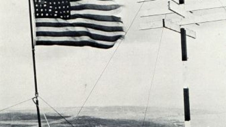
As a footnote to the Iwo Jima campaign, it is noted that a shore party from the USS Sumner placed a hydrographic signal on the top of Mount Suribachi shortly after the iconic flag raising by the United States Marines on its summit. The placing of this signal on Suribachi is a testimony to the quiet courage of all those hydrographers who fought the Second World War with sextant, lead-line and fathometer. Their work, often under fire, was crucial to the movement of men and material throughout the Pacific on the road to Tokyo. They did their job and did it well.

Value staying current with hydrography?
Stay on the map with our expertly curated newsletters.
We provide educational insights, industry updates, and inspiring stories from the world of hydrography to help you learn, grow, and navigate your field with confidence. Don't miss out - subscribe today and ensure you're always informed, educated, and inspired by the latest in hydrographic technology and research.
Choose your newsletter(s)


