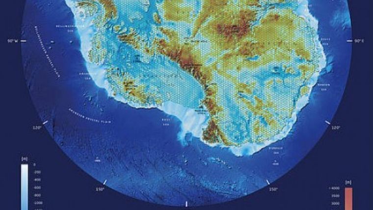
3D Map of Antarctica
The Alfred Wegener Institute, Helmholtz Centre for Polar and Marine Research (AWI) and the TU Dresden’s Institute for Cartography (Germany) are presenting their joint three-dimensional map of the Antarctic continent and the seafloor of the Southern Ocean at this year’s International Cartographic Conference in Rio de Janeiro, Brazil. For the first time, the map simultaneously shows viewers three geographic layers: the Antarctic ice sheet, the land masses it conceals and the surrounding underwater landscape.
The map covers a total depth range of over 12,000 metres: from the ice sheet, down to the depths of the surrounding Southern Ocean. The so-called lenticular print is a novelty; the scientists portrayed Antarctic ice sheet, which is up to 4,800 metres thick, as a honeycombed grid structure, allowing viewers to see through it to the mountain ranges below. Another new feature is that the scope of depth includes the entire z-axis. In the past, it was only possible to show deeper areas or, in the case of world maps, the corresponding ocean regions but without any depth, according to Lars Radig.
International Bathymetric Chart of the Southern Ocean
One major source of data for the new 3D visualisation was the International Bathymetric Chart of the Southern Ocean (IBCSO), a digital representation of the entire Antarctic seafloor south of the 60th parallel that was released in 2013 under the auspices of the Alfred Wegener Institute. The second key source was provided by Bedmap2, a three-dimensional digital map of Antarctica that depicts the bedrock under the Antarctic ice sheet. The new True-3D visualisation is the first of its kind to combine the two datasets.
Image: 3D Visualisation of the Antarctic (Photo: Lars Radig).


