4D Surveying Above and Below Water
The Miami Port and Terminal Technology USA 2012 4th international conference and exhibition saw the launch of the industry's first custom-designed 4D (x,y,z + time) land and marine survey vessel. Following the success of its Dynascan mobile mapping system (the world's first truly portable Lidar system) and the increasing market demand for a combined multi-beam sonar and Lidar data collection system, Measurement Devices has introduced the industry's first custom-designed and built 4D data collection hydrographic survey vessel, the DYNASCAN-1.
The DYNASCAN-1 is a trailerable 30 foot LOA ‘V' bottom aluminium work boat, which has been designed and built for shallow water survey operations. The vessel is fitted with the latest precise positioning, data collection and processing systems and is capable of simultaneously acquiring 360° field of view, high-precision 4D (X,Y,Z and time) data from below and above the surface of inshore and inland waterways, in real time, and referenced to a single common reference point in space and time.
Precise Positioning is provided by dual GNSS receivers. Differential GPS and GLONASS corrections are provided to the onboard GNSS receivers by Radio (RTK), Wireless Internet (VRS) or via satellite service (HP DGPS). The dual GNSS receivers also provide accurate heading information.
Accurate Heading is supplied by the onboard angular rate sensors and accelerometers which form an integral part of the MDL IMU 5000 Inertial Motion Unit (IMU). Heading and rate of turn measurements are augmented by the integral GNSS GPS heading system.
Motion Reference for the vessel (Pitch, Roll, Yaw offset and Heave) is provided by the onboard MDL IMU 5000 Inertial Motion Unit (IMU) at rates of up to 200Hz. In order to optimise the IMU performance, the IMU has been installed at the precise centre of gravity (COG) of the vessel. The COG of the IMU itself is the zero reference point for all of the onboard positioning and survey sensors.
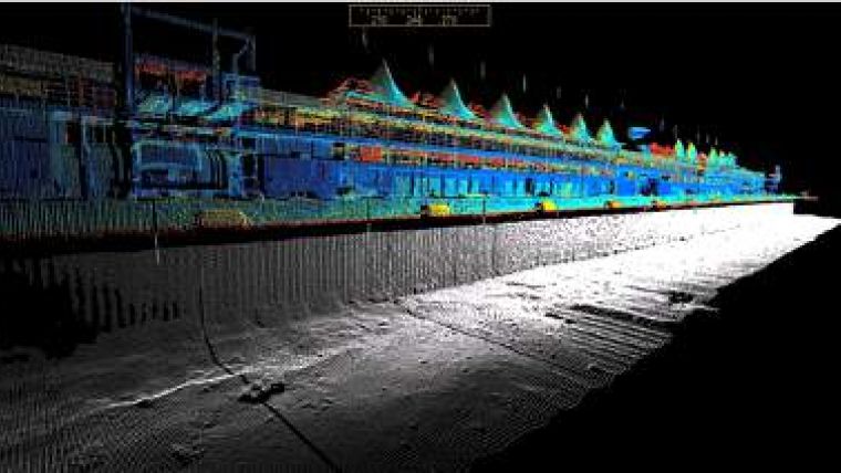
Three MDL marine-grade SLM Lidar systems have been configured for both medium range (1 to 150 metres) and long range (1 to 500 metre) operations in all weather conditions.
Two SLM-150 metre range lasers are mounted port and starboard at the rear of the instrument cabin at 45° in both pitch and heading, designed specifically to gather detailed data of ports, harbours, bridges, dams and other structures at medium range. A third SML-500 metre unit is mounted normally amidships at the front of the instrument cabin, ideally placed for longer distance Lidar operations such as coastlines, beaches and high structures. The three SLM's are all precisely synchronised and can be used concurrently to gather medium and long range data in a single pass at rates of up to 108,000 points per second.
Multi-beam SONAR data is gathered a multi-beam swath sonar system. The system operates at user selectable frequencies between 200KHz to 400KHz making it ideal for all water and seabed conditions.
Data acquisition is controlled by the QPS QINSy (Quality Integrated Navigation System) software suite. QINSy is the industry's leading real-time hydrographic data acquisition, navigation, processing and Quality Control (QC) software package.
The suite of applications can be used for various types of surveys, ranging from simple single bathymetry surveys up to complex dredging or offshore construction operations. On the DYNASCAN-1, the system is configured to acquire and QC the data from all of the onboard survey and positioning systems in real-time.
The DYANSCAN-1 has been designed specifically for inshore and inland waterways and will be ideally suited for 4D data acquisition in a number of market sectors, including but not limited to surveys of dams and walls, surveys ports and harbours, inland waterway surveys, coastline surveys, environmental assessment and dredging surveys.


