Arctic Rescue
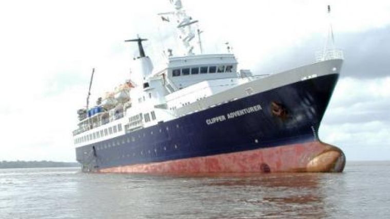
A team of University of New Brunswick researchers played a vital role in the recent rescue of a cruise ship stranded in the Arctic Ocean. The researchers, part of UNB's Ocean Mapping Group, helped map a safe course for the CCGS Amundsen, a Canadian research icebreaker that can also serve as a rescue vessel. The Amundsen was the closest vessel to the MV Clipper Adventurer, which ran aground last Friday on a voyage from Port Epworth to Kugluktuk, Nunavut.
The research ship had to steam more than 500 kilometres from the Beaufort Sea to reach the MV Clipper Adventurer in the Coronation Gulf. According to UNB professor John Hughes Clarke, head of the university's Ocean Mapping Group, the cruise ship effectively ran into an underwater cliff and had they been just a few ship lengths to the east or west they would have missed it.
The UNB researchers had to make sure that the Amundsen didn't meet the same fate. UNB's Doug Cartwright and Ian Church, who are leading the survey work on the Amundsen, used the ship's multi-beam sonar system to carefully survey the seabed along the approach to the stricken vessel. When Amundsen got closer to the stranded cruise ship, the researchers used a smaller multibeam sonar system on the research ship's barge to safely guide the vessel.
Church also did a three-dimensional survey of the area immediately around the grounded cruise ship using the barge.
The Canadian Arctic Archipelago, says Hughes Clarke, remains poorly charted. While there are safe shipping lanes in the area, receding ice in recent years has made it possible for ships to venture into parts of the Arctic that were never before accessible by water. Many cruise ships are heading into riskier areas, says Hughes Clarke. "The problem is cruise ships want to go off the safe shipping lanes where there is more dramatic topography or stunning wildlife," he says.
The only surveys done in many of those areas were from a helicopter that would land on the ice every six kilometers or so to collect data, mostly about the depth of the water. The area that the cruise line went aground in, most of the surveys were done by helicopter and according to Clarke, the measurements are accurate, to a point. "It's accurate, but imagine taking an elevation measurement in Fredericton and then in New Maryland and not notice the crest of the hill between the two." Hughes Clarke says that contrary to earlier media reports, the rock that the cruise ship ran aground on was a known hazard. The hazard had been reported in a Coast Guard notice to shipping in 2007, he says.
The surveys done by the UNB researchers are now being used by other Coast Guard ships assisting with the recovery of the cruise ship.
There are five UNB staff and nine graduate students within the Ocean Mapping Group. Roughly half of the students are Canadian, while others come from abroad including naval officers from Spain, Portugal, Brazil and Taiwan.
As engineers, the UNB contingent within the ArcticNet consortium is responsible for designing and running all the seabed surveying as well as developing new software and methods for advancing the technology.
The Ocean Mapping Group has processed and handed over all survey information pertaining to the grounding to the Canadian Hydrographic Service, who will be conducting additional surveys.
The Amundsen is currently underway back to the Beaufort Sea where she will be resuming her scheduled scientific seabed survey operations, says Hughes Clarke. It's important work, for shipping safety and for helping other industries such as the energy sector, that are exploring safe areas of the arctic that could be important for accessing oil and gas reserves. "It's exciting work. We're operating in areas that have never been ice free before."


