Bathymetry Model of the English Channel
SeaZone took a major step forward in December 2009 towards its aim to create a high-resolution and accurate bathymetry model of the UK Continental Shelf by completing the first phase of its Bathymetry Improvement Programme for the northern English Channel between South Foreland and Land's End. The new bathymetry model will become a core reference dataset in SeaZone's digital marine mapping product, HydroSpatial.
With increasing pressure on the marine environment and the requirement to maximise value from existing public sector information holdings, the new model in particular and HydroSpatial generally are already proving to be important tools to support offshore renewable energy development, marine planning and policy making. The bathymetry model, believed to be the first of its kind, is created from ‘best available' digital survey bathymetry data from a variety of different sources. It is being used by British Geology Survey to improve our understanding of sea bed geology and by Cefas (and others) as input to habitat mapping.
SeaZone has spent the past three years gathering and digitising data, capturing over 400 surveys to create this unique database of the UK's underwater terrain. The data represents the most detailed water depth data available, either from modern multi-beam surveys or single beam surveys dating back to 1970. All of the data used in the work has been collected to the IHO's International Survey Standard, S-44, and quality controlled at the UK Hydrographic Office or another competent authority. By using survey data as input, the new model is more accurate than depth data displayed on traditional navigational charts, which is widely known to be coarser in resolution and conservative in depth.
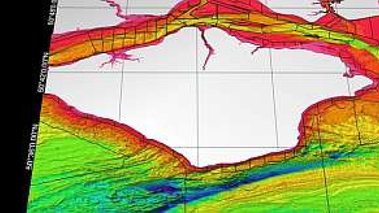
The de-confliction work separates the many overlapping surveys against each other based on a number of rules or attributes, most importantly survey age, survey type and sounding density. The result is a set of modified survey extents which are clipped against one another to keep the best available data in full, creating a seamless surface of depth soundings. The clipped survey extents are used to label each sounding in the Oracle database, with an active or inactive identifier, so that only the active soundings from each survey are used as input into the bathymetric model. The survey extents also form a meta layer, similar to the ‘source data diagram' on an Admiralty Chart, which is used to identify the age and provenance of the data used in the model. An example of these clipped survey extents in the Isle of Wight area is shown with this release.
Acknowledgements
SeaZone is pleased to acknowledge the Civil Hydrography Programme of the Maritime and Coastguard Agency (MCA), the Channel Coastal Observatory, the Port of London Authority and various other ports, harbours and third parties in contributing survey data to this programme. The modelling work is supported by a contract from CEFAS (Centre for Environment, Fisheries and Aquaculture Science) where the results are being used to undertake habitat mapping work in the English Channel on behalf of Defra.


