Boaty McBoatface to Monitor Marine Environment in the North Sea
The National Oceanography Centre (NOC) has begun conducting research with robot submarine Boaty McBoatface on end-of-life oil fields off the coast of the Shetland Islands to help monitor and protect the marine environment in the North Sea and to support the industry transition towards its net-zero targets.
The underwater robot will explore several oil and gas structures, including NW Hutton and Miller as well as the Braemar Pockmarks Marine Protected Area, revolutionizing the way in which marine surveys are undertaken.
Monitoring for Decommissioning Oil and Gas Structures
The Autonomous Techniques for infraStructure Ecological Assessment (AT-SEA) project, led by the NOC, will trial the concept of using submarines such as Boaty McBoatface for high-tech, low-impact monitoring to pick up any potential environmental impacts at these industrial sites. This may eventually replace the current approach to environmental monitoring for decommissioning that requires dedicated ships and teams of people offshore.
The NOC’s AT-SEA project will take place over a ten-day period using state-of-the-art technology, with the aim to provide future-proof solutions for the oil industry focusing on the need to reach better net-zero targets. The robots will gather data on the water, pollutants and currents, and take images of the sea floor. The team will test whether these robotic systems can gather equivalent information to the surveys currently done using ships. In doing so, emissions, risks and the cost of these operations will be significantly reduced in the future, thanks to the automated technology being developed at the NOC.
Project lead for AT-SEA, Dr Daniel Jones from the NOC, explained: “The overall goal of the project is to improve the environmental protection of the North Sea at a reduced cost and impact to the environment. We aim to demonstrate how this leading robotic technology from the NOC could be used worldwide to support this crucial ocean monitoring.”
The Advantages of Autonomous Submarines
There are currently thousands of oil and gas structures in the sea that are approaching the end of their lives – in UK waters alone there are nearly 500. As part of decommissioning, they typically need to be removed and the environment returned to a safe state. To ensure that no harmful effects occur to the marine environment, decommissioning operations need to be supported by an environmental assessment and subsequent monitoring.
Dr Jones continued: “This technology has the potential to change the way in which marine surveys are carried out in the future. Autonomous submarines could offer many advantages over current approaches; improving the quality and quantity of environmental information while cutting the cost and environmental impact for a survey ship and its crew. The AT-SEA project will test this concept in UK waters and carry out the first fully autonomous environmental assessment of multiple decommissioning sites.”
Ocean robots, which use computer systems to carry out survey missions by themselves, are regularly used by scientists for environmental assessments as they collect very high-quality data quickly. Additionally, using autonomous underwater vehicles is a low carbon solution to the issues with environmental monitoring that will bring substantial reductions in emissions of greenhouse gases over the traditional approaches of using ships. Recent technological developments have cut the cost and expanded the range of these robots to thousands of kilometres, making it possible for long-range assessments of multiple sites to be undertaken with a robot that is launched from the shore.
Mapping the Seafloor
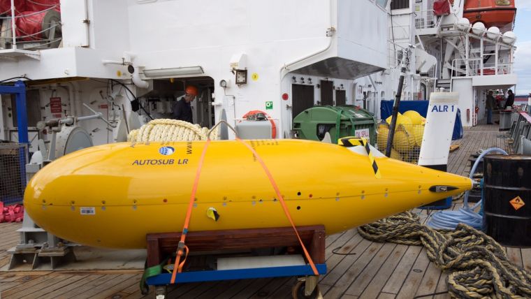
The Autosub Long-Range ocean robot submarine, otherwise known as Boaty McBoatface, will be launched from the shore in Shetland, to carry out environmental assessments at two decommissioning sites in the northern North Sea. The robot will then return around ten days later with the detailed survey information onboard. The robot will take photographs of the seabed, which will be automatically stitched together to make a map of the seafloor, the structures present and the animals that live there. Established sensor systems will measure a range of properties of the water, including the presence of hydrocarbons. As well as the decommissioned sites, the robot will visit a special marine protected area that is known to have natural leaks of gas, to check that the robot can reliably detect a leak should one occur in the future.
On return to shore, the project team will examine all of the data obtained and compare it to that gathered using standard survey ship methods. Additionally, the team will test if the same environmental trends can be identified from both datasets to determine whether the automated approach would be a suitable replacement for standard survey ship operations.


