CEE JET Hydrographic Survey Jet Ski Delivered for Gold Coast Beach Surveys
After learning about the prospect of using a jet ski with a singlebeam echosounder to conduct bathymetric surveys in a fraction of the time, the Gold Coast council in Australia purchased its first CEE JET hydrographic survey system from CEE HydroSystems. With a survey-grade CEESCOPE singlebeam echosounder, RTK GNSS, on-board computer for data collection and HYPACK software, the CEE JET allows collection of high-quality bathymetry data in the often substantial area of the surf zone.
Australia's Gold Coast stretches along 57 kilometres (35 miles) of coastline and the region is home to over half a million people. In order to maintain the economic engine behind the growth of the Gold Coast region, management activities include dredging, sand bypassing, sand nourishment and the construction of protection structures. The council's extensive monitoring of beaches and of coastal patterns and the data gathered over many years provide valuable information about coastal processes and their impact on the coastline; the oldest Gold Coast measurement transect has been continuously surveyed for the past 60 years.
Laborious and Time-consuming Survey
One survey method used by the Gold Coast council hydrographic section has changed little over this time. Levelling measurements are used to obtain surf zone bathymetry data to map the movement of sand, particularly before and after large tropical storms that have a potentially enormous impact on sand distribution. First, a 20m spaced grid is pegged out on the beach to guide the survey crew along the transects. Then, a swimmer with a level rod is dropped into the water from a jet ski. The swimmer uses the rod to identify the bottom along the transect and a surveyor on the shore with a total station measures the elevation of the rod. When one discrete measurement is recorded, the rod is moved to the next point along the transect. The method is time-consuming, laborious, and includes substantial disruption to the beach activities. Surfing in the survey area is affected, and the beach markers that are laid out are a nuisance. Overall, it takes the council 6 weeks to obtain their required measurements using this methodology.
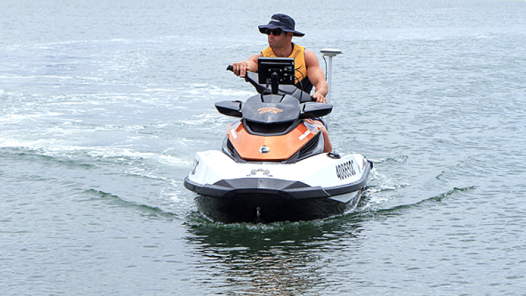
More Data in Less Time
The CEE JET is a standard Sea-Doo personal watercraft (PWC), modified at the CEE HydroSystems factory with concealed internal cabling and custom equipment mounting brackets. As the CEESCOPE is a small form factor echo sounder that contains both the RTK GNSS receiver and the UHF radio modem for communication with the local RTK base station, it can be installed inside the small waterproof compartment available on the PWC. A high-grade waterproof display mounted on the handlebars and joystick mouse allows the surveyor to collect, view and manage bathymetry measurements along the pre-defined survey transect lines. With soundings collected at 20Hz, the council will benefit from the ability to collect significantly more data on their surveys - and in a fraction of the time. The depth soundings are converted into an elevation above the survey datum by using RTK GNSS tide correction. The accurate GNSS antenna height is continuously recorded in HYPACK and the sounding depths are automatically and instantaneously translated into bottom elevation, giving the Gold Coast Council a sonar-derived data set consistent with their previous surveys.


