Collating European Marine Data
The European Commission has concluded service contracts for creating pilot components of the European Marine Observation and Data Network (EMODnet). The overall objective is to create pilots to migrate fragmented and inaccessible marine data into interoperable, continuous and publicly available data streams for complete maritime basins. The EMODnet project is also aiming at compiling a complete overview of multi-beam and single-beam surveys for Europe's maritime basins as managed by public and private sources.
These references will be included in the metadata discovery service. So far the inventory covers more than 7,000 surveys from public authorities, hydrographic services and research institutes, but private sector entries are still lacking.
Holders of additional bathymetric survey data from public and private sector are called to include their survey metadata. Increased participation of the private sector will make it possible to assess the present coverage of European waters with high resolution surveys and to estimate the effort required to complete gaps in coverage by new surveys which is a key question for the EU. Please contact the EMODnet team using the feedback button at the portal. Also, feedback on the present services and products for improving the portal is welcomed.
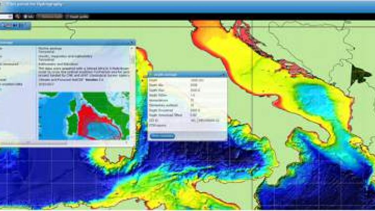
The EMODnet-Hydrography portal development started in June 2009 and provides a range of options for browsing and downloading new Digital Terrain Models (DTM) for a large part of the European seas free of charge. The downloadable tiles are available in a number of formats, including the Fledermaus SD format for 3D viewing. The EMODnet digital bathymetry, with a grid size of 0,25 * 0,25 minutes, has been produced from quality controlled bathymetric survey data and aggregated bathymetry data sets collated from public and private organizations. Further refinement is underway, also by gathering additional survey data sets, and will result in new releases in time.
The portal also includes a metadata discovery service, by adopting the EU SeaDataNet CDI standard, that provides useful information about the background survey data used for the DTMs, their access restrictions, originators and distributors. This way the portal provides originators and managers of hydrographic data sets an attractive shop window for promoting their data sets to potential users, without losing control.


