Data Behind MH370 Search: Phase One Released
Geoscience Australia has released the sea floor mapping data collected during the first phase of the search for missing Malaysia Airlines flight MH370. The search for MH370 involved collecting large volumes of data in a remote part of the southern Indian Ocean. The search was conducted in two phases - the first phase was a survey to collect bathymetry data, or data of the sea floor topography, to develop maps of the sea floor in the search area. These maps were used to safely guide the second phase of the search, the underwater search.
Australia, with the support of Malaysia and the People's Republic of China, committed to releasing the data acquired during the two phases of the search to the public. Geoscience Australia is delivering the data on behalf of the Australian Government, with Phase One released today and Phase Two being released in mid-2018.
Vast Quantities of Data
According to the Chief of Geoscience Australia's Environmental Geoscience Division, Dr Stuart Minchin, the release of the data is especially significant given the vast quantities that were collected and processed throughout the search. Geoscience Australia has been involved in the search for the missing aircraft since early on. With more than 50 years' experience in marine surveys, Geoscience Australia provided advice to the Australian Transport Safety Bureau on procurement and planning for the search for MH370. They have also been responsible for the processing and analysis of the two phases of search data.
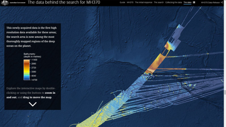
Geoscience Australia has launched an interactive story map for users to learn more about the search for MH370 and to explore the Phase One data.
Survey Data Valuable for Scientific Community
It is estimated that only 10-15% of the world's oceans have been surveyed with the kind of technology used in the search for MH370, making this remote part of the Indian Ocean among the most thoroughly-mapped regions of the deep ocean on the planet. So this data is unique both because of the remote location of the search area, and because of the sheer scale of the area surveyed, according to Mr Minchin.
The data was collected for the sole purpose of locating the missing aircraft, but, as it is some of the first high resolution data of this region, it will also be valuable to the scientific community. The Phase One data shows the sea floor in never-before-seen detail, revealing ridges six kilometres wide and 15 kilometres long that rise 1500 metres above the sea floor, and fault valleys 1200 metres deep and five kilometres wide.
This data will contribute to a greater understanding of the geology of the deep ocean and the complex processes that occur there; it will be important for a range of future scientific research, including oceanographic and habitat modelling.
It was important for Geoscience Australia to deliver this data so that it is accessible to a range of users. The interactive story map for the public allows you to explore the data and learn more about the search for MH370. For more experienced users, the Phase One data is available through two data visualisation platforms on Geoscience Australia’s website to interrogate the data in different ways. The National Computational Infrastructure Australia is hosting the full 'raw' data for experts to download.


