Expanding the Knowledge of Arctic Ocean Bathymetry
Scientists from DTU Space, Denmark’s national space research institute, have published a paper that reveals the first Arctic bathymetry map using marine gravity. Previously, the knowledge of the depth and shape of the Arctic Ocean floor (its bathymetry) has been insufficient. Owing to year-round sea-ice coverage and the cost of research in this remote region, much of the Arctic Ocean’s bathymetry has remained a mystery, until now, according to a recent publication by the European Space Agency, which can be found at www.easy.int.
Bathymetry maps are crucial for studying ocean dynamics, currents and tides, as well as for ship safety. Several campaigns to map seafloor bathymetry through ship soundings have been proposed, but only small fractions of the Arctic Ocean have ever been covered.
Gravitational Pull
The surface of the ocean is not flat. Because of gravitational pull, the height of the ocean surface mimics the rise and fall of the ocean floor. Areas of greater mass such as underwater mountains have a higher gravity and therefore attract more water creating a rise in the sea surface.
Fine-tuning the relationship between bathymetry and gravity in the Arctic Ocean has enabled scientists to calculate seafloor bathymetry from satellite gravity measurements. By using ERS-1 and ERS-2, Envisat and seven years of CryoSat data, an altimetric gravity model has been developed by DTU. This has been combined with the existing IBCAO bathymetry map to create a new and improved hybrid bathymetry map of the Arctic Ocean,
High Spatial Resolution
CryoSat was originally launched to measure sea-ice thickness, but data from the Earth-observing satellite has been exploited for other studies. Carrying a radar altimeter, the satellite can sense the gravity field at the ocean surface, so that seafloor characteristics are revealed – allowing it to map the global marine gravity field at a high spatial resolution.
“The existing IBCAO bathymetry map of the Arctic Ocean is based purely on ship soundings and assisted by digital depth contours. Combining the IBCAO bathymetry with altimetry-derived marine gravity has resulted in a more accurate bathymetry map of the Arctic,” said Ole Baltazar Andersen from DTU Space.
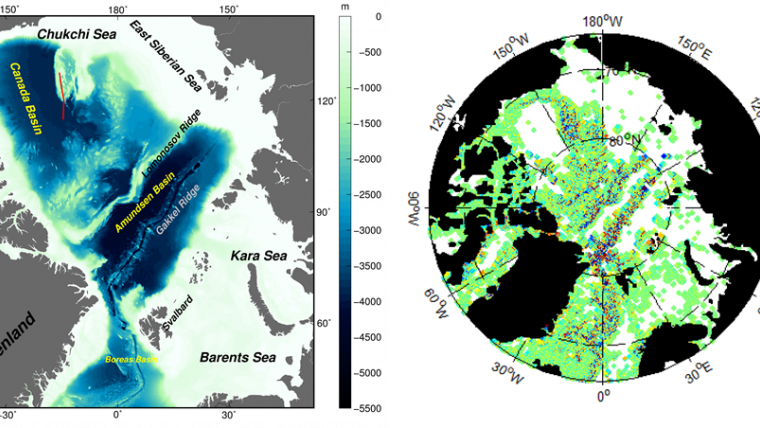
Caption: Existing bathymetry map of the Arctic Ocean visible on the left, including the location of the Chukchi Sea and a ship sounding survey crossing the Chukchi Cap (red line). The figure to the right shows the difference between the predicted bathymetry and IBCAO. Only locations where bathymetry could be determined from altimetry are shown in the left figure (courtesy DTU Space).
More information: www.easy.int


