Expedition Team Reveals Deepest Points in Indian and Southern Oceans
As part of the Five Deeps Expedition team, scientists from the British Geological Survey have surveyed in detail the deepest reaches of the Java and South Sandwich trenches. New seabed surveys show, for the first time, the deepest points of the Indian Ocean and the Southern Ocean.
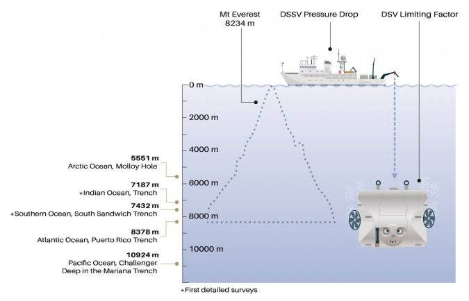
As part of the Five Deeps Expedition (FDE) team, scientists from Caladan Oceanic LLC and the British Geological Survey (BGS) have surveyed in detail the deepest reaches of the Java and South Sandwich trenches. Data published in Geoscience Data Journal shows the deepest point of the Indian Ocean at 7,187m, within the Java Trench, and the deepest point of the Southern Ocean at 7,432m, within the South Sandwich Trench.
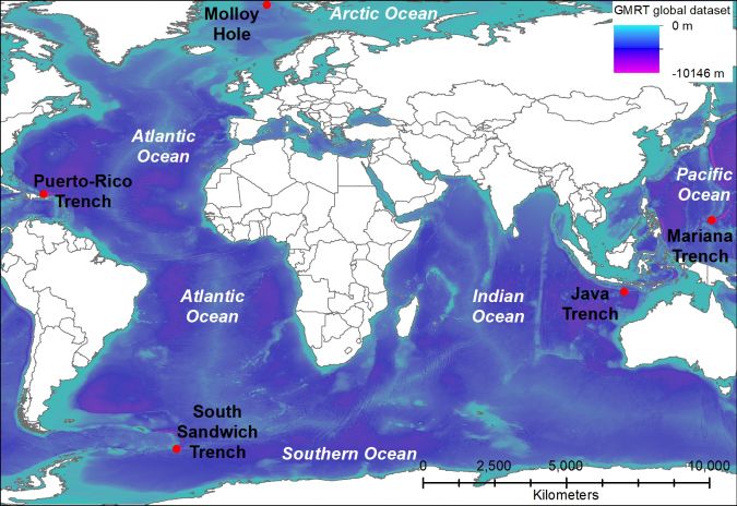
Prior to the FDE, the deepest parts of some oceans were relatively well known, such as Challenger Deep in the Mariana Trench, but others had multiple ‘deeps’ where several contenders challenged for the deepest point in that particular ocean.
Until now, there had been a lack of high-resolution data available for the Indian Ocean and Southern Ocean and there was considerable doubt as to the exact location of the deepest point, let alone accurate depth measurements.
Multibeam Sonar Survey of Deep-sea Trenches
Located just north of the Antarctic continent, the South Sandwich Trench spans both the Southern and Atlantic oceans. It had not been thoroughly explored prior to the FDE mission and is the only sub-zero hadal zone (deeper than 6,000m) in the world. The FDE survey produced the most accurate mapping of the South Sandwich Trench to date, using a modern multibeam sonar system. The new survey has shown that the deepest point of the trench is Meteor Deep at 8,265 m and that it is located within the waters of the Atlantic Ocean. The recently named Factorian Deep, located at the southern end of the trench, is 7,432m deep.
The Java Trench, in the eastern Indian Ocean, is more than 4,000km long. In April 2019, the FDE undertook the first crewed descent to the absolute bottom of the trench (7,187m). This mission also produced the deepest dive by a British citizen, Prof. Alan Jamieson, who was also the first British person to descend into the hadal zone. Since then, Prof. Jamieson and fellow Brit John Ramsay have also dived to the deepest points of the Mariana Trench, beating that record, during the FDE.
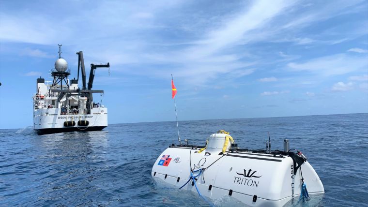
Full-ocean Depth Crewed Submersible
The submersible DSV Limiting Factor – known as one of the most uniquely capable piloted vehicles in seafaring history – played a crucial role in mapping the deeps. The DSV Limiting Factor and the three supporting free-fall lander systems were fitted with specialist sensors that recorded data during both their descent to the sea floor and their return journey to the ship. These data were used to calculate full-ocean depth sound velocity profiles to correct the multibeam bathymetry data. Many offshore expeditions do not have the time or technology to send these sensors to the sea floor, so rely on sound velocity models rather than direct measurements, making this work unique.
The area mapped for the first time during the FDE is roughly equivalent to the size of Finland.
“The global Five Deeps Expedition allowed us a unique opportunity to accurately map some of the most remote and deepest places in the world, and to validate these depths with measurements collected by the submersible and support landers,” said Cassandra Bongiovanni, chief hydrographic surveyor for the FDE and lead author of the study. “Access to state-of-the-art full-ocean depth technology allowed us to map an area equivalent to continental France in only 10 months. Around 61% of where we went had never been mapped using modern technology,” she added.
“Initiatives such as the Five Deeps allow us to fill in knowledge gaps and reveal for the first time the seascape of large underwater features like subduction trenches. Collecting detailed bathymetry data allows us to further understand past and current processes, and to explore links between geology and the biodiversity of these ultra-deep environments,” commented Heather Stewart, BGS marine geologist.


