FarSounder Joins NOAA as a Trusted Node
FarSounder is the most recent company to join the International Hydrographic Organization’s Crowd-Sourced Bathymetry (CSB) initiative by becoming a “trusted node” with the NOAA. This project enables mariners to voluntarily contribute seafloor depths measured from their vessels to NOAA’s data repository. The partnership can be seen as a logical step because FarSounder’s customers regularly travel to remote areas with poorly maintained nautical charts, using a FarSounder 3D-FLS for real-time navigation.
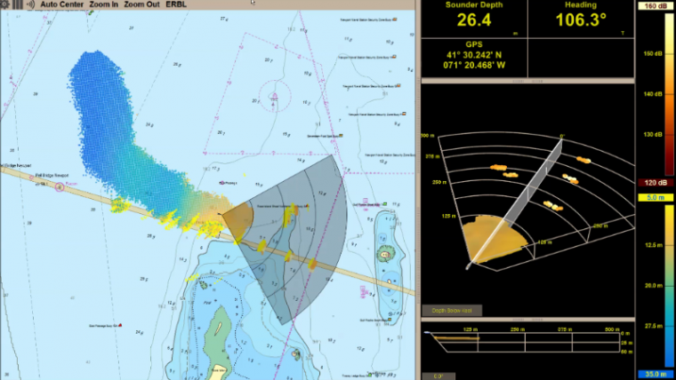
Due to the development of FarSounder’s Local History Mapping (LHM), the latest feature of its SonaSoft software, users now have the ability to create a real-time chart of the seafloor which they recently sailed and collect this bathymetric data.
Bathymetric data to fill the gaps in seafloor mapping
Collecting these LHM datasets and contributing them to the IHO Data Centre for Digital Bathymetry (DCDB) hosted by NOAA’s National Centers for Environmental Information will allow the worldwide use of this data. This can be used for a variety of purposes including the assessment and production of nautical charts in all waters. This collaboration between FarSounder, the IHO, and NOAA will aid in making the world’s waterways a safer place to navigate.
“To truly fill the gaps in seafloor mapping, we need bathymetric data contributions from everyone, not just traditional survey vessels,” said Jennifer Jencks, director of the IHO DCDB. “As the recognised archive for global bathymetry, we’re excited to be a part of this international effort by continuing to provide access to the world’s largest collection of digital bathymetry.”
FarSounder has recently begun a pilot project that will allow select customers to submit their standard single-beam echosounder (SBES) depth measurements, recorded along with other navigational information through FarSounder’s SonaSoft software, to the IHO DCDB database. If the vessel operators agree to contribute their location and depth measurements, hydrographic offices (HO), will have access to these datasets when updating and maintaining charts in these areas. One major benefit of vessel operator’s CSB contributions is the HO’s improved ability to provide an accurate diagram for all mariners to follow.
Many areas’ charts left outdated
Often, HO survey operations prioritise heavily trafficked areas, meaning that many areas’ charts are left outdated. However, mariners still explore these areas, often with a variety of sensors for their own safety, including standard SBES and/or 3D-FLS. Bathymetric data collected by these everyday mariners using these sensors, if provided to the DCDB, will help HO’s inform their chart production and survey operations in order to keep their trips safer.
FarSounder is committed to this IHO initiative and will continue to work closely with NOAA as a “trusted node”. FarSounder’s LHM software feature introduces the potential for bathymetric data to be collected and shared with the IHO DCDB and the public in the future. With the help of FarSounder’s 3D-FLS and the SonaSoft software with the LHM feature, efficient navigation and exploration is far more achievable.
Data contributed to the DCDB will be automatically archived and made freely available through the IHO DCDB Data Viewer for commercial, scientific, or personal use.


