Full Seazone UK Coastal Coverage
SeaZone can provide full UK coastal coverage of TruDepth Grids. SeaZone TruDepth Grids is a solution which delivers the best available information on water depth around the UK. The latest areas to be produced are along the east coast from the Scottish Borders to The Wash, The Isle of Man and offshore Cornwall.
SeaZone TruDepth Grids is used by many organisations including: Government, energy companies, universities, research institutions, and consultants. It is used for marine spatial planning, site selection activities, habitat map creation, volumetric calculations, nutrient loading models, capacity planning and general bathymetry background mapping. The data can be used in most GIS and modelling software. Users of SeaZone TruDepth Grids report many benefits such as; data procurement cost savings, time savings, reduced project risk, better support for decision making and more accurate modelling.
SeaZone TruDepth Grids are created from a Digital Terrain Model (DTM) based on the best available surveys (for example best sounding density and most up to date surveys) that are held in our bathymetry database. The SeaZone database includes around 20,000 survey blocks, 500 of which have been scanned, geo-referenced and digitised from UKHO archive fairsheets. Charted bathymetric data is acceptable for background mapping and coarse scale generic assessment, but for accurate design, engineering and numerical modelling, it is not advisable to use charted data.
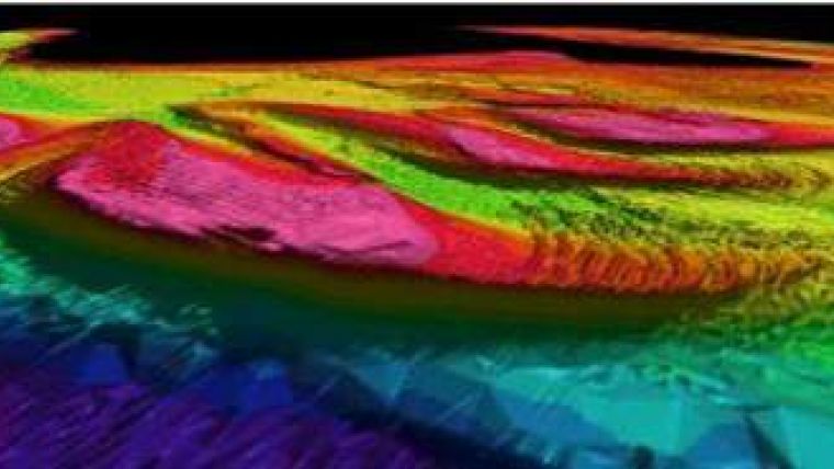
At a resolution of 1 arc second (or approximately 25m, depending on latitude), physical features such as trenches, ridges, sand banks and sand waves are significantly more distinguishable with SeaZone TruDepth Grids. SeaZone TruDepth Grids are available in half degree (~100km) tiles in ASCII Grid and ESRI Binary Grid formats. They are referenced to Chart Datum but can be transformed to other vertical references by SeaZone.


