Iceberg Monitoring
A joint experiment between SUE Atomflot and ScanEx Research & Development Centre, Russia, was conducted in September 2011 on the overall detection of icebergs in the Vilkitsky Strait, which is the narrowest and most congested section of the Northern Sea Route between the Taimyr Peninsula and Severnaya Zemlya.
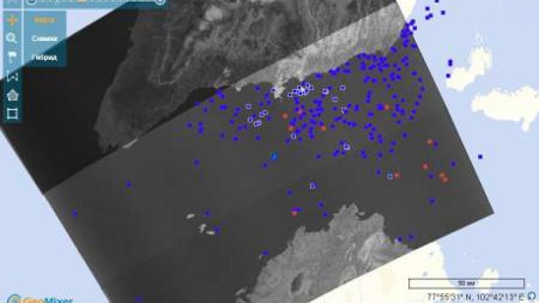
At the preliminary stage of the experiment the Atomflot Staff of Ice Operations reported the coordinates of icebergs, visually detected from board the icebreakers and using on-board radar. Equipped with this information ScanEx RDC conducted overall real-time imaging of the Strait area using radar and optical satellites data.
Information about the icebergs location, received as a result of satellite images processing, was submitted to the Ice Operations Staff of Atomflot for further transmission to ships passing the Strait. Regular satellite imagery of the Vilkitsky Strait was carried out further to detect icebergs. According to satellite-based monitoring data, the largest icebergs were over 120-200m in length. Joint ship-based and satellite-based surveys helped to detect a large stranded iceberg 7.5km away from the coast of the Taimyr Peninsula.
During this experiment images from RADARSAT-2 satellite, received in new extended imaging mode that enables to enlarge the swath width threefold, were synthesized. It is detected that a 170-km swath of 2-3 scenes in Wide Fine mode is enough to control of the entire Vilkitsky Strait. Fine imaging mode of 50km wide applied earlier did not ensure single-pass coverage of the entire strait.
It should be noted that the islands of the Severnaya Zemlya archipelago were opened 98 years ago by the hydrographic expedition of the senior lieutenant of the Russian Fleet Boris Vilkitsky consisting of two icebreaking ships Taimyr and Vaigach. On 4th September 1913 the expedition crew lifted the Russian flag on this terra nova, which became one of the greatest geographic discoveries of the 20th century. The first sign of approach to an unknown land was the appearance of huge icebergs of 15m high that never happened before. Icebergs in this Arctic area form on the glaciers of the Severnaya Zemlya, which cover over 40% of the archipelago surface.
Fine-tuning of near real-time satellite-based iceberg monitoring technology will enable to increase navigation and production safety on the continental shelf of the Arctic Region.


