Live Streaming Video from the Ocean Floor
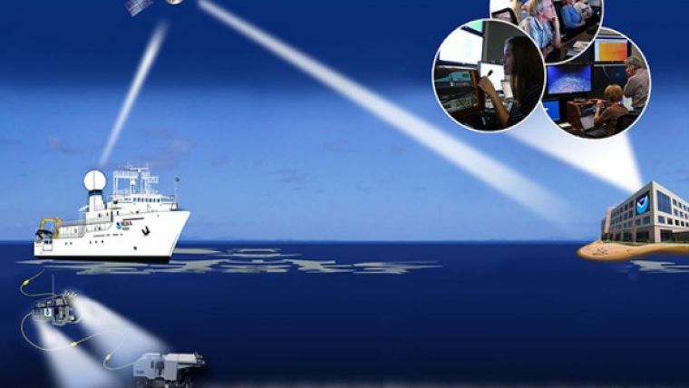
From 10 July to 30 September 2015, NOAA ship Okeanos Explorer is exploring largely unknown deep-sea ecosystems in the Hawaiian Archipelago and offshore Johnston Atoll as part of the Hohonu Moana: Exploring the Deep Waters off Hawai’i expedition. Telepresence technology is being used to transmit data in real time to a shore-based hub where the video is then transmitted to a number of Exploration Command Centres located in the USA and the cloud. Access to the video and a suite of internet-based collaboration tools enable scientists on shore to join the operation in real time and allow the general public to follow the expedition online.
During four separate cruise legs, NOAA and partners will investigate deep waters in and around Papahānaumokuākea Marine National Monument (PMNM) in the Northwestern Hawaiian Islands, Johnston Atoll in the Pacific Remote Islands Marine National Monument (PRIMNM), the Geologists Seamounts group, and the Main Hawaiian Islands.
Operations
The expedition marks the third field season using NOAA’s 6,000-metre remotely operated vehicle Deep Discoverer and the Seirios camera sled and lighting platform on NOAA Ship Okeanos Explorer. A pilot sampling programme is being conducted during the July to September Hohonu Moana Expedition to collect geological and biological samples that are deemed to be of particular interest to the expedition’s NOAA and academic partners.
Priority operating areas and science themes for this 69-day expedition were developed with input from scientists and managers across the broad ocean science community. Themes and objectives for the 2015 Expedition include:
- Acquire data to support priority marine national monument and national marine sanctuary science and management needs;
- Identification and characterization of vulnerable marine habitats - particularly high-density deep-sea coral and sponge communities;
- Characterization of seamounts within the Prime Crust Zone (PCZ), an area of the Pacific with the highest expected concentration of deep-sea minerals, including rare metals and rare earth elements;
- Collect information on the complex geologic history of Central Pacific Seamounts, particularly those that are or may be relevant to our understanding of plate tectonics; and
- Provide a foundation of publicly accessible data and information products to spur further exploration, research, and management activities.
Operations will use the ship’s deep-water mapping systems (Kongsberg EM302 multibeam echo sounder, EK60 split-beam fisheries sonar, and Knudsen 3260 chirp sub-bottom profiler sonar), NOAA’s two-body 6,000-metre remotely operated vehicle (ROV) system, CTD rosette, and a high-bandwidth satellite connection for real-time ship to shore communications.
ROV dives will include high-resolution visual surveys and limited sampling – including the first-ever look at deep seafloor habitats offshore of Johnston Atoll below 400 meters and habitats deeper than 2,000 metres in PMNM.
Four Legs
The 69-day expedition is divided into four ‘legs’ – one 24-hours-a-day mapping leg followed by three combined ROV/CTD/mapping legs. The tentative schedule for the full expedition is:
Leg 1 (10-24 July): Mapping exploration cruise focused offshore of Johnston Atoll
Leg 2 (31 July to 22 August): Telepresence-enabled ROV/CTD/mapping cruise focused on PMNM.
Leg 3 (28 August to 3 September): Telepresence-enabled ROV/CTD/mapping cruise focused offshore the Main Hawaiian Islands and Geologists Seamounts.
Leg 4 (7-30 September): Telepresence-enabled ROV cruise focused offshore of Johnston Atoll.
Telepresence-enabled Exploration
The United States’ first and only federal vessel dedicated to exploration of our largely unknown ocean, NOAA Ship Okeanos Explorer conducts operations in a globally unique way, using telepresence to engage the majority of the science team from shore.
Via telepresence, live images from the seafloor and other science data will flow over satellite and high-speed Internet pathways to scientists around the country standing watches in Exploration Command Centers (ECCs), tuning in to the high-definition video using their institution’s Internet 2 connection, or watching the live video on commodity Internet. They will join an expedition teleconference and log into a centralized instant messaging server to contribute expertise and help guide the at-sea operation in real time, extending the reach of ocean exploration to more scientists and students than could ever be accommodated onboard.
A number of ECCs will be online for the expedition, including several ECCs joining Okeanos Explorer operations for the first time. ECCs online include: the University of Hawaii at Manoa; NOAA's Inuoye Regional Center in Hawaii; NOAA Headquarters in Maryland; Harbor Branch Oceanographic Institution in Florida; Inner Space Center at the University of Rhode Island; Stennis Space Center in Mississippi; University of New Hampshire; and Pacific Marine Environmental Laboratory in Washington.
The live feed is accessible online.


