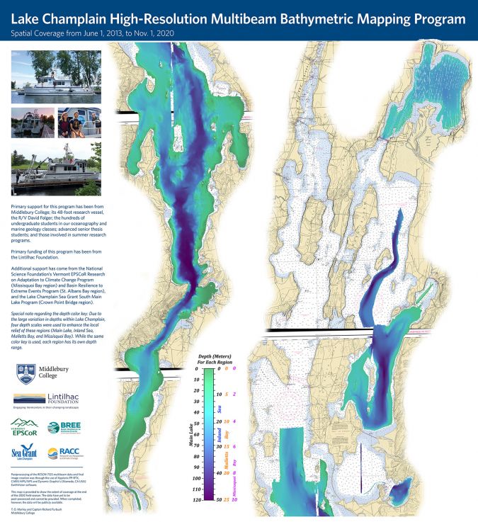
Mapping the Depth of Lake Champlain
A researcher and crew at Middlebury College in Vermont are using bathymetric technologies to develop a map of the depths of Lake Champlain. Between 2012 and 2020, Professor Tom Manley and Captains Richard Furbush and Tom Beardsley used multibeam technology to measure the depth of Lake Champlain in four different regions: Main Lake, Inland Sea, Mallets Bay and Missisquoi Bay. This was done on board the college’s research vessel the David Folger. Although the measurements are not yet fully complete, Manley has posted a bathymetric map on the Lake Champlain Basin Program website.
The map shows the depth detail of the lake, from 1 June 2013 to 1 November 2020. Due to the large variation in depths in Lake Champlain, four separate depth scales were used on the map to enhance the local relief of each of the four regions.
Lake Champlain’s greatest depth is about 120m, just north of the Thompson’s Point/Split Rock area in the Main Lake, while the Inland Sea region is up to 50m deep. Mallets Bay is less than 32m deep, while Missisquoi Bay is consistently less than 4m deep.
512 Underwater Receivers
The multibeam system used by Manley on the RV David Folger works like an advanced fish finder and is equivalent to 512 fish finders operating simultaneously. Newer multibeam systems have up to 2,048 individual beams.
Although the system is very complex, the concept is simple in that a sound pulse goes out to the lake bottom from the instrument’s sonar projector mounted on the side of the boat. The reflected sound pulse is then recorded by an array of 512 underwater receivers (each aligned at a different angle) on the boat. Half of the receivers are listening for returns at various distances away from the vessel’s port side, while the other 256 receivers are doing the same on the starboard side.