MH370 Search Discovers Shipwreck
Fugro Equator’s deep tow system detected a cluster of small sonar contacts in the southern part of the search area for missing flight MH370, 12 nautical miles to the east of the 7th arc. The sonar data was carefully analysed and categorised as Class 2: ‘of potential interest but unlikely to be related to MH370’. Analysis of the images revealed that the debris was indeed man-made, but indicated that it was actually the wreck of a ship. This wreck is previously uncharted and the imagery will be provided to expert marine archaeologists for possible identification.
Australian Transport Safety Bureau (ATSB)’s Peter Foley, director of the Operational Search for MH370, said there were aspects that generated interest, multiple small bright reflections in a relatively small area of otherwise featureless seabed. All the sonar data the ATSB gathers goes through a detailed analysis and an exhaustive review process to ascertain its quality, coverage and most importantly any sonar contacts of interest. The analysis starts with the mission crew on board the search vessels, data is then reviewed again ashore by sonar analysts at Fugro’s office in Perth and then it is independently reviewed by the sonar experts in the ATSB’s Operational Search team. The process is methodical, meticulous and it is designed to ensure that nothing is missed. In this case a resurvey of the contact in more detail was planned when the opportunity arose.
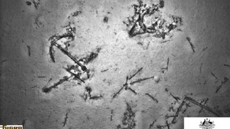
Therefore Fugro Supporter was tasked to divert on its passage between two search areas and further investigate the contact. A high-resolution sonar scan was performed using the AUV. The high-resolution data revealed a large number of sonar contacts lying very close to the seafloor, at a depth of around 3,900 metres. The majority of the contacts were comparatively small – around the size of a cricket ball – interspersed with a few larger items, the biggest being box shaped and approximately 6 metres in its longest dimension. The debris field appeared to be of man-made origin but once again it did not exhibit all the characteristics of a typical aircraft debris field.
An additional AUV low-altitude mission was then undertaken using the underwater camera to gather images of the field. Poor weather conditions, however, prevented the safe launching of the AUV for several days.
Since this shipwreck was not what the researchers were looking for, the search for MH370 will continue and the vessels have already moved to pursue the mission. According to Mr Foley, this event has demonstrated that the systems, people and the equipment involved in the search are working well. It has shown that if there is a debris field in the search area, it will be located.
Image: Ship-related debris on the sea floor, including an anchor. Image courtesy: Fugro.


