Multi-agency Expedition to Atlantic Canyons
The US Bureau of Ocean Energy Management, Regulation and Enforcement (BOEMRE), the National Oceanic and Atmospheric Administration (NOAA) and the US Geological Survey (USGS) are joining forces for an ocean research project. Scientists will map deepwater canyons 100 miles off the Maryland coast using sonar and identify sensitive biological habitats, coral communities and archaeological sites such as shipwrecks and other historically significant sites.
This cooperative effort to gather information for science-based decision making is consistent with the National Policy for the Stewardship of the Oceans, Our Coasts and Great Lakes, adopted by President Obama in July 2010.
The survey crew is using sonar aboard the ship to generate 3D bathymetric seafloor maps. These maps will allow scientists to identify features on the seafloor to be investigated over the next two years during follow-on expeditions.
The team sailed on 4th June from Charleston, S.C., aboard NOAA Ship Nancy Foster to an area about 100 miles off the coast of Virginia and Maryland where the canyons are located. The expedition ends on 17th June, and is the first of several in a joint-agency partnership over the next three years. Total funding for the three-year study is approximately USD9 million, shared equally among the three agencies.
The expedition is conducted through an interagency agreement as part of the National Oceanographic Partnership Program (NOPP). NOPP involves BOEMRE, NOAA and USGS and maximises the use of federal resources, such as human capital, ships and equipment at reduced costs, while meeting national priorities and advancing specific scientific missions of the agencies in partnership.
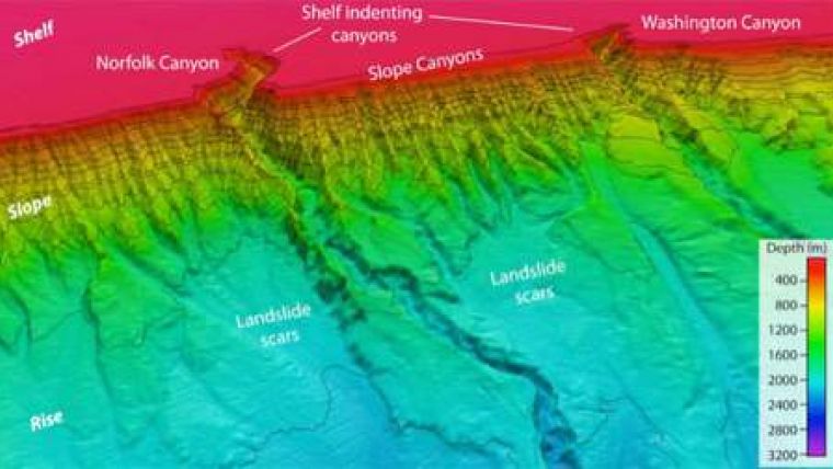
Image: Deep submarine canyons are perhaps the most striking feature of the continental margin of the eastern United States. Most of these canyons are relatively minor features, but several are incredibly extensive and cut quite deeply into the seafloor. This image shows the Norfolk and Washington Canyons along the continental margin offshore of Virginia. Image courtesy of USGS.


