Multibeam Sonar Reveals Underwater Volcano Near Christmas Island
An ancient undersea volcano has been revealed by multibeam sonar, 280 kilometres southeast of Christmas Island and 3,100 metres below the sea surface. The discovery by CSIRO’s dedicated ocean research vessel, the RV Investigator, is part of its mission to map the seafloor and survey sea life in these ancient and secluded seascapes.
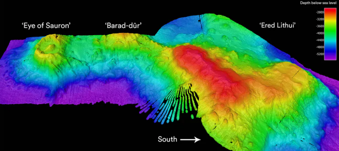
Looking like the Eye of Sauron from the Lord of the Rings, the ancient volcano was slowly revealed on day 12 of the voyage of exploration to Australia’s Indian Ocean Territories aboard the RV Investigator.
Volcanic Eyes
Previously unknown and unimagined, this volcano emerged from the onboard screens as a giant oval-shaped depression called a caldera, 6.2km by 4.8km across. It is surrounded by a 300m-high rim (resembling Sauron’s eyelids), and has a 300m-high cone-shaped peak at its centre (the ‘pupil’).
A caldera is formed when a volcano collapses. The molten magma at the base of the volcano shifts upwards, leaving empty chambers. The thin solid crust on the surface of the dome then collapses, creating a large crater-like structure. Often, a small new peak then begins to form in the centre as the volcano continues spewing magma.
One well-known caldera is the one at Krakatoa in Indonesia, which exploded in 1883, killing tens of thousands of people and leaving only bits of the mountain rim visible above the waves. By 1927, a small volcano, Anak Krakatoa (child of Krakatoa), had grown in its centre.
In contrast, we may not even be aware of volcanic eruptions when they happen deep under the ocean. One of the few tell-tale signs is the presence of rafts of light pumice stone floating on the sea surface after being blown out of a submarine volcano. Eventually, this pumice stone becomes waterlogged and sinks to the ocean floor.
The volcanic ‘eye’ was not alone. Further mapping to the south revealed a smaller sea mountain covered in numerous volcanic cones, and further still to the south was a larger, flat-topped seamount. Following the Lord of the Rings theme, they were nicknamed Barad-dûr (Dark Fortress) and Ered Lithui (Ash Mountains), respectively.