Multibeam Sonar to Detect and Map Deep-sea Gaseous Seeps
Multibeam sonar, an echo sounding technology commonly used to map the seafloor, can also be used to map and detect gaseous seeps in the water column, according to scientists testing the technology onboard NOAA Ship Okeanos Explorer last week in the Gulf of Mexico. Unlike other types of sonar, multibeam technology is able to survey a wide area of the seafloor and water column.
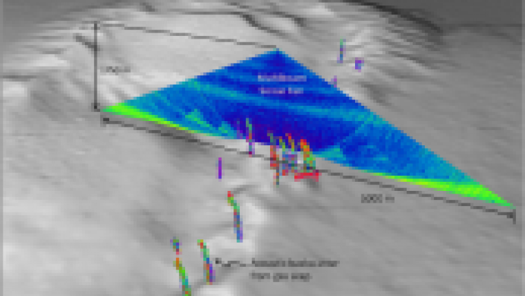
The ship's multibeam system produced data to make high-resolution maps of gas in the water column in depths ranging from 3,000 to 7,000 feet (1,000 to 2,500 metres).
"This capability will help increase our knowledge of the marine environment, including the distribution of natural sources of methane input into the ocean and the identification of communities of life that are often associated with methane gas seeps," said Thomas Weber, Ph.D., of the University of New Hampshire's Center for Coastal and Ocean Mapping and lead scientist of the mission.
The expedition was conducted jointly by NOAA's Office of Ocean Exploration and Research (OER), the University of New Hampshire's Center for Coastal and Ocean Mapping, and the Bureau of Ocean Energy Management, Regulation and Enforcement (BOEMRE), as well as scientists and technicians from NOAA's Southeast Fisheries Science Center working in parallel from NOAA Ship Pisces.
"In 2009, we were testing Okeanos Explorer's multibeam sonar off the U.S. West Coast when the sonar first displayed its potential to acoustically map the water column," said Mashkoor Malik, a physical scientist with NOAA's OER and expedition coordinator for the mission. "The sonar mapped a plume of suspected methane gas that rose 4,200 feet (1,400 meters) from the seafloor. But this expedition in the Gulf was the first comprehensive test of Okeanos Explorer's multibeam to detect deep gaseous seeps over a wide area. Its use during this mission confirms the effectiveness of the tool and may lead to extending NOAA's water-column mapping capabilities."
Bill Shedd, a BOEMRE geophysicist and expert in hydrocarbon seeps who participated in the expedition as part of an ongoing collaboration with NOAA's OER, stated, "Our agencies have been working together in the Gulf of Mexico since 2003. We're optimistic and impressed about this new capability for exploration that was demonstrated so well during this expedition."
NOAA Ship Okeanos Explorer is operated, managed and maintained by NOAA's Office of Marine and Aviation Operations, which includes commissioned officers of the NOAA Corps and civilian wage mariners. NOAA's OER owns and is responsible for operating and managing the cutting-edge ocean exploration systems on the vessel. It is the only federal ship dedicated to systematic exploration of the planet's largely unknown ocean.
Observing 10 years of ocean exploration, NOAA OER uses state-of-the-art technology to explore Earth's largely unknown ocean in all its dimensions for the purpose of discovery and the advancement of knowledge. Expeditions are chronicled at oceanexplorer.noaa.gov, with images and logs from sea.


