Natural Oil Detected in Black Sea
The Black Sea oil pollution monitoring programme has revealed natural oil sources in the south-eastern part, offshore Poti, Georgia. The source was detected based on analysis of multi-temporal radar satellite images by scientists of the Shirshov Institute of Oceanology working with specialists at the ScanEx Research & Development Center.
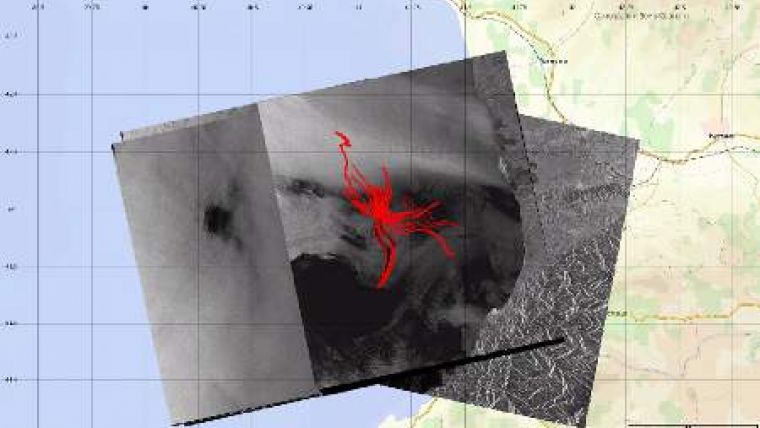
Analysis of radar images enabled to detect the connection between the oil seeps, visible on the sea surface and the process of formation and migration of hydrocarbons in sedimentary complex of the south-eastern part of the Black Sea. Based on the analysis of spots, detected on sixteen multi-temporal radar images, acquired over from 1993 to 2011, the GeoMixer web-mapping application helped defining the location of the source on the sea bottom. The coordinates of the source are 41 58'59''N and 41 07'30''E at the depth of 1,050 metres and it erupts once in 0.3-5 hours. First reliable monitoring of this spring from space using radar was made in December 1993.
Senior researcher of the Shirshov Institute of Oceanology Andrei Ivanov explains: "Such a natural infiltration of oil is one of the typical phenomena in this part of the Black Sea. Oil seepage volumes assessments can be made by measuring the acreage of oil slicks on radar images and based on simple physical considerations, connecting the thickness of oil slick with its colour that varies from iridescent on the place of emergence to silver-grey on the spot edges".
According to estimates of the institute specialists the oil-in-place relief in south-eastern part of the Black Sea only from this source (if recurrent discharge trend remains) may constitute on average from 1 to 8 tons of oil per day or 400 to 3,000 tons per year. The maximum possible estimates of volumes of natural oils seepage in this place according to space radar data may reach 7,000 tons of oil per year.
Detailed biometric data showed that the bottom in this location has a positive topographic form - the mountain of Pechori that, apparently, is the source of these oil blowouts. Data of independent geophysical studies, carried out by IFM-GEOMAR (Kiel, Germany) together with Russian specialists, confirm that too. In addition, radar images of this area detected a number of smaller oil slicks associated with secondary level phenomena that indicate the presence of a number of other natural oil sources. They are also of some interest and require further investigation.
The use of multi-temporal radar images enables to considerably increase the probability of natural oil sources detection at seas. For analysis and research of natural oil seeps, detected using radar images, the method developed at the Institute of Oceanology was applied. In particular, the geoinformation approach was used. Such an approach was also used to study and event to detect natural oil sources in the Caspian Sea, on the north-eastern shelf of the Sakhalin Island and in Lake Baikal.
"Radar images can be applied for operational monitoring of different objects on the sea bottom, periodically emitting oil or oil derivatives, for example damaged or broken oil pipelines, sunken ships, mothballed wells," notes ScanEx Deputy General Director Alexei Kucheiko.


