Olympic Coast Survey Acquires Data for Multiple Uses
Coastal planners, fishery managers and oceanographic researchers will soon reap seafloor and water-column data from the coast of Washington, USA, as NOAA ship Rainier undertakes a project in the waters within and near the Olympic Coast National Marine Sanctuary this month.
The project, which is being managed by NOAA’s Integrated Ocean and Coast Mapping programme, grew from NOAA’s National Centres for Coastal Ocean Science seafloor mapping prioritisation exercise among coastal stakeholders from federal and state (Oregon and Washington) agencies, tribes and academia. The group determined that one of the biggest needs by most of the organisations was a better understanding of canyon depths, seafloor and habitat.
Survey Once, Use Often
A scientific team of experts from the College of Charleston, University of Washington, and Oregon State University will contribute to the NOAA-led multi-disciplinary survey project, gathering data for a host of research projects and ocean management activities. In general, the data will collect swath bathymetry, acoustic backscatter and water column data aiming to:
- inform regulatory decisions on coastal development;
- provide benthic habitat mapping and seafloor characterisation for sustainable fisheries initiatives, and to help assess fishery stocks and critical spawning aggregation locations;
- better understand and manage shelf and canyon resources;
- aid in resolving multiple-use conflicts;
- advance research in determining chemical and biological contamination levels; and
- provide a data repository for the development of ocean tourism and recreational fishing.
Some specific research projects are also planned.
Gas Plumes Analysis
A University of Washington scientist will analyse the water column plumes over natural methane gas seeps in the planned survey areas. The university is a leader in the study of methane hydrates.
Because Rainier heads to Alaska after the survey in the sanctuary, the ship will also conduct an exploratory survey to obtain seafloor imagery and data over a newly discovered mud volcano in the upper continental slope offshore of Dixon Entrance, just off the Inside Passage near Ketchikan, Alaska. California State researchers will use the data from this 40 square nautical mile survey to analyse the seafloor shape, assess the area for effects on potential tsunamis, and identify unique biological communities.
Regular Chart Update Survey
As part of her regular mission, Rainier will acquire depth measurements and other hydrographic data throughout the entire project to update NOAA nautical charts 18480 and 18500 off the coast of Washington, and chart 17400 in Alaskan waters. The corresponding electronic navigational charts (NOAA ENC®) are US3WA03M, US3AK40M, and US3AK40M.
Chris Stubbs, from the College of Charleston, will serve as the project’s chief scientist. Cmdr. Edward J. Van Den Ameele is Rainier’s commanding officer.
NOAA ship Rainier, a 48-year-old survey vessel, is part of the NOAA fleet of ships operated, managed and maintained by NOAA’s Office of Marine and Aviation Operations, which includes commissioned officers of the NOAA Corps, one of the seven uniformed services of the United States, and civilian wage mariners.
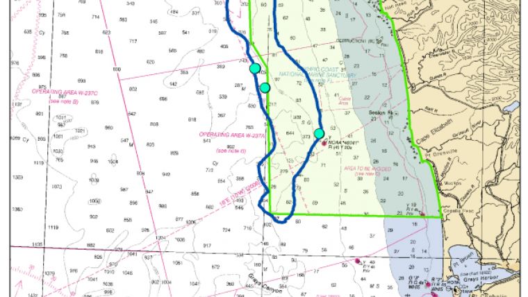
Image: The blue lines indicate NOAA Ship Rainier’s survey project areas. From north to south, the project encompasses Juan De Fuca Canyon (65 square nautical miles), Quinault Canyon (378 square nautical miles), and Willapa Canyon (189 square nautical miles). The teal dots in Quinault and Willapa canyons are the locations of deep underwater natural methane gas seeps being investigated in a University of Washington research project. The green shaded area is the extent of the Olympic Coast National Marine Sanctuary.


