OSRL Tests and Validates Remote Sensing Equipment
A recent offshore exercise, conducted by Oil Spill Response Ltd. (OSRL, UK), was designed to understand how remote sensing technologies can help detect oil spills at sea more effectively. Utilising the latest in satellite, airborne and in-water surveillance and communications equipment, the successful event demonstrated the value of the technology in identifying and monitoring spills and was conducted with full approval of the Marine Management Organisation (MMO) following a rigorous planning and stakeholder consultation process.
The main surveillance tools and providers involved in the exercise included:
- Radar and optical satellite imagery (MDA, Earth-I, Airbus, Telespazio)
- Infra-red and Ultraviolet sensors on the OSRL UKCS aircraft (2Excel Aviation)
- Airborne hyperspectral sensors (2Excel Aviation)
- Unmanned Aerial Vehicles (UAVs) (Sky Futures and Bristow Group)
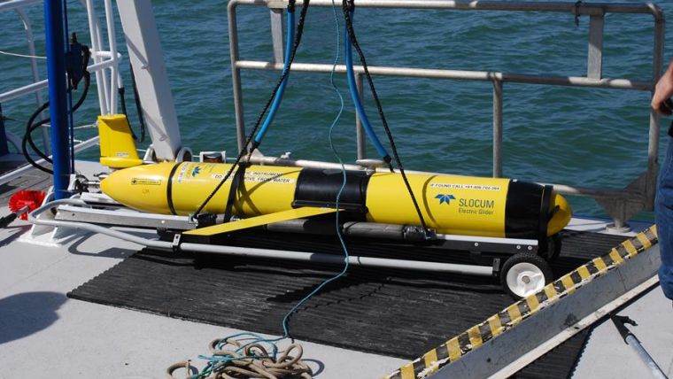
- Autonomous Underwater Vehicles (AUVs) (Blue Ocean Monitoring and Planet Ocean)
- A surveillance kite with COFDM link (Domo Tactical Communications (DTC))
- IP Mesh Network on vessel and crew (Briggs Marine and DTC)
The exercise was showcased through OSRL’s Southampton-based Visualisation Centre, which provided a ‘Common Operating Picture’, integrating data from each of the technology partner’s equipment as well as oil spill modelling platforms and satellite feeds.
The exercise took place on 13 June 2017 in open sea off the southern coast of England. A minimal amount of oil was released under carefully controlled conditions and with approval from the MMO. On hand was the full complement of oil spill response equipment and personnel, including a purpose-equipped vessel, containment and recovery equipment and UK approved dispersant.
According to Robert Limb, chief executive for Oil Spill Response Ltd, achieving maximum effectiveness in response to an oil spill incident is based on prior preparedness and understanding the capabilities of the equipment contained within the company’s ‘response toolkit’. As a result, they are constantly reviewing the potential impact the latest response technology can have on further negating the impact of a spill incident. Through the course of this exercise they were able to monitor, evaluate and mitigate the oil – giving the company, members and the general public confidence in OSRL's systems and approach.
The remote sensing technology used was able to identify and monitor the controlled spill, and OSRL was satisfied by the performance of the various new technologies involved. In addition, the response equipment and personnel operated in a efficient and effective manner providing validation of OSRL’s approach.
OSRL work closely with technical partners to monitor developments in cutting-edge remote sensing technology to identify development opportunities.


