Pelydryn Buys CHIROPTERA II for Shallow Water Survey
Pelydryn, UK, has bought the CHIROPTERA II topo-bathy Lidar system from Airborne Hydrography and Leica Geosystems. Introduced in early March 2014, CHIROPTERA II is a Lidar system which simultaneously captures the full waveform in both the 35kHz bathymetric channel and the 500kHz topographic channel.
The system targets the growing need for high-resolution accurate topographic and bathymetric surveys in the coastal zone and other shallow water regions, achieving depths of up to 15 metres. In the Chiroptera system, the Lidar data from land is recorded and stored separately from the bathymetry data. The Chiroptera uses two Lidars, one red laser for topography and one green for bathymetry. During surveying and data acquisition, both channels are recorded simultaneously. With a full topographic capability, this makes the CHIROPTERA II suited for near-shore and land surveying. The system integrates the Leica RCD30 80MP camera allowing high-resolution surface imagery to be captured simultaneously during airborne surveys.
The CHIROPTERA II sensor is joining Pelydryn’s current HawkEye II bathymetric Lidar capability with improved data quality in the shallow water segment.
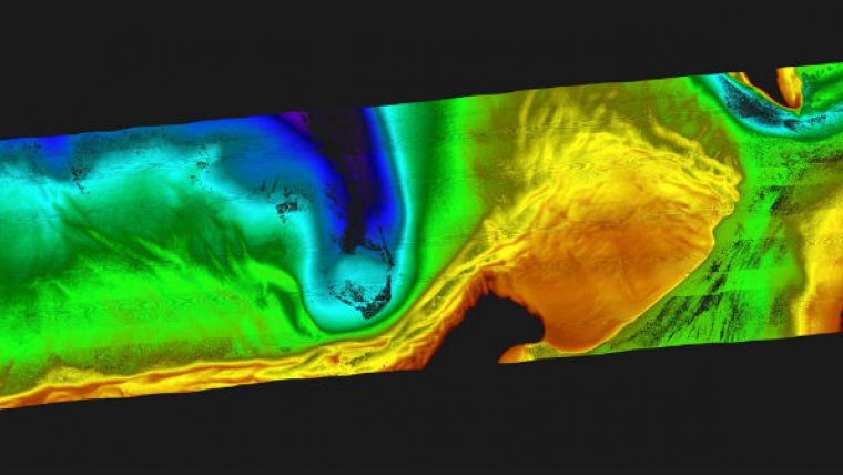
Image: The bathymetry image in the press release is a colour-coded image of the seafloor topography. The deepest area is around 10m. The image shows one flight line from a survey using the Chiroptera II. The black, within the blue deep region, is an area that is too deep for the LiDAR to reach i.e. deeper than approx 10m. The black area in the red area is above sea level i.e. land. The land data is filtered out as the data shown is only the bathymetry data, and does not include topographical information. Image courtesy: Leica Geosystems.


