Physical Oceanography and Sea-ice Physics
The annual Fram Strait cruise in September 2008 with R/V Lance is a long standing tradition at Norwegian Polar Institute. Since 1997 NPI has been deploying 4 to 6 moorings (containing around 20-24 instruments in total) in the East Greenland Current to measure temperature, salinity and velocities at different depths in the Fram Strait.
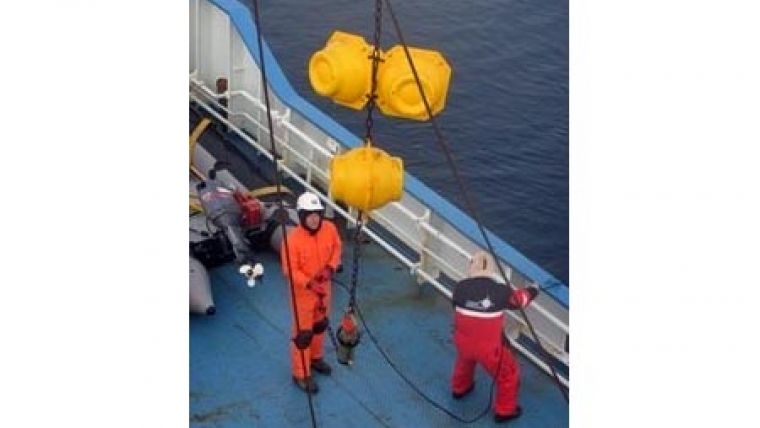
The purpose is to analyse the outflow of water masses and sea ice from the Arctic into the Nordic Seas and Atlantic Ocean. Due to anomalously heavy sea-ice conditions in 2007 we were not able to recover any of the 6 moorings last year. Hence, this year's priority was to get those moorings back before the winter starts and hopefully redeploy them with new instruments.
Leaving Longyearbyen on Saturday August 30 we steamed straight to the 1st mooring location at 78º50'N, 3ºW since both the weather forecast and sea-ice maps looked very promising. Tight planning, hard work and very fortunate sea-ice conditions made it possible for us to recover all 6 Fram Strait moorings in 3 days. Not bad. To our surprise most of the instruments were still logging and had not run out of battery or memory even though it wasn't planned to have them out in the ocean for 2 years in a row. This means that we have a complete 2-year time series to add to the existing data set. More importantly, they have been out monitoring the East Greenland Current during the anomalous Arctic summers of 2007 and 2008 that have shown a dramatic reduction in perennial sea-ice extent. It is very exciting to see how this has affected the Arctic outflow in Fram Strait since the huge Arctic sea-ice retreat and warm Arctic summers must have had its imprint on the Polar Waters. Overnight we continue with CTD (Conductivity Temperature Depth) measurements to the bottom taken from the ship along similar sections as previous years to compare temporal variation in regional hydrography. New to this years cruise is the sampling of oxygen isotopes to identify the origin of the polar freshwater in the East Greenland Current.
In addition, the Fram Strait cruise contains a large component of sea-ice physics investigating sea-ice optics, sea-ice thickness and composition and processes related to ridging. The program of this group has progressed a lot as well during the first week having spent 4 full days and several afternoons on thick ice floes next to the ship while oceanography work was taking place. The first ice floe that was measured was found to be 6 meters thick and the group is very happy with the amount of data they are collecting despite the cold and hard work.
In the coming week we will redeploy the oceanographic moorings and continue with sea-ice stations. It will be more difficult now to find openings in the sea-ice at the mooring locations since the sea-ice extent covering the EGC has already increased a lot over the last week. We keep a close eye on the satellite images of sea-ice cover that we obtain almost daily. It's of great help to be able to see from space were we can or can not go in order to develop our deployment strategy. Of course, a little bit of luck is needed as well.
Image: Mooring recovery in Fram Strait. Photo: V. Sundfjord


