Release of Coda Octopus Survey Engine Version 5
Coda Octopus has released Version 5 of Survey Engine, its sidescan and seismic processing, interpretation and reporting software package for geophysical surveys. This release is based upon extensive research and collaboration with geophysical service providers sharing their insight into what is needed.
Consequently, Version 5 features are geared towards improving the processing time (including for very large projects), hence reducing costs of such operations. Version 5 is the first part of the major release and over the next six months other significant features will be added to Version 5, Part 2. Purchasers of Version 5 (Part 1) will be entitled to upgrade to Survey Engine Version 5 Part 2 at no further charge.
New features of the first Version 5 edition are listed below.
Snap to Node
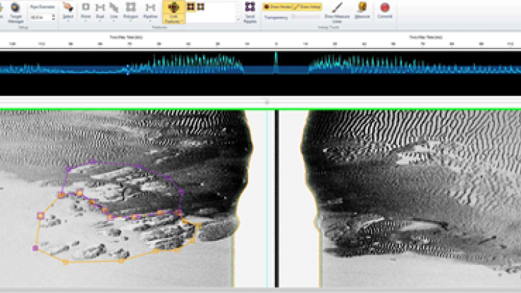
When placing interpretation the user has the option to automatically 'snap' to the nearest nodes. This allows nodes to be placed directly on top of an existing node ensuring there are no gaps or slivers between adjoining node types (image).
Bathymetry Attribute Grid (BAG)
Survey Engine Version 5 allows BAG files to be imported as part of the project. These files contain a grid of elevation values corresponding to a vertical datum. When generating a report the user has the ability to report the Z value as part of the output, which is obtained from querying the relevant BAG file. It can also be used in seismic projects to perform calculations involving depth.
Restore Seabed Shape
A new processing function which will shift the pings to display the original seabed shape based on the altitude of the acquired data. This is most useful for ROV and AUV acquired data which employed terrain following during the data acquisition.
Heave Compensation
Another new processing function which will shift the display of data based on heave values found in the file or added via corrected values.
Copy Fish Heights
Where sidescan sonar has both high and low frequency data in a file, Survey Engine now has the ability to copy the picked seabed values from one frequency to another. This means the user no longer has to pick the seabed twice when using both frequencies, saving on overall processing time. This is completed through the Data Explorer and supports multiple files in one operation.
Support for Non-Geo Referenced Data
Survey Engine Version 5 now supports the ability to import files with (0,0) coordinates and allows coordinate correction to be applied during processing. This feature allows data acquired from AUV platforms - often acquired with no on-line navigation values - to be processed and also prevents rejection of pings in data where on-line navigation has had sporadic drop outs.


