Saildrone USV Gulf Stream Data Mission in Full Swing
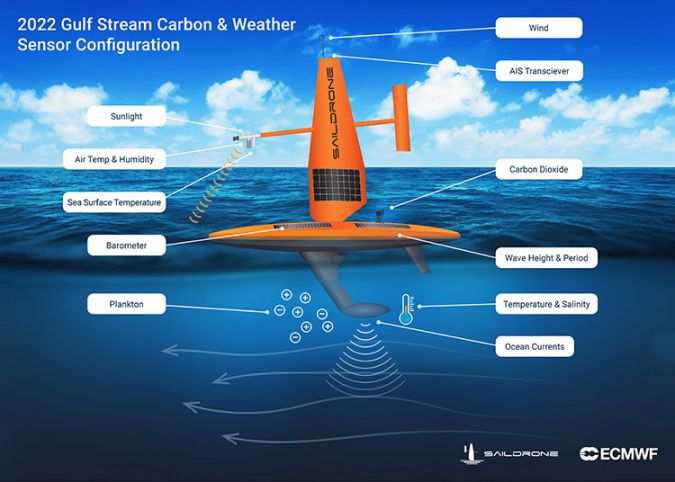
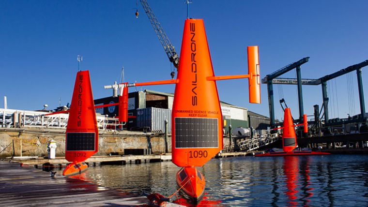
Saildrone recently launched three uncrewed surface vehicles (USVs) on a mission to sail through the North Atlantic’s swiftest current: the Gulf Stream. For six months, these vehicles will collect critical, in situ data that will help scientists improve weather forecasts and carbon accounting.
This audacious mission is being led by scientists from the University of Rhode Island (URI) and the European Centre for Medium-Range Weather Forecasts (ECMWF). Funded by a grant from the Google.org Impact Challenge on Climate, the ocean drones will brave some of the harshest ocean conditions on Earth to collect data in areas that traditional crewed ships cannot tolerate.
Challenging Data Collection Endeavour
The Gulf Stream has a significant impact on both weather systems and the global carbon budget, but collecting data from the area is extremely challenging. The Global Carbon Budget 2021, released at COP26, uses ocean carbon uptake estimates generated by models and sophisticated statistical methods that fill gaps where they have been unable to collect in situ data. However, the various models and their assumptions yield a wide variety of results.
“There is a lot of uncertainty in ocean carbon uptake – nearly four billion tons of CO2 separates the average of the model-based estimates from observation-based estimates. That’s nearly as much CO2 as is emitted by the U.S. [about five billion tons] each year!” said Jaime Palter, a scientist at URI who is co-leading the research. “With more in situ observations, we can do better.”
Designed for Risky Missions
Dramatically increasing our in situ observations of ocean carbon uptake is critical to reducing uncertainty in global carbon estimates, which is necessary for addressing global warming and holding countries accountable for lowering emissions. However, the ocean regions of greatest interest are often those that are the most challenging to sample due to the unforgiving ocean conditions; in particular, places like the Gulf Stream and the Southern Ocean during the winter months. Saildrones, powered by the wind and sun, are designed to collect data in these areas without risking human lives and with a zero operational carbon footprint.
“The Gulf Stream also has a big impact on weather forecasts and climate predictions,” said Philip Browne, a research scientist at ECMWF. “We are excited to be able to target saildrones to collect data from this physically and scientifically challenging region to help improve our Earth system approach to forecasting.”
Saildrone Explorers are well equipped for the risky Gulf Stream mission, having already successfully sailed across the Atlantic in both directions. A group of Saildrone USVs equipped with a special ‘hurricane wing’ recently captured the first-ever live video from inside the eye of the Atlantic category 4 Hurricane Sam and another vehicle completed the first autonomous circumnavigation of Antarctica with a different specially modified wing.
Understanding Critical Climate Challenges
“Since our first science mission in the Arctic in 2015, Saildrone has worked tirelessly to measure climate quality data from Earth’s most remote oceans and deliver that data to scientists all over the world,” said Saildrone founder and CEO Richard Jenkins. “We believe this data will dramatically improve our understanding of critical climate processes and enable more accurate predictions of our future, which will in turn help guide global climate policy and decision making.”
“Data is a critical enabler of our shared goals for sustainability at scale. As the pace of climate action continues to accelerate, a lack of quality data can often leave researchers, advocates and policymakers without a roadmap,” said Brigitte Gosselink, Google.org’s director of product impact. “Google.org believes open climate data is a public good, and we’re thrilled to support this work.”
The mission will operate in the North Atlantic, the vehicles sailing back and forth across the Gulf Stream for six months. Data will be sent via satellite in near real time to help scientists at ECMWF improve their Earth system approach to forecasting, and those at URI working to quantify the Gulf Stream’s role in carbon uptake and predict its stability or vulnerability in the future. The three Saildrone Explorers are expected to be retrieved in Newport, Rhode Island, in mid-2022.