Satellite-based Water Quality Monitoring
EOMAP, Germany, has launched a high-resolution monitoring service for inland and coastal waters, with water quality information directly accessible online through the eoApp web application. Monitoring water quality for inland and coastal waters is a requirement for many government and private sector entities, which includes identifying long-term trends and understanding emerging problems over large areas that contain numerous water bodies – all to be done in near real time.
The service is supported by data from a fleet of satellite sensors and uses proprietary physics-based processing technologies. The base product suite includes water quality parameters such as turbidity, chlorophyll concentrations and organic/inorganic components, all delivered and displayed in digital map form. These information products and services can be generated for any location worldwide. These products and services are standardised, inter-comparable and independent, and do not require any form of ground truth data.
Overview for Authorities
Dr. Jens Arle, Federal Environmental Agency of Germany (UBA), expects that this capability will improve the comprehensive overview of inland water bodies. The temporal sampling rate and the spatial coverage provide relevant information which can substantially support the assessment of surface waters under the Water Framework Directive. The possibility to use detailed time series going back as far as 30 years in time is expected to provide a new and much more detailed view on long term trends of water quality especially for the large number of water bodies which were not or only partly covered by the monitoring programmes in the past.
UBA’s remote sensing-based service sets the new standard for monitoring inland water systems, of almost any size, in their entirety, regardless of geo-political boundaries with sampling frequencies of daily to weekly and at spatial resolutions of 2m, 30m and 500m, according to Karin Schenk, head of EOMAP Water Quality Services.
Awards
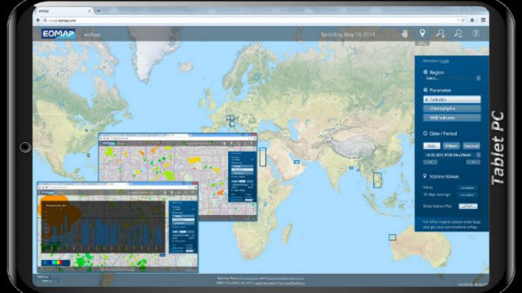
EOMAP has received several awards from the COPERNICUS programme of the European Commission and ESA (European Space Agency) for its work on making affordable aquatic remote sensing products available to industry and the public sector. The EOMAP eoApp Web application provides access to spatial water quality information and enables detailed time series analysis going back for decades in time.
eoApp displays water quality data examples from various countries and continents (Europe, Africa, Asia, Australia, North and South America) and demonstrates the harmonised and global coverage of the service, covering thousands of lakes, dams and rivers.
Since the satellites used are already operating with global coverage, this EOMAP inland water quality monitoring service is ready to be deployed worldwide, whether at local, regional or even continental scales.
Further reading


