Seabed 2030 Enters Crowdsourcing Partnership with Terradepth
Terradepth and The Nippon Foundation-GEBCO Seabed 2030 project are entering a new partnership that will utilize Terradepth’s geospatial data portal known as Absolute Ocean. Seabed 2030 will use Absolute Ocean as a data visualization and exploration tool as part of the international effort to map the entire ocean floor. The announcement was made on the heels of the 2022 United Nations Ocean Conference in Lisbon, Portugal.
Seabed 2030 is a collaborative project between The Nippon Foundation in Japan and the General Bathymetric Chart of the Oceans (GEBCO), with the mission of inspiring 100% mapping of the ocean floor and making it freely available to all by 2030. GEBCO is a joint programme of the International Hydrographic Organization (IHO) and the Intergovernmental Oceanographic Commission of UNESCO (IOC-UNESCO). Seabed 2030 comprises five data centres – four regional centres and one global centre – which are responsible for coordinating and assembling mapping data.
Citizen-sourced Data to Support Bathymetry Mapping
In addition to producing and delivering global GEBCO products, the Seabed 2030 Global Center is also a trusted node for receipt of citizen-sourced data in support of IHO’s Crowdsourced Bathymetry (CSB) initiative which encourages government, academic and privately owned vessels, including superyachts and fishing boats, to participate in increasing our knowledge of the ocean by sharing depth measurements from navigation instruments.
Terradepth’s Absolute Ocean portal will provide Seabed 2030 with a secure platform to allow data contributors to visualize their contributions in an interactive way, and explore how they relate to other open-source data in the platform. “Our Absolute Ocean platform will enable Seabed 2030 to expand their ocean data management and outreach efforts to a global audience of explorers, researchers, educators and ocean enthusiasts, without requiring subject matter expertise to explore or interpret the data,” said Jason Schwartz, Terradepth vice president of corporate development.
Seabed 2030 will process CSB data for onward contribution to IHO’s Data Center for Digital Bathymetry (DCDB). Seabed 2030’s recent partnership with the International SeaKeepers Society will provide some of the first potential users of the platform with custom data loggers being operated by ocean-going vessels to capture georeferenced bathymetric points during their travels.
Cloud-based Ocean Information Platform
“Our partnership with Terradepth will greatly enhance the work we do to support IHO’s CSB initiative, which is a fundamental strand of Seabed 2030’s mission,” commented Dr Helen Snaith, head of Seabed 2030’s Global Center. “The Global Center is excited to use the Absolute Ocean platform as an invaluable tool bringing us one step closer to completing the puzzle of the world’s seabed.”
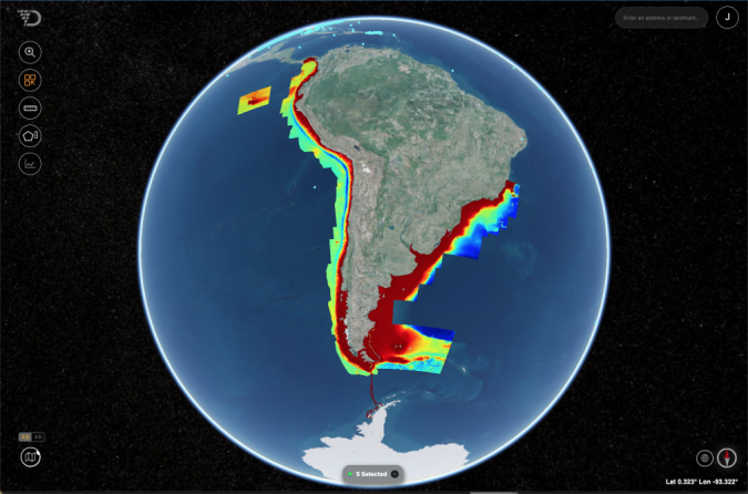
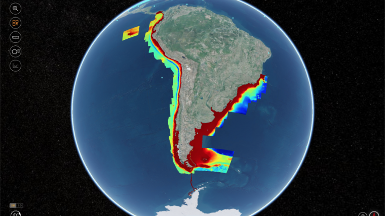
Absolute Ocean is a browser-based portal for the storage, discovery and sharing of Trusted Node data as well as data collected by other third parties. Terradepth developed Absolute Ocean as a cloud-based ocean information management platform where layers of marine data can be studied using the power of machine learning technology. Powerful visualization and analysis functions allow users to examine seafloor data in 2D and 3D from a variety of perspectives, scales and time periods, increasing operational efficiency and the quality control process.
“For applications spanning environmental monitoring, coastal development and offshore energy production, Absolute Ocean gives stakeholders across organizations the tools necessary to make sense of their associated underwater environments,” said Terradepth’s Schwartz.
Sidescan Sonar, Synthetic Aperture Sonar, Multibeam Bathymetry
Terradepth will roll out the commercial version of Absolute Ocean in summer 2022 with multiple subscription levels. Clients will be able to load their own geospatial marine data sets onto the secure platform as well as access the thousands of ocean data files currently included in the platform database – sidescan sonar, synthetic aperture sonar, multibeam bathymetry, satellite-derived bathymetry, Lidar, sub-bottom profiles, magnetometer readings and satellite imagery.
Absolute Ocean also serves as the data delivery platform for the geophysical and hydrographic survey solutions Terradepth offers to a rapidly growing client base in the environmental, telecommunications, construction, energy and maritime industries. To capture seafloor data for these commercial clients, Terradepth operates a fleet of autonomous undersea vehicles (AUVs), which can be configured with multiple sensors for seabed site verification, pre-construction surveys, pipeline/cable inspection, dredging/trenching support, habitat mapping, hazard identification and unexploded munitions detection.