Seabed 2030 Project Enters Partnership with EOMAP
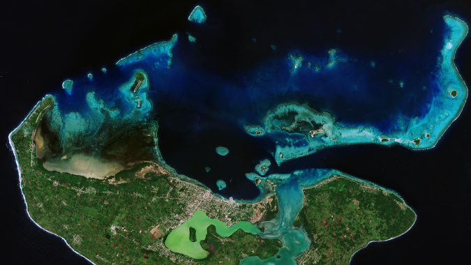
Shallow waters represent the most crucial aquatic zones on Earth and are difficult to survey. Therefore, The Nippon Foundation-GEBCO Seabed 2030 Project has reached a cooperation agreement with EOMAP, a leading provider of shallow water bathymetry from satellite data. The common target is a freely available Ocean Map.
The Nippon Foundation-GEBCO Seabed 2030 Project and EOMAP have signed a Memorandum of Understanding in support of the global initiative to produce the complete map of the ocean floor. The two parties will work together to further the understanding of ocean bathymetry. The effort complements the goals of the United Nations Decade of Ocean Science for Sustainable Development.
Seabed 2030 is a collaborative project between The Nippon Foundation and GEBCO to inspire the complete mapping of the world’s ocean by 2030, and to compile all bathymetric data into the freely available GEBCO Ocean Map. GEBCO is a joint project of the International Hydrographic Organization (IHO) and the Intergovernmental Oceanographic Commission (IOC), and is the only organization with a mandate to map the entire ocean floor.
Mapping the Oceans’ Coastal Zones
EOMAP develops and generates tools and data to map and monitor shallow waters and aquatic ecosystems with satellite data analytics. Its mission is to develop and apply high-quality satellite-derived methods and data to precisely map and monitor the aquatic environment, and thus contribute to an effective management and understanding of this crucial environment.
“Mapping the coastal zones of our oceans can be very complex, and so we’re delighted to welcome the expertise and support of EOMAP,” commented Jamie McMichael-Phillips, project director of Seabed 2030.
“Despite the ocean covering over 70% of the Earth’s surface, around 20% of it has been mapped to date. We have joined the ambitious Seabed 2030 project to contribute with bathymetric data, which is hard or impossible to access otherwise. Our contribution will be – in cooperation with our clients and stakeholders – to fill data gaps in coastal shallow waters and to encourage others to join in,” said Dr Knut Hartmann, COO of EOMAP.
Satellite-derived Bathymetry
Coastal zones are not only critical for biodiversity, coastal protection, navigation and other aspects, they are also subject to constant change. Nevertheless, many are not sufficiently understood. Using satellite data and smart analytics, these aquatic environments can be mapped and monitored in space, in time and on various scales. EOMAP’s mission is to apply and refine these methods and thus support sustainable management practices. Dense shallow-water bathymetry grids from satellites (also known as satellite-derived bathymetry, SDB) from EOMAP are widely used. For example, EOMAP’s SDB has been integrated into nautical charts and the European bathymetry grid of EMODnet Bathymetry, used as baseline information for the management of the Great Barrier Reef and for improving coastal management around the globe. EOMAP, founded in 2006, has its headquarters near Munich, Germany, and maintains offices in Australia, the USA, the United Arab Emirates and Indonesia.