Seafloor Location of MV Nella Dan Mapped During Underwater Earthquakes Research
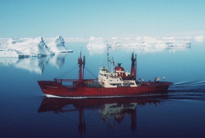
Australian scientists have for the first time mapped in high resolution the seafloor location of MV Nella Dan, a polar resupply ship that was sunk near Macquarie Island nearly 33 years ago. The 75-metre Nella Dan was damaged when it dragged its anchor in bad weather and was driven aground on Macquarie Island in December 1987. All on board were safely transferred to shore but, after careful inspection, the ship was deemed by its Danish owners to be too badly damaged to be salvaged. It was later towed out to sea and sunk in deep water.
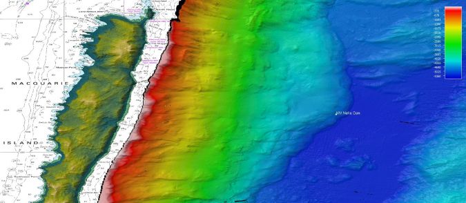
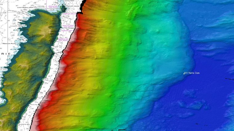
The location where Nella Dan sunk has now been mapped by CSIRO Research Vessel (RV) Investigator during its current voyage. RV Investigator is in the area to study the geology of Macquarie Island to help scientists better understand what triggers massive underwater earthquakes in the region.
The research, which is being led by the Institute for Marine and Antarctic Studies (IMAS) and the Australian National University, aims to improve monitoring for future earthquakes and tsunamis that might affect Australia and New Zealand.
Facilities Program Director of the CSIRO Marine National Facility, Dr Barbara Musso, said the voyage illustrates the wide range of research that each voyage of RV Investigator delivers. “This is just another example of how RV Investigator’s capability delivers wide-ranging research to help improve our knowledge and understanding of our marine environment, including our maritime history,” Dr Musso said.
“The seafloor mapping being done at Macquarie Island is important for the voyage science team to allow them to identify suitable sites to deploy specialized seafloor monitoring equipment called ocean bottom seismometers. At the same time, we have completed mapping of what is a very significant site for the Australian marine research community, the location where Nella Dan sunk in 1987.”
Polar Research Ship
David Lyons, voyage leader on the final voyage of Nella Dan, was shown the mapping and summed up the significance that such maritime heritage research has for many in the community.
“It’s a fitting resting place for such a legendary ship and it’s good to see an old friend again, even if it is just a white dot on a map,” said Mr Lyons.
The Nella Dan was a Danish polar resupply and research ship that played a pioneering role in the development of Australia’s Antarctic research programme for over 25 years. The ship was chartered by the Australian National Antarctic Research Expedition (ANARE) and carried hundreds of researchers on voyages to and from Antarctica between 1961 and 1987.
Mapping of the location where the ship was scuttled shows that the Nella Dan went down in 5,000m of water at the bottom of a steep slope that runs from Macquarie Island down to the deep ocean. The area forms part of Macquarie Ridge, a steep, narrow ocean ridge that includes the island and sits on a highly active tectonic plate boundary between the Australian and Pacific plates.
“The seafloor mapping that RV Investigator does on each and every voyage delivers data that is used by many different groups, both nationally and internationally,” Dr Musso said. “All the data that we collect – whether it be oceanographic, atmospheric, biological, geological or related to maritime heritage – is made freely available for all to use.”
Macquarie Island Marine Park Seabed Mapping
Another organization to benefit from the seafloor mapping work at Macquarie Island is Parks Australia, who manage the Macquarie Island Marine Park.
The marine park covers 162,000 square kilometres with depths ranging from 86 to 6,341 metres. It contains important habitats for a variety of marine life, including seals and seabirds. This is the first time that much of the marine park has been mapped in high resolution.
Seafloor mapping onboard RV Investigator is delivered by CSIRO’s Engineering and Technologies research programme, which provides the onboard expertise to support voyage science teams in their research. This programme is a leader in the development and operation of marine and atmospheric science technology in Australia.
“Not only do our research partners have access to fully-funded sea time on this world-class research vessel, but they also get access to world-class technical expertise and support to get the most from their time on board,” Dr Musso said.
A new ten-year strategy called MNF 2030 has just been released by the CSIRO Marine National Facility to guide broader access to and use of RV Investigator to ensure that it continues to deliver the greatest benefit to researchers, the community and the nation.
Find out more about MNF 2030 and how to access the research, education and training opportunities available on RV Investigator at mnf.csiro.au.